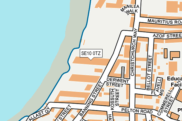
SE10 0TZ is located in the East Greenwich electoral ward, within the London borough of Greenwich and the English Parliamentary constituency of Greenwich and Woolwich. The Sub Integrated Care Board (ICB) Location is NHS South East London ICB - 72Q and the police force is Metropolitan Police. This postcode has been in use since September 2016.


GetTheData
Source: OS OpenMap – Local (Ordnance Survey)
Source: OS VectorMap District (Ordnance Survey)
Licence: Open Government Licence (requires attribution)
| Easting | 539124 |
| Northing | 178473 |
| Latitude | 51.488099 |
| Longitude | 0.002446 |
GetTheData
Source: Open Postcode Geo
Licence: Open Government Licence
| Country | England |
| Postcode District | SE10 |
➜ See where SE10 is on a map ➜ Where is London? | |
GetTheData
Source: Land Registry Price Paid Data
Licence: Open Government Licence
Elevation or altitude of SE10 0TZ as distance above sea level:
| Metres | Feet | |
|---|---|---|
| Elevation | 10m | 33ft |
Elevation is measured from the approximate centre of the postcode, to the nearest point on an OS contour line from OS Terrain 50, which has contour spacing of ten vertical metres.
➜ How high above sea level am I? Find the elevation of your current position using your device's GPS.
GetTheData
Source: Open Postcode Elevation
Licence: Open Government Licence
| Ward | East Greenwich |
| Constituency | Greenwich And Woolwich |
GetTheData
Source: ONS Postcode Database
Licence: Open Government Licence
| King William Lane | Greenwich | 370m |
| Christ Church Primary School (Blackwall Lane) | Greenwich | 370m |
| Pelton Road (Blackwall Lane) | Greenwich | 380m |
| Tyler Street (Trafalgar Road) | Greenwich | 383m |
| Tyler Street (Trafalgar Road) | Greenwich | 389m |
| Island Gardens Dlr Station (Manchester Road) | Island Gardens | 873m |
| Cutty Sark (For Maritime Greenwich) Dlr Station (Creek Road) | Greenwich | 1,164m |
| Mudchute Dlr Station (East Ferry Road) | Mudchute | 1,226m |
| Emirates Greenwich Peninsula (East Parkside) | North Greenwich | 1,341m |
| North Greenwich Underground Station | North Greenwich | 1,382m |
| Maze Hill Station | 0.6km |
| Westcombe Park Station | 1.2km |
| Greenwich Station | 1.6km |
GetTheData
Source: NaPTAN
Licence: Open Government Licence
| Percentage of properties with Next Generation Access | 100.0% |
| Percentage of properties with Superfast Broadband | 100.0% |
| Percentage of properties with Ultrafast Broadband | 100.0% |
| Percentage of properties with Full Fibre Broadband | 100.0% |
Superfast Broadband is between 30Mbps and 300Mbps
Ultrafast Broadband is > 300Mbps
Ofcom does not currently provide download speed data for SE10 0TZ. This is because there are less than four broadband connections in this postcode.
Ofcom does not currently provide upload speed data for SE10 0TZ. This is because there are less than four broadband connections in this postcode.
| Percentage of properties unable to receive 2Mbps | 0.0% |
| Percentage of properties unable to receive 5Mbps | 0.0% |
| Percentage of properties unable to receive 10Mbps | 0.0% |
| Percentage of properties unable to receive 30Mbps | 0.0% |
GetTheData
Source: Ofcom
Licence: Ofcom Terms of Use (requires attribution)
GetTheData
Source: ONS Postcode Database
Licence: Open Government Licence


➜ Get more ratings from the Food Standards Agency
GetTheData
Source: Food Standards Agency
Licence: FSA terms & conditions
| Last Collection | |||
|---|---|---|---|
| Location | Mon-Fri | Sat | Distance |
| Post Office | 18:30 | 12:00 | 369m |
| Blackwall Tunnel / Azof Street | 17:30 | 12:00 | 402m |
| Eastney Street | 17:30 | 12:00 | 600m |
GetTheData
Source: Dracos
Licence: Creative Commons Attribution-ShareAlike
| Risk of SE10 0TZ flooding from rivers and sea | Very Low |
| ➜ SE10 0TZ flood map | |
GetTheData
Source: Open Flood Risk by Postcode
Licence: Open Government Licence
The below table lists the International Territorial Level (ITL) codes (formerly Nomenclature of Territorial Units for Statistics (NUTS) codes) and Local Administrative Units (LAU) codes for SE10 0TZ:
| ITL 1 Code | Name |
|---|---|
| TLI | London |
| ITL 2 Code | Name |
| TLI5 | Outer London - East and North East |
| ITL 3 Code | Name |
| TLI51 | Bexley and Greenwich |
| LAU 1 Code | Name |
| E09000011 | Greenwich |
GetTheData
Source: ONS Postcode Directory
Licence: Open Government Licence
The below table lists the Census Output Area (OA), Lower Layer Super Output Area (LSOA), and Middle Layer Super Output Area (MSOA) for SE10 0TZ:
| Code | Name | |
|---|---|---|
| OA | E00176506 | |
| LSOA | E01001668 | Greenwich 036C |
| MSOA | E02006929 | Greenwich 036 |
GetTheData
Source: ONS Postcode Directory
Licence: Open Government Licence
| SE10 0GA | River Gardens Walk | 63m |
| SE10 0GB | River Gardens Walk | 63m |
| SE10 0FD | Banning Street | 90m |
| SE10 0NY | Banning Street | 99m |
| SE10 0AD | Derwent Street | 104m |
| SE10 0AA | Kossuth Street | 124m |
| SE10 0FE | Banning Street | 140m |
| SE10 0AE | Christchurch Way | 151m |
| SE10 0FF | Banning Street | 166m |
| SE10 0AB | Christchurch Way | 168m |
GetTheData
Source: Open Postcode Geo; Land Registry Price Paid Data
Licence: Open Government Licence