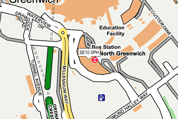
SE10 0PH is located in the Greenwich Peninsula electoral ward, within the London borough of Greenwich and the English Parliamentary constituency of Greenwich and Woolwich. The Sub Integrated Care Board (ICB) Location is NHS South East London ICB - 72Q and the police force is Metropolitan Police. This postcode has been in use since December 1999.


GetTheData
Source: OS OpenMap – Local (Ordnance Survey)
Source: OS VectorMap District (Ordnance Survey)
Licence: Open Government Licence (requires attribution)
| Easting | 539142 |
| Northing | 179831 |
| Latitude | 51.500298 |
| Longitude | 0.003240 |
GetTheData
Source: Open Postcode Geo
Licence: Open Government Licence
| Country | England |
| Postcode District | SE10 |
➜ See where SE10 is on a map ➜ Where is London? | |
GetTheData
Source: Land Registry Price Paid Data
Licence: Open Government Licence
Elevation or altitude of SE10 0PH as distance above sea level:
| Metres | Feet | |
|---|---|---|
| Elevation | 0m | 0ft |
Elevation is measured from the approximate centre of the postcode, to the nearest point on an OS contour line from OS Terrain 50, which has contour spacing of ten vertical metres.
➜ How high above sea level am I? Find the elevation of your current position using your device's GPS.
GetTheData
Source: Open Postcode Elevation
Licence: Open Government Licence
| Ward | Greenwich Peninsula |
| Constituency | Greenwich And Woolwich |
GetTheData
Source: ONS Postcode Database
Licence: Open Government Licence
| North Greenwich Station | North Greenwich | 21m |
| North Greenwich Station | North Greenwich | 42m |
| North Greenwich Station | North Greenwich | 75m |
| North Greenwich Station | North Greenwich | 78m |
| North Greenwich Station (North Greenwich Bus Station) | North Greenwich | 92m |
| North Greenwich Underground Station | North Greenwich | 77m |
| Emirates Greenwich Peninsula (East Parkside) | North Greenwich | 365m |
| East India Dlr Station (Aspen Way) | East India | 1,079m |
| Blackwall Dlr Station (Preston's Road) | Blackwall | 1,110m |
| Emirates Royal Docks (Western Gateway) | Royal Victoria | 1,302m |
| Maze Hill Station | 2km |
| Westcombe Park Station | 2.1km |
| Charlton Station | 2.5km |
GetTheData
Source: NaPTAN
Licence: Open Government Licence
GetTheData
Source: ONS Postcode Database
Licence: Open Government Licence


➜ Get more ratings from the Food Standards Agency
GetTheData
Source: Food Standards Agency
Licence: FSA terms & conditions
| Last Collection | |||
|---|---|---|---|
| Location | Mon-Fri | Sat | Distance |
| Prestons Road | 17:30 | 11:30 | 848m |
| Wood Wharf Business Park | 19:00 | 853m | |
| John Harrison Way | 17:30 | 12:00 | 881m |
GetTheData
Source: Dracos
Licence: Creative Commons Attribution-ShareAlike
| Risk of SE10 0PH flooding from rivers and sea | Very Low |
| ➜ SE10 0PH flood map | |
GetTheData
Source: Open Flood Risk by Postcode
Licence: Open Government Licence
The below table lists the International Territorial Level (ITL) codes (formerly Nomenclature of Territorial Units for Statistics (NUTS) codes) and Local Administrative Units (LAU) codes for SE10 0PH:
| ITL 1 Code | Name |
|---|---|
| TLI | London |
| ITL 2 Code | Name |
| TLI5 | Outer London - East and North East |
| ITL 3 Code | Name |
| TLI51 | Bexley and Greenwich |
| LAU 1 Code | Name |
| E09000011 | Greenwich |
GetTheData
Source: ONS Postcode Directory
Licence: Open Government Licence
The below table lists the Census Output Area (OA), Lower Layer Super Output Area (LSOA), and Middle Layer Super Output Area (MSOA) for SE10 0PH:
| Code | Name | |
|---|---|---|
| OA | E00008308 | |
| LSOA | E01001667 | Greenwich 036B |
| MSOA | E02006929 | Greenwich 036 |
GetTheData
Source: ONS Postcode Directory
Licence: Open Government Licence
| SE10 0QE | Tunnel Avenue | 554m |
| SE10 0NW | Pilot Walk | 649m |
| SE10 0NN | Chandlers Avenue | 694m |
| SE10 0NQ | Reminder Lane | 697m |
| SE10 0PP | East Parkside | 725m |
| SE10 0SN | Chandlers Avenue | 731m |
| SE10 0JF | East Parkside | 744m |
| E14 3YH | Folly Wall | 767m |
| E14 3FB | Manchester Road | 774m |
| SE10 0GH | Barge Walk | 776m |
GetTheData
Source: Open Postcode Geo; Land Registry Price Paid Data
Licence: Open Government Licence