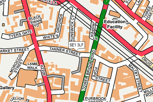
SE1 3LF lies on Tanner Street in London. SE1 3LF is located in the London Bridge & West Bermondsey electoral ward, within the London borough of Southwark and the English Parliamentary constituency of Bermondsey and Old Southwark. The Sub Integrated Care Board (ICB) Location is NHS South East London ICB - 72Q and the police force is Metropolitan Police. This postcode has been in use since December 1998.


GetTheData
Source: OS OpenMap – Local (Ordnance Survey)
Source: OS VectorMap District (Ordnance Survey)
Licence: Open Government Licence (requires attribution)
| Easting | 533401 |
| Northing | 179680 |
| Latitude | 51.500323 |
| Longitude | -0.079503 |
GetTheData
Source: Open Postcode Geo
Licence: Open Government Licence
| Street | Tanner Street |
| Town/City | London |
| Country | England |
| Postcode District | SE1 |
➜ See where SE1 is on a map ➜ Where is Bermondsey? | |
GetTheData
Source: Land Registry Price Paid Data
Licence: Open Government Licence
Elevation or altitude of SE1 3LF as distance above sea level:
| Metres | Feet | |
|---|---|---|
| Elevation | 10m | 33ft |
Elevation is measured from the approximate centre of the postcode, to the nearest point on an OS contour line from OS Terrain 50, which has contour spacing of ten vertical metres.
➜ How high above sea level am I? Find the elevation of your current position using your device's GPS.
GetTheData
Source: Open Postcode Elevation
Licence: Open Government Licence
| Ward | London Bridge & West Bermondsey |
| Constituency | Bermondsey And Old Southwark |
GetTheData
Source: ONS Postcode Database
Licence: Open Government Licence
| Druid Street | Bermondsey | 117m |
| Abbey Street (Tower Bridge Road) | Bermondsey | 145m |
| Tower Bridge Road (Druid Street) | London Bridge | 169m |
| Druid Street (Tower Bridge Road) | Bermondsey | 228m |
| Abbey Street (Tower Bridge Road) | Bermondsey | 239m |
| London Bridge Underground Station | London Bridge | 885m |
| Borough Underground Station | The Borough | 968m |
| Tower Hill Underground Station | Tower Hill | 1,092m |
| Bermondsey Underground Station | Bermondsey | 1,124m |
| Tower Gateway Dlr Station (Minories) | Tower Gateway | 1,190m |
| London Bridge Station | 0.7km |
| London Fenchurch Street Station | 1.3km |
| London Cannon Street Station | 1.4km |
GetTheData
Source: NaPTAN
Licence: Open Government Licence
| Median download speed | 13.8Mbps |
| Average download speed | 13.2Mbps |
| Maximum download speed | 16.74Mbps |
| Median upload speed | 1.1Mbps |
| Average upload speed | 1.1Mbps |
| Maximum upload speed | 1.24Mbps |
GetTheData
Source: Ofcom
Licence: Ofcom Terms of Use (requires attribution)
Estimated total energy consumption in SE1 3LF by fuel type, 2015.
| Consumption (kWh) | 124,449 |
|---|---|
| Meter count | 19 |
| Mean (kWh/meter) | 6,550 |
| Median (kWh/meter) | 6,165 |
| Consumption (kWh) | 56,355 |
|---|---|
| Meter count | 19 |
| Mean (kWh/meter) | 2,966 |
| Median (kWh/meter) | 2,629 |
GetTheData
Source: Postcode level gas estimates: 2015 (experimental)
Source: Postcode level electricity estimates: 2015 (experimental)
Licence: Open Government Licence
GetTheData
Source: ONS Postcode Database
Licence: Open Government Licence


➜ Get more ratings from the Food Standards Agency
GetTheData
Source: Food Standards Agency
Licence: FSA terms & conditions
| Last Collection | |||
|---|---|---|---|
| Location | Mon-Fri | Sat | Distance |
| Post Office | 18:45 | 13:00 | 165m |
| Tanner Street | 18:30 | 13:00 | 176m |
| Tooley Street | 18:30 | 13:00 | 286m |
GetTheData
Source: Dracos
Licence: Creative Commons Attribution-ShareAlike
| Risk of SE1 3LF flooding from rivers and sea | Very Low |
| ➜ SE1 3LF flood map | |
GetTheData
Source: Open Flood Risk by Postcode
Licence: Open Government Licence
The below table lists the International Territorial Level (ITL) codes (formerly Nomenclature of Territorial Units for Statistics (NUTS) codes) and Local Administrative Units (LAU) codes for SE1 3LF:
| ITL 1 Code | Name |
|---|---|
| TLI | London |
| ITL 2 Code | Name |
| TLI4 | Inner London - East |
| ITL 3 Code | Name |
| TLI44 | Lewisham and Southwark |
| LAU 1 Code | Name |
| E09000028 | Southwark |
GetTheData
Source: ONS Postcode Directory
Licence: Open Government Licence
The below table lists the Census Output Area (OA), Lower Layer Super Output Area (LSOA), and Middle Layer Super Output Area (MSOA) for SE1 3LF:
| Code | Name | |
|---|---|---|
| OA | E00167490 | |
| LSOA | E01032646 | Southwark 003I |
| MSOA | E02000809 | Southwark 003 |
GetTheData
Source: ONS Postcode Directory
Licence: Open Government Licence
| SE1 3LH | Brunswick Court | 13m |
| SE1 3LL | Tanner Street | 32m |
| SE1 3LG | Tanner Street | 38m |
| SE1 3LN | Tower Bridge Road | 38m |
| SE1 3JT | Archie Street | 57m |
| SE1 3LJ | Maltings Place | 66m |
| SE1 3LD | Tanner Street | 72m |
| SE1 3UY | Bell Yard Mews | 85m |
| SE1 3PH | Tanner Street | 85m |
| SE1 3LY | Fellmongers Path | 98m |
GetTheData
Source: Open Postcode Geo; Land Registry Price Paid Data
Licence: Open Government Licence