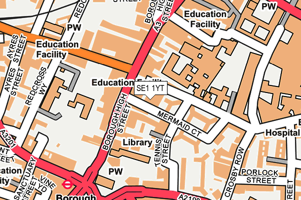
SE1 1YT is located in the Chaucer electoral ward, within the London borough of Southwark and the English Parliamentary constituency of Bermondsey and Old Southwark. The Sub Integrated Care Board (ICB) Location is NHS South East London ICB - 72Q and the police force is Metropolitan Police. This postcode has been in use since January 1980.


GetTheData
Source: OS OpenMap – Local (Ordnance Survey)
Source: OS VectorMap District (Ordnance Survey)
Licence: Open Government Licence (requires attribution)
| Easting | 532578 |
| Northing | 179927 |
| Latitude | 51.502737 |
| Longitude | -0.091260 |
GetTheData
Source: Open Postcode Geo
Licence: Open Government Licence
| Country | England |
| Postcode District | SE1 |
➜ See where SE1 is on a map ➜ Where is Southwark? | |
GetTheData
Source: Land Registry Price Paid Data
Licence: Open Government Licence
Elevation or altitude of SE1 1YT as distance above sea level:
| Metres | Feet | |
|---|---|---|
| Elevation | 10m | 33ft |
Elevation is measured from the approximate centre of the postcode, to the nearest point on an OS contour line from OS Terrain 50, which has contour spacing of ten vertical metres.
➜ How high above sea level am I? Find the elevation of your current position using your device's GPS.
GetTheData
Source: Open Postcode Elevation
Licence: Open Government Licence
| Ward | Chaucer |
| Constituency | Bermondsey And Old Southwark |
GetTheData
Source: ONS Postcode Database
Licence: Open Government Licence
| Union Street Borough High St (Borough High Street) | The Borough | 40m |
| Union Street Borough High St (Borough High Street) | The Borough | 65m |
| Southwark Street The Borough | The Borough | 146m |
| Tennis Street | The Borough | 190m |
| Tennis Street | The Borough | 207m |
| Borough Underground Station | The Borough | 225m |
| London Bridge Underground Station | London Bridge | 371m |
| Monument Underground Station | Monument | 959m |
| Southwark Underground Station | Southwark | 960m |
| Cannon Street Underground Station | Cannon Street | 978m |
| London Bridge Station | 0.4km |
| London Cannon Street Station | 1km |
| Elephant & Castle Station | 1.1km |
GetTheData
Source: NaPTAN
Licence: Open Government Licence
GetTheData
Source: ONS Postcode Database
Licence: Open Government Licence


➜ Get more ratings from the Food Standards Agency
GetTheData
Source: Food Standards Agency
Licence: FSA terms & conditions
| Last Collection | |||
|---|---|---|---|
| Location | Mon-Fri | Sat | Distance |
| 140 Borough High Street | 18:30 | 13:00 | 88m |
| 91 Borough High Street | 18:30 | 13:00 | 168m |
| Southwark Street | 18:30 | 13:00 | 224m |
GetTheData
Source: Dracos
Licence: Creative Commons Attribution-ShareAlike
| Risk of SE1 1YT flooding from rivers and sea | Very Low |
| ➜ SE1 1YT flood map | |
GetTheData
Source: Open Flood Risk by Postcode
Licence: Open Government Licence
The below table lists the International Territorial Level (ITL) codes (formerly Nomenclature of Territorial Units for Statistics (NUTS) codes) and Local Administrative Units (LAU) codes for SE1 1YT:
| ITL 1 Code | Name |
|---|---|
| TLI | London |
| ITL 2 Code | Name |
| TLI4 | Inner London - East |
| ITL 3 Code | Name |
| TLI44 | Lewisham and Southwark |
| LAU 1 Code | Name |
| E09000028 | Southwark |
GetTheData
Source: ONS Postcode Directory
Licence: Open Government Licence
The below table lists the Census Output Area (OA), Lower Layer Super Output Area (LSOA), and Middle Layer Super Output Area (MSOA) for SE1 1YT:
| Code | Name | |
|---|---|---|
| OA | E00019839 | |
| LSOA | E01003939 | Southwark 002E |
| MSOA | E02000808 | Southwark 002 |
GetTheData
Source: ONS Postcode Directory
Licence: Open Government Licence
| SE1 1YU | Newcomen Street | 37m |
| SE1 1HR | Borough High Street | 40m |
| SE1 1YY | Tennis Street | 92m |
| SE1 1YF | Tennis Street | 92m |
| SE1 1LB | Borough High Street | 95m |
| SE1 1LL | Borough High Street | 96m |
| SE1 1NP | Borough High Street | 97m |
| SE1 1YX | Tabard Garden Estate | 97m |
| SE1 1SZ | Union Street | 110m |
| SE1 1GE | Maidstone Buildings Mews | 137m |
GetTheData
Source: Open Postcode Geo; Land Registry Price Paid Data
Licence: Open Government Licence