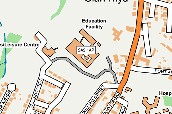
SA9 1AP is located in the Ynyscedwyn electoral ward, within the unitary authority of Powys and the Welsh Parliamentary constituency of Brecon and Radnorshire. The Local Health Board is Powys Teaching and the police force is Dyfed-Powys. This postcode has been in use since January 1980.


GetTheData
Source: OS OpenMap – Local (Ordnance Survey)
Source: OS VectorMap District (Ordnance Survey)
Licence: Open Government Licence (requires attribution)
| Easting | 278131 |
| Northing | 209291 |
| Latitude | 51.768989 |
| Longitude | -3.767547 |
GetTheData
Source: Open Postcode Geo
Licence: Open Government Licence
| Country | Wales |
| Postcode District | SA9 |
➜ See where SA9 is on a map ➜ Where is Glan-rhyd? | |
GetTheData
Source: Land Registry Price Paid Data
Licence: Open Government Licence
Elevation or altitude of SA9 1AP as distance above sea level:
| Metres | Feet | |
|---|---|---|
| Elevation | 70m | 230ft |
Elevation is measured from the approximate centre of the postcode, to the nearest point on an OS contour line from OS Terrain 50, which has contour spacing of ten vertical metres.
➜ How high above sea level am I? Find the elevation of your current position using your device's GPS.
GetTheData
Source: Open Postcode Elevation
Licence: Open Government Licence
| Ward | Ynyscedwyn |
| Constituency | Brecon And Radnorshire |
GetTheData
Source: ONS Postcode Database
Licence: Open Government Licence
| Hospital (Yniscedwyn Road) | Glanrhyd | 155m |
| Hospital (Glanrhyd Road) | Glanrhyd | 185m |
| Claphon Crossing (Yniscedwyn Road) | Glanrhyd | 231m |
| Post Office (Wind Road) | Glanrhyd | 311m |
| Post Office (Wind Road) | Glanrhyd | 319m |
GetTheData
Source: NaPTAN
Licence: Open Government Licence
GetTheData
Source: ONS Postcode Database
Licence: Open Government Licence


➜ Get more ratings from the Food Standards Agency
GetTheData
Source: Food Standards Agency
Licence: FSA terms & conditions
| Last Collection | |||
|---|---|---|---|
| Location | Mon-Fri | Sat | Distance |
| Gurnos P O | 17:30 | 12:00 | 950m |
| Ystradgynlais P O | 17:30 | 12:00 | 1,136m |
| Ynysydarren P O | 17:30 | 12:00 | 1,453m |
GetTheData
Source: Dracos
Licence: Creative Commons Attribution-ShareAlike
The below table lists the International Territorial Level (ITL) codes (formerly Nomenclature of Territorial Units for Statistics (NUTS) codes) and Local Administrative Units (LAU) codes for SA9 1AP:
| ITL 1 Code | Name |
|---|---|
| TLL | Wales |
| ITL 2 Code | Name |
| TLL2 | East Wales |
| ITL 3 Code | Name |
| TLL24 | Powys |
| LAU 1 Code | Name |
| W06000023 | Powys |
GetTheData
Source: ONS Postcode Directory
Licence: Open Government Licence
The below table lists the Census Output Area (OA), Lower Layer Super Output Area (LSOA), and Middle Layer Super Output Area (MSOA) for SA9 1AP:
| Code | Name | |
|---|---|---|
| OA | W00002688 | |
| LSOA | W01000502 | Powys 021C |
| MSOA | W02000416 | Powys 021 |
GetTheData
Source: ONS Postcode Directory
Licence: Open Government Licence
| SA9 1EL | Maes Y Dderwen Gardens | 125m |
| SA9 1AT | William Street | 174m |
| SA9 1BE | Rowton Villas | 180m |
| SA9 1BG | Glannant | 210m |
| SA9 1AU | Glanrhyd Road | 246m |
| SA9 1AN | Tudor Street | 268m |
| SA9 1BP | Ynyscedwyn Road | 273m |
| SA9 1AL | Croesffyrdd | 275m |
| SA9 1AJ | Dumfries Place | 280m |
| SA9 1AW | Gough Avenue | 287m |
GetTheData
Source: Open Postcode Geo; Land Registry Price Paid Data
Licence: Open Government Licence