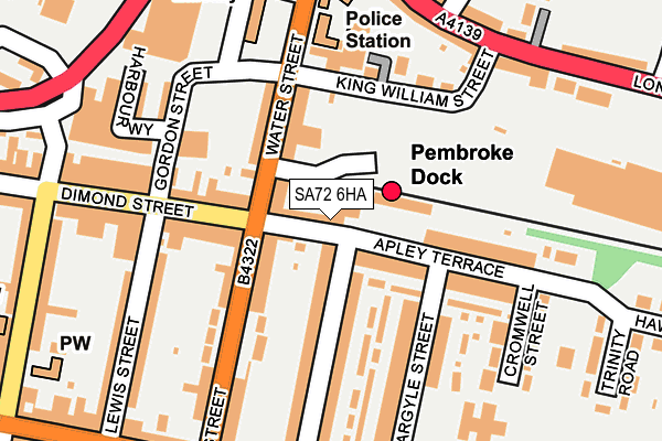
SA72 6HA lies on Dimond Street East in Pembroke Dock. SA72 6HA is located in the Pembroke Dock: Bush electoral ward, within the unitary authority of Pembrokeshire and the Welsh Parliamentary constituency of Carmarthen West and South Pembrokeshire. The Local Health Board is Hywel Dda University and the police force is Dyfed-Powys. This postcode has been in use since January 1980.


GetTheData
Source: OS OpenMap – Local (Ordnance Survey)
Source: OS VectorMap District (Ordnance Survey)
Licence: Open Government Licence (requires attribution)
| Easting | 196995 |
| Northing | 203537 |
| Latitude | 51.693790 |
| Longitude | -4.938724 |
GetTheData
Source: Open Postcode Geo
Licence: Open Government Licence
| Street | Dimond Street East |
| Town/City | Pembroke Dock |
| Country | Wales |
| Postcode District | SA72 |
➜ See where SA72 is on a map ➜ Where is Pembroke Dock? | |
GetTheData
Source: Land Registry Price Paid Data
Licence: Open Government Licence
Elevation or altitude of SA72 6HA as distance above sea level:
| Metres | Feet | |
|---|---|---|
| Elevation | 10m | 33ft |
Elevation is measured from the approximate centre of the postcode, to the nearest point on an OS contour line from OS Terrain 50, which has contour spacing of ten vertical metres.
➜ How high above sea level am I? Find the elevation of your current position using your device's GPS.
GetTheData
Source: Open Postcode Elevation
Licence: Open Government Licence
| Ward | Pembroke Dock: Bush |
| Constituency | Carmarthen West And South Pembrokeshire |
GetTheData
Source: ONS Postcode Database
Licence: Open Government Licence
55, DIMOND STREET, PEMBROKE DOCK, SA72 6HA 2006 24 MAR £100,000 |
41, DIMOND STREET EAST, PEMBROKE DOCK, SA72 6HA 1997 21 MAR £28,500 |
GetTheData
Source: HM Land Registry Price Paid Data
Licence: Contains HM Land Registry data © Crown copyright and database right 2025. This data is licensed under the Open Government Licence v3.0.
| Pembroke Dock Rail Station (Water Street) | Pembroke Dock | 35m |
| Pembroke Dock Railway Hub (Appleby Terrace) | Pembroke Dock | 37m |
| Pembroke Dock Railway Station (Railway Station Yard) | Pembroke Dock | 38m |
| Railway Station (Apley Terrace) | Pembroke Dock | 41m |
| Police Station (Water Street) | Pembroke Dock | 124m |
| Pembroke Dock Station | 0km |
| Pembroke Station | 3.2km |
| Lamphey Station | 5.4km |
GetTheData
Source: NaPTAN
Licence: Open Government Licence
| Percentage of properties with Next Generation Access | 100.0% |
| Percentage of properties with Superfast Broadband | 100.0% |
| Percentage of properties with Ultrafast Broadband | 0.0% |
| Percentage of properties with Full Fibre Broadband | 0.0% |
Superfast Broadband is between 30Mbps and 300Mbps
Ultrafast Broadband is > 300Mbps
| Median download speed | 65.8Mbps |
| Average download speed | 59.0Mbps |
| Maximum download speed | 80.00Mbps |
| Median upload speed | 19.5Mbps |
| Average upload speed | 15.1Mbps |
| Maximum upload speed | 20.00Mbps |
| Percentage of properties unable to receive 2Mbps | 0.0% |
| Percentage of properties unable to receive 5Mbps | 0.0% |
| Percentage of properties unable to receive 10Mbps | 0.0% |
| Percentage of properties unable to receive 30Mbps | 0.0% |
GetTheData
Source: Ofcom
Licence: Ofcom Terms of Use (requires attribution)
Estimated total energy consumption in SA72 6HA by fuel type, 2015.
| Consumption (kWh) | 121,331 |
|---|---|
| Meter count | 12 |
| Mean (kWh/meter) | 10,111 |
| Median (kWh/meter) | 8,530 |
| Consumption (kWh) | 17,644 |
|---|---|
| Meter count | 9 |
| Mean (kWh/meter) | 1,960 |
| Median (kWh/meter) | 2,047 |
GetTheData
Source: Postcode level gas estimates: 2015 (experimental)
Source: Postcode level electricity estimates: 2015 (experimental)
Licence: Open Government Licence
GetTheData
Source: ONS Postcode Database
Licence: Open Government Licence


➜ Get more ratings from the Food Standards Agency
GetTheData
Source: Food Standards Agency
Licence: FSA terms & conditions
| Last Collection | |||
|---|---|---|---|
| Location | Mon-Fri | Sat | Distance |
| High St | 16:15 | 12:00 | 1,732m |
| Riverside Av | 16:15 | 12:00 | 1,781m |
| Burton P O | 12:00 | 12:00 | 1,919m |
GetTheData
Source: Dracos
Licence: Creative Commons Attribution-ShareAlike
The below table lists the International Territorial Level (ITL) codes (formerly Nomenclature of Territorial Units for Statistics (NUTS) codes) and Local Administrative Units (LAU) codes for SA72 6HA:
| ITL 1 Code | Name |
|---|---|
| TLL | Wales |
| ITL 2 Code | Name |
| TLL1 | West Wales and The Valleys |
| ITL 3 Code | Name |
| TLL14 | South West Wales |
| LAU 1 Code | Name |
| W06000009 | Pembrokeshire |
GetTheData
Source: ONS Postcode Directory
Licence: Open Government Licence
The below table lists the Census Output Area (OA), Lower Layer Super Output Area (LSOA), and Middle Layer Super Output Area (MSOA) for SA72 6HA:
| Code | Name | |
|---|---|---|
| OA | W00003230 | |
| LSOA | W01000602 | Pembrokeshire 013C |
| MSOA | W02000138 | Pembrokeshire 013 |
GetTheData
Source: ONS Postcode Directory
Licence: Open Government Licence
| SA72 6HJ | Apley Terrace | 80m |
| SA72 6DN | Water Street | 105m |
| SA72 6BT | Dimond Street | 130m |
| SA72 6HB | Gwyther Street | 131m |
| SA72 6HN | Hawkstone Road | 137m |
| SA72 6DR | King William Street | 140m |
| SA72 6HH | Gwyther Street | 143m |
| SA72 6DL | Laws Street | 152m |
| SA72 6DP | King William Court | 153m |
| SA72 6DW | Water Street | 154m |
GetTheData
Source: Open Postcode Geo; Land Registry Price Paid Data
Licence: Open Government Licence