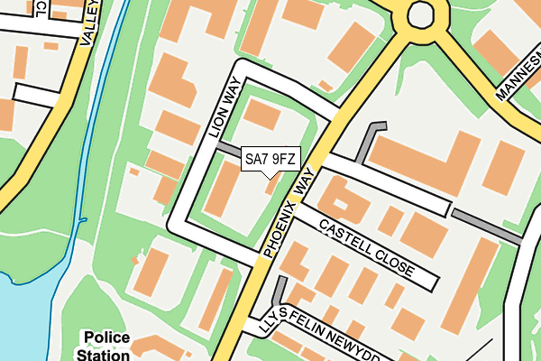
SA7 9FZ lies on Phoenix Business Park in Swansea Enterprise Park, Swansea. SA7 9FZ is located in the Llansamlet electoral ward, within the unitary authority of Swansea and the Welsh Parliamentary constituency of Swansea East. The Local Health Board is Swansea Bay University and the police force is South Wales. This postcode has been in use since December 2000.


GetTheData
Source: OS OpenMap – Local (Ordnance Survey)
Source: OS VectorMap District (Ordnance Survey)
Licence: Open Government Licence (requires attribution)
| Easting | 267976 |
| Northing | 197153 |
| Latitude | 51.657616 |
| Longitude | -3.910045 |
GetTheData
Source: Open Postcode Geo
Licence: Open Government Licence
| Street | Phoenix Business Park |
| Locality | Swansea Enterprise Park |
| Town/City | Swansea |
| Country | Wales |
| Postcode District | SA7 |
➜ See where SA7 is on a map ➜ Where is Swansea? | |
GetTheData
Source: Land Registry Price Paid Data
Licence: Open Government Licence
Elevation or altitude of SA7 9FZ as distance above sea level:
| Metres | Feet | |
|---|---|---|
| Elevation | 10m | 33ft |
Elevation is measured from the approximate centre of the postcode, to the nearest point on an OS contour line from OS Terrain 50, which has contour spacing of ten vertical metres.
➜ How high above sea level am I? Find the elevation of your current position using your device's GPS.
GetTheData
Source: Open Postcode Elevation
Licence: Open Government Licence
| Ward | Llansamlet |
| Constituency | Swansea East |
GetTheData
Source: ONS Postcode Database
Licence: Open Government Licence
| Lion Way (Phoenix Way) | Enterprise Park | 90m |
| Lion Way (Phoenix Way) | Enterprise Park | 190m |
| Castle Court (Phoenix Way) | Llansamlet | 297m |
| Johnsons Cleaners (Valley Way) | Enterprise Park | 460m |
| Johnsons Cleaners (Valley Way) | Enterprise Park | 463m |
| Llansamlet Station | 1.8km |
| Swansea Station | 4.2km |
| Skewen Station | 4.4km |
GetTheData
Source: NaPTAN
Licence: Open Government Licence
GetTheData
Source: ONS Postcode Database
Licence: Open Government Licence


➜ Get more ratings from the Food Standards Agency
GetTheData
Source: Food Standards Agency
Licence: FSA terms & conditions
| Last Collection | |||
|---|---|---|---|
| Location | Mon-Fri | Sat | Distance |
| Fendrod Way | 18:45 | 10:45 | 146m |
| Kemys Way | 18:45 | 00:01 | 228m |
| Tescos Stores Ltd | 18:30 | 12:45 | 584m |
GetTheData
Source: Dracos
Licence: Creative Commons Attribution-ShareAlike
The below table lists the International Territorial Level (ITL) codes (formerly Nomenclature of Territorial Units for Statistics (NUTS) codes) and Local Administrative Units (LAU) codes for SA7 9FZ:
| ITL 1 Code | Name |
|---|---|
| TLL | Wales |
| ITL 2 Code | Name |
| TLL1 | West Wales and The Valleys |
| ITL 3 Code | Name |
| TLL18 | Swansea |
| LAU 1 Code | Name |
| W06000011 | Swansea |
GetTheData
Source: ONS Postcode Directory
Licence: Open Government Licence
The below table lists the Census Output Area (OA), Lower Layer Super Output Area (LSOA), and Middle Layer Super Output Area (MSOA) for SA7 9FZ:
| Code | Name | |
|---|---|---|
| OA | W00004291 | |
| LSOA | W01000794 | Swansea 010A |
| MSOA | W02000177 | Swansea 010 |
GetTheData
Source: ONS Postcode Directory
Licence: Open Government Licence
| SA7 9FU | Phoenix Way | 141m |
| SA7 9FG | Llys Felin Newydd | 247m |
| SA6 8QP | Valley Way | 264m |
| SA7 9RG | Nantyffin South | 379m |
| SA7 9AE | New Mill Terrace | 454m |
| SA7 9DD | Charter Court | 476m |
| SA7 9RF | Nantyffin North | 498m |
| SA7 9FS | Charter Court | 526m |
| SA7 9AF | Samlet Road | 536m |
| SA7 9AD | Samlet Road | 547m |
GetTheData
Source: Open Postcode Geo; Land Registry Price Paid Data
Licence: Open Government Licence