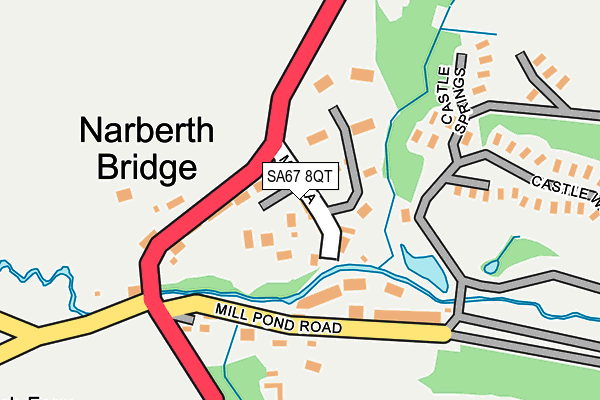
SA67 8QT lies on Mill Lane Cottages in Narberth. SA67 8QT is located in the Narberth: Urban electoral ward, within the unitary authority of Pembrokeshire and the Welsh Parliamentary constituency of Carmarthen West and South Pembrokeshire. The Local Health Board is Hywel Dda University and the police force is Dyfed-Powys. This postcode has been in use since January 1980.


GetTheData
Source: OS OpenMap – Local (Ordnance Survey)
Source: OS VectorMap District (Ordnance Survey)
Licence: Open Government Licence (requires attribution)
| Easting | 210883 |
| Northing | 214184 |
| Latitude | 51.794261 |
| Longitude | -4.743821 |
GetTheData
Source: Open Postcode Geo
Licence: Open Government Licence
| Street | Mill Lane Cottages |
| Town/City | Narberth |
| Country | Wales |
| Postcode District | SA67 |
➜ See where SA67 is on a map ➜ Where is Narberth? | |
GetTheData
Source: Land Registry Price Paid Data
Licence: Open Government Licence
Elevation or altitude of SA67 8QT as distance above sea level:
| Metres | Feet | |
|---|---|---|
| Elevation | 40m | 131ft |
Elevation is measured from the approximate centre of the postcode, to the nearest point on an OS contour line from OS Terrain 50, which has contour spacing of ten vertical metres.
➜ How high above sea level am I? Find the elevation of your current position using your device's GPS.
GetTheData
Source: Open Postcode Elevation
Licence: Open Government Licence
| Ward | Narberth: Urban |
| Constituency | Carmarthen West And South Pembrokeshire |
GetTheData
Source: ONS Postcode Database
Licence: Open Government Licence
3, MILL LANE COTTAGES, NARBERTH, SA67 8QT 1998 20 NOV £44,000 |
GetTheData
Source: HM Land Registry Price Paid Data
Licence: Contains HM Land Registry data © Crown copyright and database right 2025. This data is licensed under the Open Government Licence v3.0.
| Primary School (Moorfield Road) | Narberth | 627m |
| Farmers Arms (Northfield Road) | Narberth | 636m |
| Primary School (Moorfield Road) | Narberth | 638m |
| Farmers Arms (Northfield Road) | Narberth | 652m |
| Jesse Road (Jesse Road A478) | Narberth | 761m |
| Narberth Station | 1.3km |
GetTheData
Source: NaPTAN
Licence: Open Government Licence
GetTheData
Source: ONS Postcode Database
Licence: Open Government Licence


➜ Get more ratings from the Food Standards Agency
GetTheData
Source: Food Standards Agency
Licence: FSA terms & conditions
| Last Collection | |||
|---|---|---|---|
| Location | Mon-Fri | Sat | Distance |
| Narberth Bridge | 17:00 | 10:30 | 166m |
| Market Sq | 16:45 | 11:30 | 450m |
| Narberth Post Office | 17:15 | 12:30 | 550m |
GetTheData
Source: Dracos
Licence: Creative Commons Attribution-ShareAlike
The below table lists the International Territorial Level (ITL) codes (formerly Nomenclature of Territorial Units for Statistics (NUTS) codes) and Local Administrative Units (LAU) codes for SA67 8QT:
| ITL 1 Code | Name |
|---|---|
| TLL | Wales |
| ITL 2 Code | Name |
| TLL1 | West Wales and The Valleys |
| ITL 3 Code | Name |
| TLL14 | South West Wales |
| LAU 1 Code | Name |
| W06000009 | Pembrokeshire |
GetTheData
Source: ONS Postcode Directory
Licence: Open Government Licence
The below table lists the Census Output Area (OA), Lower Layer Super Output Area (LSOA), and Middle Layer Super Output Area (MSOA) for SA67 8QT:
| Code | Name | |
|---|---|---|
| OA | W00003191 | |
| LSOA | W01000595 | Pembrokeshire 007C |
| MSOA | W02000132 | Pembrokeshire 007 |
GetTheData
Source: ONS Postcode Directory
Licence: Open Government Licence
| SA67 8QS | Mill Lane | 10m |
| SA67 8QU | Mill Farm Cottages | 60m |
| SA67 8SW | Castlefield | 97m |
| SA67 8QR | Bridge Hill | 103m |
| SA67 8QX | Bridge Hill | 107m |
| SA67 8RA | Narberth Bridge Business Park | 138m |
| SA67 8QZ | The Bridge | 141m |
| SA67 8RB | 156m | |
| SA67 8QY | The Bridge | 185m |
| SA67 7BH | Church Street | 296m |
GetTheData
Source: Open Postcode Geo; Land Registry Price Paid Data
Licence: Open Government Licence