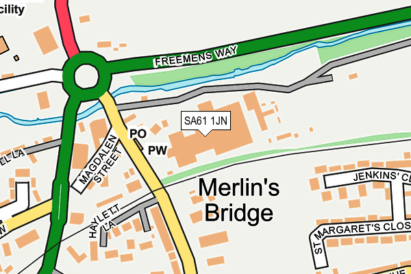
SA61 1JN is located in the Merlin's Bridge electoral ward, within the unitary authority of Pembrokeshire and the Welsh Parliamentary constituency of Preseli Pembrokeshire. The Local Health Board is Hywel Dda University and the police force is Dyfed-Powys. This postcode has been in use since January 1980.


GetTheData
Source: OS OpenMap – Local (Ordnance Survey)
Source: OS VectorMap District (Ordnance Survey)
Licence: Open Government Licence (requires attribution)
| Easting | 194881 |
| Northing | 214490 |
| Latitude | 51.791356 |
| Longitude | -4.975693 |
GetTheData
Source: Open Postcode Geo
Licence: Open Government Licence
| Country | Wales |
| Postcode District | SA61 |
➜ See where SA61 is on a map ➜ Where is Merlin's Bridge? | |
GetTheData
Source: Land Registry Price Paid Data
Licence: Open Government Licence
Elevation or altitude of SA61 1JN as distance above sea level:
| Metres | Feet | |
|---|---|---|
| Elevation | 20m | 66ft |
Elevation is measured from the approximate centre of the postcode, to the nearest point on an OS contour line from OS Terrain 50, which has contour spacing of ten vertical metres.
➜ How high above sea level am I? Find the elevation of your current position using your device's GPS.
GetTheData
Source: Open Postcode Elevation
Licence: Open Government Licence
| Ward | Merlin's Bridge |
| Constituency | Preseli Pembrokeshire |
GetTheData
Source: ONS Postcode Database
Licence: Open Government Licence
| Merlin's Bridge Post Office (Magdalen Street) | Merlin's Bridge | 134m |
| Merlin's Bridge Boxing Club (A4076) | Merlin's Bridge | 218m |
| Merlin's Bridge War Memorial (A4076) | Merlin's Bridge | 229m |
| Glen Hotel (Merlin`s Hill) | Merlin's Bridge | 252m |
| Merlin's Bridge Pembroke Road (Pembroke Road) | Merlin's Bridge | 256m |
| Haverfordwest Station | 1.6km |
| Johnston (Pembrokeshire) Station | 4.1km |
GetTheData
Source: NaPTAN
Licence: Open Government Licence
GetTheData
Source: ONS Postcode Database
Licence: Open Government Licence


➜ Get more ratings from the Food Standards Agency
GetTheData
Source: Food Standards Agency
Licence: FSA terms & conditions
| Last Collection | |||
|---|---|---|---|
| Location | Mon-Fri | Sat | Distance |
| Merlins Bridge P O | 17:15 | 12:15 | 117m |
| Haverfordwest Delivery Office | 18:00 | 13:00 | 249m |
| Old Hakin Road | 17:30 | 12:15 | 372m |
GetTheData
Source: Dracos
Licence: Creative Commons Attribution-ShareAlike
The below table lists the International Territorial Level (ITL) codes (formerly Nomenclature of Territorial Units for Statistics (NUTS) codes) and Local Administrative Units (LAU) codes for SA61 1JN:
| ITL 1 Code | Name |
|---|---|
| TLL | Wales |
| ITL 2 Code | Name |
| TLL1 | West Wales and The Valleys |
| ITL 3 Code | Name |
| TLL14 | South West Wales |
| LAU 1 Code | Name |
| W06000009 | Pembrokeshire |
GetTheData
Source: ONS Postcode Directory
Licence: Open Government Licence
The below table lists the Census Output Area (OA), Lower Layer Super Output Area (LSOA), and Middle Layer Super Output Area (MSOA) for SA61 1JN:
| Code | Name | |
|---|---|---|
| OA | W00003138 | |
| LSOA | W01000586 | Pembrokeshire 006C |
| MSOA | W02000131 | Pembrokeshire 006 |
GetTheData
Source: ONS Postcode Directory
Licence: Open Government Licence
| SA61 1JJ | Magdelene Street | 147m |
| SA61 1JW | Pembroke Road | 170m |
| SA61 1JP | Haylett Lane | 209m |
| SA61 1JL | Pembroke Road | 233m |
| SA61 1LH | Jenkins Close | 267m |
| SA61 1XB | Mill Lane | 268m |
| SA61 1JS | Merlins Avenue | 284m |
| SA61 1LD | St Margarets Close | 284m |
| SA61 1JU | St Issells Avenue | 289m |
| SA61 1JX | St Issells Avenue | 332m |
GetTheData
Source: Open Postcode Geo; Land Registry Price Paid Data
Licence: Open Government Licence