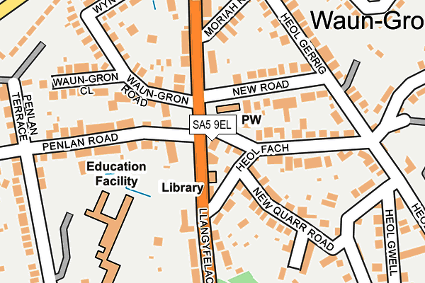
SA5 9EL lies on Llangyfelach Road in Treboeth, Swansea. SA5 9EL is located in the Mynydd-bach electoral ward, within the unitary authority of Swansea and the Welsh Parliamentary constituency of Swansea East. The Local Health Board is Swansea Bay University and the police force is South Wales. This postcode has been in use since January 1980.


GetTheData
Source: OS OpenMap – Local (Ordnance Survey)
Source: OS VectorMap District (Ordnance Survey)
Licence: Open Government Licence (requires attribution)
| Easting | 265250 |
| Northing | 196573 |
| Latitude | 51.651757 |
| Longitude | -3.949207 |
GetTheData
Source: Open Postcode Geo
Licence: Open Government Licence
| Street | Llangyfelach Road |
| Locality | Treboeth |
| Town/City | Swansea |
| Country | Wales |
| Postcode District | SA5 |
➜ See where SA5 is on a map ➜ Where is Swansea? | |
GetTheData
Source: Land Registry Price Paid Data
Licence: Open Government Licence
Elevation or altitude of SA5 9EL as distance above sea level:
| Metres | Feet | |
|---|---|---|
| Elevation | 100m | 328ft |
Elevation is measured from the approximate centre of the postcode, to the nearest point on an OS contour line from OS Terrain 50, which has contour spacing of ten vertical metres.
➜ How high above sea level am I? Find the elevation of your current position using your device's GPS.
GetTheData
Source: Open Postcode Elevation
Licence: Open Government Licence
| Ward | Mynydd-bach |
| Constituency | Swansea East |
GetTheData
Source: ONS Postcode Database
Licence: Open Government Licence
| Community Centre (Llangyfelach Road) | Treboeth | 45m |
| Community Centre (Llangyfelach Road) | Treboeth | 70m |
| Gwrosydd Primary School (Parkhill Terrace) | Treboeth | 206m |
| Penlan Primary School (Parkhill Terrace) | Treboeth | 206m |
| Gospel Hall (Heol Gwrosydd) | Treboeth | 288m |
| Swansea Station | 3km |
| Llansamlet Station | 4.6km |
GetTheData
Source: NaPTAN
Licence: Open Government Licence
| Percentage of properties with Next Generation Access | 64.8% |
| Percentage of properties with Superfast Broadband | 64.8% |
| Percentage of properties with Ultrafast Broadband | 59.3% |
| Percentage of properties with Full Fibre Broadband | 0.0% |
Superfast Broadband is between 30Mbps and 300Mbps
Ultrafast Broadband is > 300Mbps
| Median download speed | 80.0Mbps |
| Average download speed | 89.3Mbps |
| Maximum download speed | 350.00Mbps |
| Median upload speed | 11.9Mbps |
| Average upload speed | 11.4Mbps |
| Maximum upload speed | 20.00Mbps |
| Percentage of properties unable to receive 2Mbps | 0.0% |
| Percentage of properties unable to receive 5Mbps | 0.0% |
| Percentage of properties unable to receive 10Mbps | 0.0% |
| Percentage of properties unable to receive 30Mbps | 0.0% |
GetTheData
Source: Ofcom
Licence: Ofcom Terms of Use (requires attribution)
Estimated total energy consumption in SA5 9EL by fuel type, 2015.
| Consumption (kWh) | 560,765 |
|---|---|
| Meter count | 39 |
| Mean (kWh/meter) | 14,379 |
| Median (kWh/meter) | 12,643 |
| Consumption (kWh) | 106,850 |
|---|---|
| Meter count | 37 |
| Mean (kWh/meter) | 2,888 |
| Median (kWh/meter) | 2,519 |
GetTheData
Source: Postcode level gas estimates: 2015 (experimental)
Source: Postcode level electricity estimates: 2015 (experimental)
Licence: Open Government Licence
GetTheData
Source: ONS Postcode Database
Licence: Open Government Licence


➜ Get more ratings from the Food Standards Agency
GetTheData
Source: Food Standards Agency
Licence: FSA terms & conditions
| Last Collection | |||
|---|---|---|---|
| Location | Mon-Fri | Sat | Distance |
| Brynhyfryd P O | 18:15 | 12:30 | 809m |
| Mynydd Garnlwydd Road | 18:15 | 13:15 | 895m |
| Plasmarl P O | 18:30 | 11:30 | 1,125m |
GetTheData
Source: Dracos
Licence: Creative Commons Attribution-ShareAlike
The below table lists the International Territorial Level (ITL) codes (formerly Nomenclature of Territorial Units for Statistics (NUTS) codes) and Local Administrative Units (LAU) codes for SA5 9EL:
| ITL 1 Code | Name |
|---|---|
| TLL | Wales |
| ITL 2 Code | Name |
| TLL1 | West Wales and The Valleys |
| ITL 3 Code | Name |
| TLL18 | Swansea |
| LAU 1 Code | Name |
| W06000011 | Swansea |
GetTheData
Source: ONS Postcode Directory
Licence: Open Government Licence
The below table lists the Census Output Area (OA), Lower Layer Super Output Area (LSOA), and Middle Layer Super Output Area (MSOA) for SA5 9EL:
| Code | Name | |
|---|---|---|
| OA | W00004397 | |
| LSOA | W01000820 | Swansea 009D |
| MSOA | W02000176 | Swansea 009 |
GetTheData
Source: ONS Postcode Directory
Licence: Open Government Licence
| SA5 7DD | Penlan Road | 106m |
| SA5 7DG | Waun Gron Road | 137m |
| SA5 7DH | Waungron Close | 155m |
| SA5 9DE | Heol Fach | 158m |
| SA5 9DA | New Road | 177m |
| SA5 9BU | Moriah Road | 190m |
| SA5 9DH | New Quarr Road | 197m |
| SA5 9EN | Llangyfelach Road | 201m |
| SA5 7DB | Penlan Terrace | 233m |
| SA5 7DS | Wynter Court | 235m |
GetTheData
Source: Open Postcode Geo; Land Registry Price Paid Data
Licence: Open Government Licence