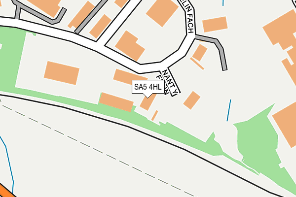
SA5 4HL is located in the Cockett electoral ward, within the unitary authority of Swansea and the Welsh Parliamentary constituency of Swansea West. The Local Health Board is Swansea Bay University and the police force is South Wales. This postcode has been in use since January 2010.


GetTheData
Source: OS OpenMap – Local (Ordnance Survey)
Source: OS VectorMap District (Ordnance Survey)
Licence: Open Government Licence (requires attribution)
| Easting | 262327 |
| Northing | 195485 |
| Latitude | 51.641272 |
| Longitude | -3.991003 |
GetTheData
Source: Open Postcode Geo
Licence: Open Government Licence
| Country | Wales |
| Postcode District | SA5 |
➜ See where SA5 is on a map ➜ Where is Swansea? | |
GetTheData
Source: Land Registry Price Paid Data
Licence: Open Government Licence
Elevation or altitude of SA5 4HL as distance above sea level:
| Metres | Feet | |
|---|---|---|
| Elevation | 60m | 197ft |
Elevation is measured from the approximate centre of the postcode, to the nearest point on an OS contour line from OS Terrain 50, which has contour spacing of ten vertical metres.
➜ How high above sea level am I? Find the elevation of your current position using your device's GPS.
GetTheData
Source: Open Postcode Elevation
Licence: Open Government Licence
| Ward | Cockett |
| Constituency | Swansea West |
GetTheData
Source: ONS Postcode Database
Licence: Open Government Licence
| Woodlands (Cwmbach Road) | Waunarlwydd | 496m |
| Woodlands (Cwmbach Road) | Waunarlwydd | 498m |
| Queensway (Kingsway) | Fforestfach | 505m |
| Dewhurst (Kingsway) | Fforestfach | 516m |
| Fforest-fach Dewhurst (Kingsway) | Fforestfach | 525m |
| Gowerton Station | 3.2km |
| Swansea Station | 3.9km |
GetTheData
Source: NaPTAN
Licence: Open Government Licence
GetTheData
Source: ONS Postcode Database
Licence: Open Government Licence


➜ Get more ratings from the Food Standards Agency
GetTheData
Source: Food Standards Agency
Licence: FSA terms & conditions
| Last Collection | |||
|---|---|---|---|
| Location | Mon-Fri | Sat | Distance |
| Middle Road (Lower) | 17:30 | 13:00 | 947m |
| Mynydd Bach Y Glo | 17:45 | 11:45 | 949m |
| Ystrad Road P O | 17:30 | 12:00 | 1,006m |
GetTheData
Source: Dracos
Licence: Creative Commons Attribution-ShareAlike
The below table lists the International Territorial Level (ITL) codes (formerly Nomenclature of Territorial Units for Statistics (NUTS) codes) and Local Administrative Units (LAU) codes for SA5 4HL:
| ITL 1 Code | Name |
|---|---|
| TLL | Wales |
| ITL 2 Code | Name |
| TLL1 | West Wales and The Valleys |
| ITL 3 Code | Name |
| TLL18 | Swansea |
| LAU 1 Code | Name |
| W06000011 | Swansea |
GetTheData
Source: ONS Postcode Directory
Licence: Open Government Licence
The below table lists the Census Output Area (OA), Lower Layer Super Output Area (LSOA), and Middle Layer Super Output Area (MSOA) for SA5 4HL:
| Code | Name | |
|---|---|---|
| OA | W00004092 | |
| LSOA | W01000756 | Swansea 017B |
| MSOA | W02000184 | Swansea 017 |
GetTheData
Source: ONS Postcode Directory
Licence: Open Government Licence
| SA5 4HP | Felin Fach | 55m |
| SA5 4HH | Felin Fach | 204m |
| SA5 4HB | Jubilee Court | 261m |
| SA5 4QA | Cwmbach Road | 436m |
| SA5 4DN | Kingsway | 462m |
| SA5 4DL | Kingsway | 467m |
| SA5 4HN | Prydwen Road | 503m |
| SA5 4AX | Llwyn Bedw | 551m |
| SA5 5BT | Murrayfield Close | 559m |
| SA5 5AB | Mendip Close | 587m |
GetTheData
Source: Open Postcode Geo; Land Registry Price Paid Data
Licence: Open Government Licence