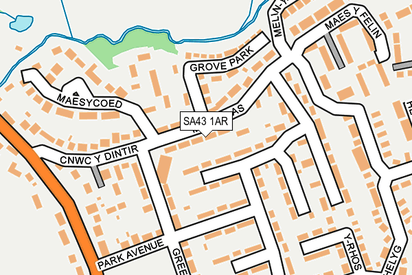
SA43 1AR lies on Maesglas in Cardigan. SA43 1AR is located in the Mwldan electoral ward, within the unitary authority of Ceredigion and the Welsh Parliamentary constituency of Ceredigion. The Local Health Board is Hywel Dda University and the police force is Dyfed-Powys. This postcode has been in use since January 1980.


GetTheData
Source: OS OpenMap – Local (Ordnance Survey)
Source: OS VectorMap District (Ordnance Survey)
Licence: Open Government Licence (requires attribution)
| Easting | 218335 |
| Northing | 246978 |
| Latitude | 52.091250 |
| Longitude | -4.653190 |
GetTheData
Source: Open Postcode Geo
Licence: Open Government Licence
| Street | Maesglas |
| Town/City | Cardigan |
| Country | Wales |
| Postcode District | SA43 |
➜ See where SA43 is on a map ➜ Where is Cardigan? | |
GetTheData
Source: Land Registry Price Paid Data
Licence: Open Government Licence
Elevation or altitude of SA43 1AR as distance above sea level:
| Metres | Feet | |
|---|---|---|
| Elevation | 30m | 98ft |
Elevation is measured from the approximate centre of the postcode, to the nearest point on an OS contour line from OS Terrain 50, which has contour spacing of ten vertical metres.
➜ How high above sea level am I? Find the elevation of your current position using your device's GPS.
GetTheData
Source: Open Postcode Elevation
Licence: Open Government Licence
| Ward | Mwldan |
| Constituency | Ceredigion |
GetTheData
Source: ONS Postcode Database
Licence: Open Government Licence
| Hawthorns (Maesglas) | Cardigan | 71m |
| Hawthorns (Maesglas) | Cardigan | 71m |
| Felin Ban (Maesglas) | Cardigan | 171m |
| Maesglas Estate (Maesglas) | Cardigan | 206m |
| Brondesbury Lodge (Heol Helyg) | Cardigan | 269m |
GetTheData
Source: NaPTAN
Licence: Open Government Licence
| Percentage of properties with Next Generation Access | 100.0% |
| Percentage of properties with Superfast Broadband | 100.0% |
| Percentage of properties with Ultrafast Broadband | 0.0% |
| Percentage of properties with Full Fibre Broadband | 0.0% |
Superfast Broadband is between 30Mbps and 300Mbps
Ultrafast Broadband is > 300Mbps
| Percentage of properties unable to receive 2Mbps | 0.0% |
| Percentage of properties unable to receive 5Mbps | 0.0% |
| Percentage of properties unable to receive 10Mbps | 0.0% |
| Percentage of properties unable to receive 30Mbps | 0.0% |
GetTheData
Source: Ofcom
Licence: Ofcom Terms of Use (requires attribution)
Estimated total energy consumption in SA43 1AR by fuel type, 2015.
| Consumption (kWh) | 101,317 |
|---|---|
| Meter count | 12 |
| Mean (kWh/meter) | 8,443 |
| Median (kWh/meter) | 6,827 |
| Consumption (kWh) | 27,001 |
|---|---|
| Meter count | 11 |
| Mean (kWh/meter) | 2,455 |
| Median (kWh/meter) | 1,936 |
GetTheData
Source: Postcode level gas estimates: 2015 (experimental)
Source: Postcode level electricity estimates: 2015 (experimental)
Licence: Open Government Licence
GetTheData
Source: ONS Postcode Database
Licence: Open Government Licence


➜ Get more ratings from the Food Standards Agency
GetTheData
Source: Food Standards Agency
Licence: FSA terms & conditions
| Last Collection | |||
|---|---|---|---|
| Location | Mon-Fri | Sat | Distance |
| Tesco | 16:00 | 12:00 | 440m |
| Feidr Fair (Mapstone) | 16:30 | 12:30 | 783m |
| Cardigan Delivery Office | 17:15 | 13:00 | 1,259m |
GetTheData
Source: Dracos
Licence: Creative Commons Attribution-ShareAlike
The below table lists the International Territorial Level (ITL) codes (formerly Nomenclature of Territorial Units for Statistics (NUTS) codes) and Local Administrative Units (LAU) codes for SA43 1AR:
| ITL 1 Code | Name |
|---|---|
| TLL | Wales |
| ITL 2 Code | Name |
| TLL1 | West Wales and The Valleys |
| ITL 3 Code | Name |
| TLL14 | South West Wales |
| LAU 1 Code | Name |
| W06000008 | Ceredigion |
GetTheData
Source: ONS Postcode Directory
Licence: Open Government Licence
The below table lists the Census Output Area (OA), Lower Layer Super Output Area (LSOA), and Middle Layer Super Output Area (MSOA) for SA43 1AR:
| Code | Name | |
|---|---|---|
| OA | W00002725 | |
| LSOA | W01000509 | Ceredigion 009C |
| MSOA | W02000124 | Ceredigion 009 |
GetTheData
Source: ONS Postcode Directory
Licence: Open Government Licence
| SA43 1BD | Maesglas | 38m |
| SA43 1AT | Maesglas | 45m |
| SA43 1AQ | Maesglas | 87m |
| SA43 1AS | Maesglas | 103m |
| SA43 1BE | Maesglas | 105m |
| SA43 1AU | Rhyd Y Felin | 113m |
| SA43 1AX | Grove Park | 122m |
| SA43 1AH | Greenland Meadows | 128m |
| SA43 1AY | Maesglas | 131m |
| SA43 1BA | Cnwc Y Dintir | 154m |
GetTheData
Source: Open Postcode Geo; Land Registry Price Paid Data
Licence: Open Government Licence