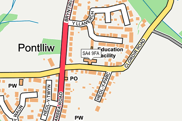
SA4 9FA is located in the Pontlliw and Tircoed electoral ward, within the unitary authority of Swansea and the Welsh Parliamentary constituency of Gower. The Local Health Board is Swansea Bay University and the police force is South Wales. This postcode has been in use since June 2002.


GetTheData
Source: OS OpenMap – Local (Ordnance Survey)
Source: OS VectorMap District (Ordnance Survey)
Licence: Open Government Licence (requires attribution)
| Easting | 261136 |
| Northing | 201299 |
| Latitude | 51.693216 |
| Longitude | -4.010497 |
GetTheData
Source: Open Postcode Geo
Licence: Open Government Licence
| Country | Wales |
| Postcode District | SA4 |
➜ See where SA4 is on a map ➜ Where is Pontlliw? | |
GetTheData
Source: Land Registry Price Paid Data
Licence: Open Government Licence
Elevation or altitude of SA4 9FA as distance above sea level:
| Metres | Feet | |
|---|---|---|
| Elevation | 50m | 164ft |
Elevation is measured from the approximate centre of the postcode, to the nearest point on an OS contour line from OS Terrain 50, which has contour spacing of ten vertical metres.
➜ How high above sea level am I? Find the elevation of your current position using your device's GPS.
GetTheData
Source: Open Postcode Elevation
Licence: Open Government Licence
| Ward | Pontlliw And Tircoed |
| Constituency | Gower |
GetTheData
Source: ONS Postcode Database
Licence: Open Government Licence
| Y Llanerch (Bryntirion Road) | Pont Lliw | 165m |
| Y Llanerch (Bryntirion Road) | Pont Lliw | 189m |
| Post Office (Swansea Road) | Pont Lliw | 249m |
| Post Office (Swansea Road) | Pont Lliw | 298m |
| Oaklands Road (Swansea Road) | Pont Lliw | 813m |
| Pontarddulais Station | 3.6km |
| Llangennech Station | 4.7km |
| Gowerton Station | 5.3km |
GetTheData
Source: NaPTAN
Licence: Open Government Licence
GetTheData
Source: ONS Postcode Database
Licence: Open Government Licence


➜ Get more ratings from the Food Standards Agency
GetTheData
Source: Food Standards Agency
Licence: FSA terms & conditions
| Last Collection | |||
|---|---|---|---|
| Location | Mon-Fri | Sat | Distance |
| Pontlliw P O | 17:30 | 12:30 | 107m |
| Swansea Road | 17:30 | 11:15 | 891m |
| Cwmanllech | 18:00 | 13:00 | 1,310m |
GetTheData
Source: Dracos
Licence: Creative Commons Attribution-ShareAlike
The below table lists the International Territorial Level (ITL) codes (formerly Nomenclature of Territorial Units for Statistics (NUTS) codes) and Local Administrative Units (LAU) codes for SA4 9FA:
| ITL 1 Code | Name |
|---|---|
| TLL | Wales |
| ITL 2 Code | Name |
| TLL1 | West Wales and The Valleys |
| ITL 3 Code | Name |
| TLL18 | Swansea |
| LAU 1 Code | Name |
| W06000011 | Swansea |
GetTheData
Source: ONS Postcode Directory
Licence: Open Government Licence
The below table lists the Census Output Area (OA), Lower Layer Super Output Area (LSOA), and Middle Layer Super Output Area (MSOA) for SA4 9FA:
| Code | Name | |
|---|---|---|
| OA | W00004255 | |
| LSOA | W01000792 | Swansea 004B |
| MSOA | W02000171 | Swansea 004 |
GetTheData
Source: ONS Postcode Directory
Licence: Open Government Licence
| SA4 9EY | Clordir Road | 66m |
| SA4 9EZ | Heol Y Parc | 109m |
| SA4 9DR | Y Llanerch | 126m |
| SA4 9EB | Bryntirion Road | 181m |
| SA4 9EU | Heol Y Twyn | 204m |
| SA4 9EE | Swansea Road | 209m |
| SA4 9ED | Bryn Road | 240m |
| SA4 9EL | Heol Y Waun | 253m |
| SA4 9EW | Heol Y Waun | 344m |
| SA4 9EX | Carmel Road | 350m |
GetTheData
Source: Open Postcode Geo; Land Registry Price Paid Data
Licence: Open Government Licence