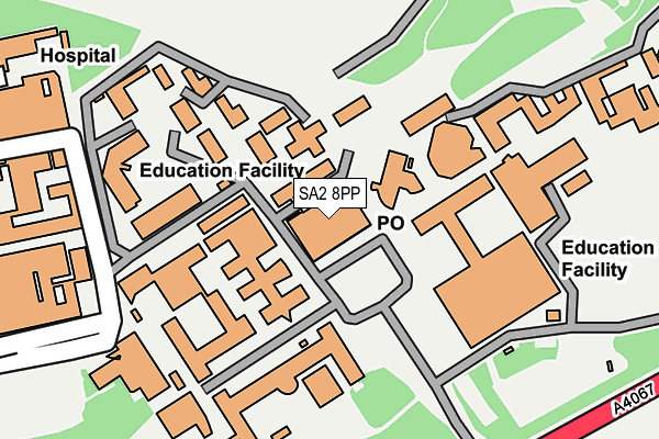
SA2 8PP is located in the Sketty electoral ward, within the unitary authority of Swansea and the Welsh Parliamentary constituency of Swansea West. The Local Health Board is Swansea Bay University and the police force is South Wales. This postcode has been in use since January 1980.


GetTheData
Source: OS OpenMap – Local (Ordnance Survey)
Source: OS VectorMap District (Ordnance Survey)
Licence: Open Government Licence (requires attribution)
| Easting | 262949 |
| Northing | 191947 |
| Latitude | 51.609627 |
| Longitude | -3.980616 |
GetTheData
Source: Open Postcode Geo
Licence: Open Government Licence
| Country | Wales |
| Postcode District | SA2 |
➜ See where SA2 is on a map ➜ Where is Swansea? | |
GetTheData
Source: Land Registry Price Paid Data
Licence: Open Government Licence
Elevation or altitude of SA2 8PP as distance above sea level:
| Metres | Feet | |
|---|---|---|
| Elevation | 20m | 66ft |
Elevation is measured from the approximate centre of the postcode, to the nearest point on an OS contour line from OS Terrain 50, which has contour spacing of ten vertical metres.
➜ How high above sea level am I? Find the elevation of your current position using your device's GPS.
GetTheData
Source: Open Postcode Elevation
Licence: Open Government Licence
| Ward | Sketty |
| Constituency | Swansea West |
GetTheData
Source: ONS Postcode Database
Licence: Open Government Licence
| Swansea University Campus (Grounds) | Singleton | 40m |
| Swansea University Campus (Grounds) | Singleton | 64m |
| Hospital (Grounds) | Singleton | 272m |
| Swansea University (Mumbles Road) | Singleton | 274m |
| Boating Lake (Mumbles Road) | Singleton | 305m |
| Swansea Station | 3.2km |
| Gowerton Station | 5.8km |
GetTheData
Source: NaPTAN
Licence: Open Government Licence
GetTheData
Source: ONS Postcode Database
Licence: Open Government Licence


➜ Get more ratings from the Food Standards Agency
GetTheData
Source: Food Standards Agency
Licence: FSA terms & conditions
| Last Collection | |||
|---|---|---|---|
| Location | Mon-Fri | Sat | Distance |
| Swansea University P O | 18:15 | 13:45 | 34m |
| Oakwood Road | 17:45 | 13:30 | 707m |
| Glanbrydan Avenue | 18:00 | 12:45 | 889m |
GetTheData
Source: Dracos
Licence: Creative Commons Attribution-ShareAlike
The below table lists the International Territorial Level (ITL) codes (formerly Nomenclature of Territorial Units for Statistics (NUTS) codes) and Local Administrative Units (LAU) codes for SA2 8PP:
| ITL 1 Code | Name |
|---|---|
| TLL | Wales |
| ITL 2 Code | Name |
| TLL1 | West Wales and The Valleys |
| ITL 3 Code | Name |
| TLL18 | Swansea |
| LAU 1 Code | Name |
| W06000011 | Swansea |
GetTheData
Source: ONS Postcode Directory
Licence: Open Government Licence
The below table lists the Census Output Area (OA), Lower Layer Super Output Area (LSOA), and Middle Layer Super Output Area (MSOA) for SA2 8PP:
| Code | Name | |
|---|---|---|
| OA | W00010073 | |
| LSOA | W01000861 | Swansea 027D |
| MSOA | W02000194 | Swansea 027 |
GetTheData
Source: ONS Postcode Directory
Licence: Open Government Licence
| SA2 8QD | Singleton Park | 412m |
| SA2 8PY | Singleton Park | 473m |
| SA2 0BA | Brynmill Terrace | 517m |
| SA2 0BB | Langland Terrace | 547m |
| SA2 0AU | Bryn Road | 561m |
| SA2 0DB | Chesshyre Street | 576m |
| SA2 0BD | Malvern Terrace | 577m |
| SA2 0AT | Bryn Road | 602m |
| SA2 0DA | Penbryn Terrace | 613m |
| SA2 0DD | Canterbury Road | 620m |
GetTheData
Source: Open Postcode Geo; Land Registry Price Paid Data
Licence: Open Government Licence