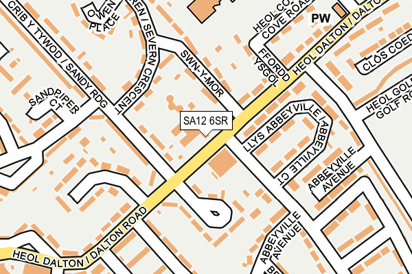
SA12 6SR is located in the Sandfields East electoral ward, within the unitary authority of Neath Port Talbot and the Welsh Parliamentary constituency of Aberavon. The Local Health Board is Swansea Bay University and the police force is South Wales. This postcode has been in use since July 2017.


GetTheData
Source: OS OpenMap – Local (Ordnance Survey)
Source: OS VectorMap District (Ordnance Survey)
Licence: Open Government Licence (requires attribution)
| Easting | 274603 |
| Northing | 190104 |
| Latitude | 51.595786 |
| Longitude | -3.811767 |
GetTheData
Source: Open Postcode Geo
Licence: Open Government Licence
| Country | Wales |
| Postcode District | SA12 |
➜ See where SA12 is on a map ➜ Where is Port Talbot? | |
GetTheData
Source: Land Registry Price Paid Data
Licence: Open Government Licence
| Ward | Sandfields East |
| Constituency | Aberavon |
GetTheData
Source: ONS Postcode Database
Licence: Open Government Licence
| Seaside Social Club (Dalton Road) | Aberavon | 39m |
| Sandy Ridge | Sandfields | 83m |
| Romney Road | Aberavon | 127m |
| Dalton House (Dalton Road) | Sandfields | 133m |
| Romney Road | Aberavon | 135m |
| Port Talbot Parkway Station | 2.2km |
| Baglan Station | 2.2km |
| Briton Ferry Station | 4.7km |
GetTheData
Source: NaPTAN
Licence: Open Government Licence
| Percentage of properties with Next Generation Access | 100.0% |
| Percentage of properties with Superfast Broadband | 100.0% |
| Percentage of properties with Ultrafast Broadband | 0.0% |
| Percentage of properties with Full Fibre Broadband | 0.0% |
Superfast Broadband is between 30Mbps and 300Mbps
Ultrafast Broadband is > 300Mbps
| Median download speed | 63.0Mbps |
| Average download speed | 47.4Mbps |
| Maximum download speed | 78.11Mbps |
| Median upload speed | 18.3Mbps |
| Average upload speed | 12.5Mbps |
| Maximum upload speed | 20.00Mbps |
| Percentage of properties unable to receive 2Mbps | 0.0% |
| Percentage of properties unable to receive 5Mbps | 0.0% |
| Percentage of properties unable to receive 10Mbps | 0.0% |
| Percentage of properties unable to receive 30Mbps | 0.0% |
GetTheData
Source: Ofcom
Licence: Ofcom Terms of Use (requires attribution)
GetTheData
Source: ONS Postcode Database
Licence: Open Government Licence


➜ Get more ratings from the Food Standards Agency
GetTheData
Source: Food Standards Agency
Licence: FSA terms & conditions
| Last Collection | |||
|---|---|---|---|
| Location | Mon-Fri | Sat | Distance |
| Tanygroes Street Post Office | 17:45 | 11:30 | 2,205m |
| Sunny Croft Road | 17:30 | 07:30 | 2,305m |
| Mayberry Road Post Office | 17:30 | 11:30 | 3,155m |
GetTheData
Source: Dracos
Licence: Creative Commons Attribution-ShareAlike
The below table lists the International Territorial Level (ITL) codes (formerly Nomenclature of Territorial Units for Statistics (NUTS) codes) and Local Administrative Units (LAU) codes for SA12 6SR:
| ITL 1 Code | Name |
|---|---|
| TLL | Wales |
| ITL 2 Code | Name |
| TLL1 | West Wales and The Valleys |
| ITL 3 Code | Name |
| TLL17 | Bridgend and Neath Port Talbot |
| LAU 1 Code | Name |
| W06000012 | Neath Port Talbot |
GetTheData
Source: ONS Postcode Directory
Licence: Open Government Licence
The below table lists the Census Output Area (OA), Lower Layer Super Output Area (LSOA), and Middle Layer Super Output Area (MSOA) for SA12 6SR:
| Code | Name | |
|---|---|---|
| OA | W00005080 | |
| LSOA | W01000957 | Neath Port Talbot 017D |
| MSOA | W02000215 | Neath Port Talbot 017 |
GetTheData
Source: ONS Postcode Directory
Licence: Open Government Licence
| SA12 6SN | Dalton Road | 54m |
| SA12 6SY | Severn Crescent | 81m |
| SA12 6TB | Swn Y Mor | 100m |
| SA12 6SL | Dalton Road | 104m |
| SA12 6SS | Dalton Close | 108m |
| SA12 6TP | Ffordd Ysgol | 147m |
| SA12 6SU | Sandy Ridge | 155m |
| SA12 6ST | Sandy Close | 156m |
| SA12 6RF | Abbeyville Court | 157m |
| SA12 6RG | Abbeyville Avenue | 177m |
GetTheData
Source: Open Postcode Geo; Land Registry Price Paid Data
Licence: Open Government Licence