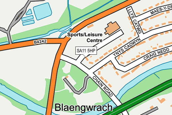
SA11 5HP lies on Chain Road in Glynneath, Neath. SA11 5HP is located in the Blaengwrach and Glynneath West electoral ward, within the unitary authority of Neath Port Talbot and the Welsh Parliamentary constituency of Neath. The Local Health Board is Swansea Bay University and the police force is South Wales. This postcode has been in use since January 1980.


GetTheData
Source: OS OpenMap – Local (Ordnance Survey)
Source: OS VectorMap District (Ordnance Survey)
Licence: Open Government Licence (requires attribution)
| Easting | 286899 |
| Northing | 205839 |
| Latitude | 51.739807 |
| Longitude | -3.639414 |
GetTheData
Source: Open Postcode Geo
Licence: Open Government Licence
| Street | Chain Road |
| Locality | Glynneath |
| Town/City | Neath |
| Country | Wales |
| Postcode District | SA11 |
➜ See where SA11 is on a map ➜ Where is Glyn-neath? | |
GetTheData
Source: Land Registry Price Paid Data
Licence: Open Government Licence
Elevation or altitude of SA11 5HP as distance above sea level:
| Metres | Feet | |
|---|---|---|
| Elevation | 50m | 164ft |
Elevation is measured from the approximate centre of the postcode, to the nearest point on an OS contour line from OS Terrain 50, which has contour spacing of ten vertical metres.
➜ How high above sea level am I? Find the elevation of your current position using your device's GPS.
GetTheData
Source: Open Postcode Elevation
Licence: Open Government Licence
| Ward | Blaengwrach And Glynneath West |
| Constituency | Neath |
GetTheData
Source: ONS Postcode Database
Licence: Open Government Licence
| Chain Road (B4242) | Aberpergwm | 106m |
| Chain Road (B4242) | Aberpergwm | 117m |
| Cwmgwrach Roundabout (Chain Road) | Blaengwrach | 387m |
| Cwmgwrach High Street (High Street) | Blaengwrach | 402m |
| Nant Hir | Morfa Glas | 489m |
GetTheData
Source: NaPTAN
Licence: Open Government Licence
| Percentage of properties with Next Generation Access | 100.0% |
| Percentage of properties with Superfast Broadband | 100.0% |
| Percentage of properties with Ultrafast Broadband | 0.0% |
| Percentage of properties with Full Fibre Broadband | 0.0% |
Superfast Broadband is between 30Mbps and 300Mbps
Ultrafast Broadband is > 300Mbps
| Percentage of properties unable to receive 2Mbps | 0.0% |
| Percentage of properties unable to receive 5Mbps | 0.0% |
| Percentage of properties unable to receive 10Mbps | 0.0% |
| Percentage of properties unable to receive 30Mbps | 0.0% |
GetTheData
Source: Ofcom
Licence: Ofcom Terms of Use (requires attribution)
GetTheData
Source: ONS Postcode Database
Licence: Open Government Licence


➜ Get more ratings from the Food Standards Agency
GetTheData
Source: Food Standards Agency
Licence: FSA terms & conditions
| Last Collection | |||
|---|---|---|---|
| Location | Mon-Fri | Sat | Distance |
| Pencomen | 16:30 | 11:00 | 3,875m |
GetTheData
Source: Dracos
Licence: Creative Commons Attribution-ShareAlike
The below table lists the International Territorial Level (ITL) codes (formerly Nomenclature of Territorial Units for Statistics (NUTS) codes) and Local Administrative Units (LAU) codes for SA11 5HP:
| ITL 1 Code | Name |
|---|---|
| TLL | Wales |
| ITL 2 Code | Name |
| TLL1 | West Wales and The Valleys |
| ITL 3 Code | Name |
| TLL17 | Bridgend and Neath Port Talbot |
| LAU 1 Code | Name |
| W06000012 | Neath Port Talbot |
GetTheData
Source: ONS Postcode Directory
Licence: Open Government Licence
The below table lists the Census Output Area (OA), Lower Layer Super Output Area (LSOA), and Middle Layer Super Output Area (MSOA) for SA11 5HP:
| Code | Name | |
|---|---|---|
| OA | W00004765 | |
| LSOA | W01000893 | Neath Port Talbot 003A |
| MSOA | W02000201 | Neath Port Talbot 003 |
GetTheData
Source: ONS Postcode Directory
Licence: Open Government Licence
| SA11 5HW | Chain Road | 103m |
| SA11 5HN | Ynys Cadwyn | 184m |
| SA11 5HL | Llys Catwg | 200m |
| SA11 5HG | Craig Nedd | 226m |
| SA11 5SN | St Marys Close | 306m |
| SA11 5HH | Maes Y Dre | 330m |
| SA11 5SL | Church Crescent | 331m |
| SA11 5ST | Empire Avenue | 392m |
| SA11 5RG | 394m | |
| SA11 5RE | Manor Drive | 403m |
GetTheData
Source: Open Postcode Geo; Land Registry Price Paid Data
Licence: Open Government Licence