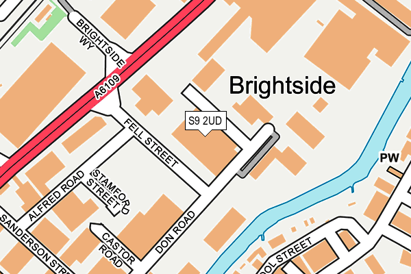
S9 2UD is located in the Darnall electoral ward, within the metropolitan district of Sheffield and the English Parliamentary constituency of Sheffield South East. The Sub Integrated Care Board (ICB) Location is NHS South Yorkshire ICB - 03N and the police force is South Yorkshire. This postcode has been in use since December 1996.


GetTheData
Source: OS OpenMap – Local (Ordnance Survey)
Source: OS VectorMap District (Ordnance Survey)
Licence: Open Government Licence (requires attribution)
| Easting | 437948 |
| Northing | 389528 |
| Latitude | 53.401237 |
| Longitude | -1.430717 |
GetTheData
Source: Open Postcode Geo
Licence: Open Government Licence
| Country | England |
| Postcode District | S9 |
➜ See where S9 is on a map ➜ Where is Sheffield? | |
GetTheData
Source: Land Registry Price Paid Data
Licence: Open Government Licence
Elevation or altitude of S9 2UD as distance above sea level:
| Metres | Feet | |
|---|---|---|
| Elevation | 40m | 131ft |
Elevation is measured from the approximate centre of the postcode, to the nearest point on an OS contour line from OS Terrain 50, which has contour spacing of ten vertical metres.
➜ How high above sea level am I? Find the elevation of your current position using your device's GPS.
GetTheData
Source: Open Postcode Elevation
Licence: Open Government Licence
| Ward | Darnall |
| Constituency | Sheffield South East |
GetTheData
Source: ONS Postcode Database
Licence: Open Government Licence
| Fell Street (Brightside Lane) | Brightside | 156m |
| Fell Street (Brightside Lane) | Brightside | 197m |
| Upwell Street (Brightside Lane) | Brightside | 343m |
| Hawke Street (Brightside Lane) | Brightside | 345m |
| Newhall Road (Brightside Lane) | Brightside | 349m |
| Arena - Don Valley (Sheffield Supertram) (Off Coleridge Road) | Don Valley | 758m |
| Attercliffe (Sheffield Supertram) (Shortridge Street) | Attercliffe | 994m |
| Valley Centertainment (Sheffield Supertram) (Off Greenland Road) | Carbrook | 1,205m |
| Woodbourn Road (Sheffield Supertram) (Woodbourn Road) | Attercliffe | 1,399m |
| Carbrook (Sheffield Supertram) (Off Sheffield Road - Attercliffe Road) | Carbrook | 1,406m |
| Meadowhall Station | 2.2km |
| Darnall Station | 2.2km |
| Sheffield Station | 3.3km |
GetTheData
Source: NaPTAN
Licence: Open Government Licence
GetTheData
Source: ONS Postcode Database
Licence: Open Government Licence


➜ Get more ratings from the Food Standards Agency
GetTheData
Source: Food Standards Agency
Licence: FSA terms & conditions
| Last Collection | |||
|---|---|---|---|
| Location | Mon-Fri | Sat | Distance |
| Sanderson Street | 18:30 | 11:00 | 265m |
| Sanderson Street | 18:30 | 274m | |
| Sheffield Mail Centre | 19:30 | 13:00 | 379m |
GetTheData
Source: Dracos
Licence: Creative Commons Attribution-ShareAlike
| Risk of S9 2UD flooding from rivers and sea | High |
| ➜ S9 2UD flood map | |
GetTheData
Source: Open Flood Risk by Postcode
Licence: Open Government Licence
The below table lists the International Territorial Level (ITL) codes (formerly Nomenclature of Territorial Units for Statistics (NUTS) codes) and Local Administrative Units (LAU) codes for S9 2UD:
| ITL 1 Code | Name |
|---|---|
| TLE | Yorkshire and The Humber |
| ITL 2 Code | Name |
| TLE3 | South Yorkshire |
| ITL 3 Code | Name |
| TLE32 | Sheffield |
| LAU 1 Code | Name |
| E08000019 | Sheffield |
GetTheData
Source: ONS Postcode Directory
Licence: Open Government Licence
The below table lists the Census Output Area (OA), Lower Layer Super Output Area (LSOA), and Middle Layer Super Output Area (MSOA) for S9 2UD:
| Code | Name | |
|---|---|---|
| OA | E00172428 | |
| LSOA | E01033269 | Sheffield 022G |
| MSOA | E02001632 | Sheffield 022 |
GetTheData
Source: ONS Postcode Directory
Licence: Open Government Licence
| S9 2PR | Leigh Street | 290m |
| S9 2LR | Bold Street | 316m |
| S9 2PA | Brompton Road | 334m |
| S9 2LQ | Amberley Court | 336m |
| S9 2QJ | Newhall Road | 379m |
| S9 2RS | Brightside Lane | 380m |
| S9 2AE | Attercliffe Common | 404m |
| S9 2QL | Newhall Road | 430m |
| S9 2SP | Brightside Lane | 431m |
| S4 8DG | Bland Street | 548m |
GetTheData
Source: Open Postcode Geo; Land Registry Price Paid Data
Licence: Open Government Licence