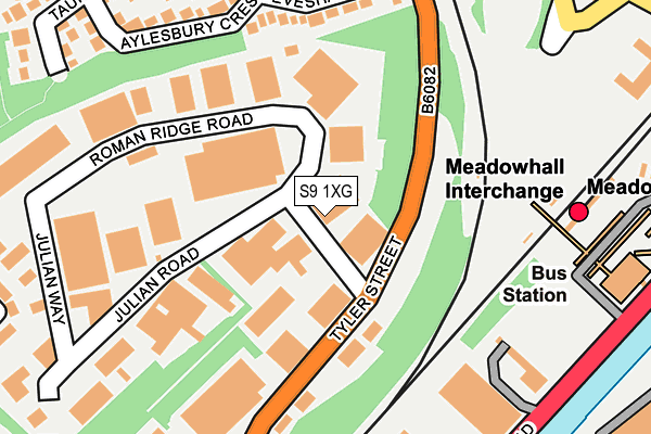
S9 1XG is located in the Shiregreen and Brightside electoral ward, within the metropolitan district of Sheffield and the English Parliamentary constituency of Sheffield, Brightside and Hillsborough. The Sub Integrated Care Board (ICB) Location is NHS South Yorkshire ICB - 03N and the police force is South Yorkshire. This postcode has been in use since February 1990.


GetTheData
Source: OS OpenMap – Local (Ordnance Survey)
Source: OS VectorMap District (Ordnance Survey)
Licence: Open Government Licence (requires attribution)
| Easting | 438845 |
| Northing | 391276 |
| Latitude | 53.416865 |
| Longitude | -1.417012 |
GetTheData
Source: Open Postcode Geo
Licence: Open Government Licence
| Country | England |
| Postcode District | S9 |
➜ See where S9 is on a map ➜ Where is Sheffield? | |
GetTheData
Source: Land Registry Price Paid Data
Licence: Open Government Licence
Elevation or altitude of S9 1XG as distance above sea level:
| Metres | Feet | |
|---|---|---|
| Elevation | 70m | 230ft |
Elevation is measured from the approximate centre of the postcode, to the nearest point on an OS contour line from OS Terrain 50, which has contour spacing of ten vertical metres.
➜ How high above sea level am I? Find the elevation of your current position using your device's GPS.
GetTheData
Source: Open Postcode Elevation
Licence: Open Government Licence
| Ward | Shiregreen And Brightside |
| Constituency | Sheffield, Brightside And Hillsborough |
GetTheData
Source: ONS Postcode Database
Licence: Open Government Licence
| Meadowhall Interchange (Meadowhall Road) | Meadowhall | 256m |
| Trade Centre (Meadowhall Road) | Meadowhall | 298m |
| Trade Centre (Meadowhall Road) | Meadowhall | 320m |
| Hayland Street (Meadowhall Road) | Meadowhall | 462m |
| Newman Road (Barrow Road) | Wincobank | 462m |
| Meadowhall Interchange (Sheffield Supertram) (Off Meadowhall Road) | Meadowhall | 292m |
| Meadowhall South - Tinsley (Sheffield Supertram) (Off Meadowhall Way) | Meadowhall | 851m |
| Carbrook (Sheffield Supertram) (Off Sheffield Road - Attercliffe Road) | Carbrook | 1,324m |
| Meadowhall Station | 0.3km |
| Darnall Station | 3.6km |
| Rotherham Central Station | 4.1km |
GetTheData
Source: NaPTAN
Licence: Open Government Licence
GetTheData
Source: ONS Postcode Database
Licence: Open Government Licence


➜ Get more ratings from the Food Standards Agency
GetTheData
Source: Food Standards Agency
Licence: FSA terms & conditions
| Last Collection | |||
|---|---|---|---|
| Location | Mon-Fri | Sat | Distance |
| Roman Ridge Road | 18:30 | 13:00 | 21m |
| Roman Ridge Road | 18:30 | 23m | |
| Meadowhall Interchange | 17:30 | 12:30 | 231m |
GetTheData
Source: Dracos
Licence: Creative Commons Attribution-ShareAlike
The below table lists the International Territorial Level (ITL) codes (formerly Nomenclature of Territorial Units for Statistics (NUTS) codes) and Local Administrative Units (LAU) codes for S9 1XG:
| ITL 1 Code | Name |
|---|---|
| TLE | Yorkshire and The Humber |
| ITL 2 Code | Name |
| TLE3 | South Yorkshire |
| ITL 3 Code | Name |
| TLE32 | Sheffield |
| LAU 1 Code | Name |
| E08000019 | Sheffield |
GetTheData
Source: ONS Postcode Directory
Licence: Open Government Licence
The below table lists the Census Output Area (OA), Lower Layer Super Output Area (LSOA), and Middle Layer Super Output Area (MSOA) for S9 1XG:
| Code | Name | |
|---|---|---|
| OA | E00039798 | |
| LSOA | E01007852 | Sheffield 014C |
| MSOA | E02001624 | Sheffield 014 |
GetTheData
Source: ONS Postcode Directory
Licence: Open Government Licence
| S9 1GB | Roman Ridge Road | 82m |
| S9 1JU | Evesham Close | 194m |
| S9 1FZ | Julian Road | 221m |
| S9 1JR | Aylesbury Crescent | 226m |
| S9 1JT | Taunton Grove | 262m |
| S9 1JB | Aylesbury Court | 282m |
| S9 1GD | Julian Way | 286m |
| S9 1JS | Taunton Avenue | 286m |
| S9 1DT | Tyler Way | 318m |
| S9 1DH | Tyler Street | 320m |
GetTheData
Source: Open Postcode Geo; Land Registry Price Paid Data
Licence: Open Government Licence