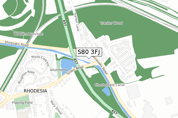
S80 3FJ is located in the Worksop North West electoral ward, within the local authority district of Bassetlaw and the English Parliamentary constituency of Bassetlaw. The Sub Integrated Care Board (ICB) Location is NHS Nottingham and Nottinghamshire ICB - 02Q and the police force is Nottinghamshire. This postcode has been in use since October 2017.


GetTheData
Source: OS Open Zoomstack (Ordnance Survey)
Licence: Open Government Licence (requires attribution)
Attribution: Contains OS data © Crown copyright and database right 2025
Source: Open Postcode Geo
Licence: Open Government Licence (requires attribution)
Attribution: Contains OS data © Crown copyright and database right 2025; Contains Royal Mail data © Royal Mail copyright and database right 2025; Source: Office for National Statistics licensed under the Open Government Licence v.3.0
| Easting | 456706 |
| Northing | 380231 |
| Latitude | 53.316004 |
| Longitude | -1.150284 |
GetTheData
Source: Open Postcode Geo
Licence: Open Government Licence
| Country | England |
| Postcode District | S80 |
➜ See where S80 is on a map | |
GetTheData
Source: Land Registry Price Paid Data
Licence: Open Government Licence
| Ward | Worksop North West |
| Constituency | Bassetlaw |
GetTheData
Source: ONS Postcode Database
Licence: Open Government Licence
| Tranker Lane (Shireoaks Road) | Rhodesia | 61m |
| Tranker Lane (Shireoaks Road) | Rhodesia | 66m |
| Tylden Road | Rhodesia | 131m |
| Tylden Road | Rhodesia | 131m |
| Dormers (Shireoaks Road) | Rhodesia | 141m |
| Shireoaks Station | 1.5km |
| Worksop Station | 1.9km |
| Whitwell (Derbys) Station | 5.2km |
GetTheData
Source: NaPTAN
Licence: Open Government Licence
| Percentage of properties with Next Generation Access | 100.0% |
| Percentage of properties with Superfast Broadband | 100.0% |
| Percentage of properties with Ultrafast Broadband | 0.0% |
| Percentage of properties with Full Fibre Broadband | 0.0% |
Superfast Broadband is between 30Mbps and 300Mbps
Ultrafast Broadband is > 300Mbps
| Percentage of properties unable to receive 2Mbps | 0.0% |
| Percentage of properties unable to receive 5Mbps | 0.0% |
| Percentage of properties unable to receive 10Mbps | 0.0% |
| Percentage of properties unable to receive 30Mbps | 0.0% |
GetTheData
Source: Ofcom
Licence: Ofcom Terms of Use (requires attribution)
GetTheData
Source: ONS Postcode Database
Licence: Open Government Licence


➜ Get more ratings from the Food Standards Agency
GetTheData
Source: Food Standards Agency
Licence: FSA terms & conditions
| Last Collection | |||
|---|---|---|---|
| Location | Mon-Fri | Sat | Distance |
| Shireoaks Road | 16:00 | 10:30 | 48m |
| Rhodesia Post Office | 16:00 | 10:30 | 276m |
| Dukeries Industrial Estate | 18:15 | 862m | |
GetTheData
Source: Dracos
Licence: Creative Commons Attribution-ShareAlike
The below table lists the International Territorial Level (ITL) codes (formerly Nomenclature of Territorial Units for Statistics (NUTS) codes) and Local Administrative Units (LAU) codes for S80 3FJ:
| ITL 1 Code | Name |
|---|---|
| TLF | East Midlands (England) |
| ITL 2 Code | Name |
| TLF1 | Derbyshire and Nottinghamshire |
| ITL 3 Code | Name |
| TLF15 | North Nottinghamshire |
| LAU 1 Code | Name |
| E07000171 | Bassetlaw |
GetTheData
Source: ONS Postcode Directory
Licence: Open Government Licence
The below table lists the Census Output Area (OA), Lower Layer Super Output Area (LSOA), and Middle Layer Super Output Area (MSOA) for S80 3FJ:
| Code | Name | |
|---|---|---|
| OA | E00142973 | |
| LSOA | E01028056 | Bassetlaw 009B |
| MSOA | E02005843 | Bassetlaw 009 |
GetTheData
Source: ONS Postcode Directory
Licence: Open Government Licence
| S80 3HD | Woodend | 38m |
| S80 3LF | Woodhouse Close | 80m |
| S80 3LG | Tranker Lane | 171m |
| S80 3HF | Royds Crescent | 277m |
| S80 3HG | Royds Crescent | 302m |
| S80 3HL | Tylden Road | 302m |
| S80 3JD | Mary Street | 322m |
| S80 3HJ | Boughton Road | 323m |
| S80 3JB | Mary Street | 332m |
| S80 3LD | The Old Bowling Green | 388m |
GetTheData
Source: Open Postcode Geo; Land Registry Price Paid Data
Licence: Open Government Licence