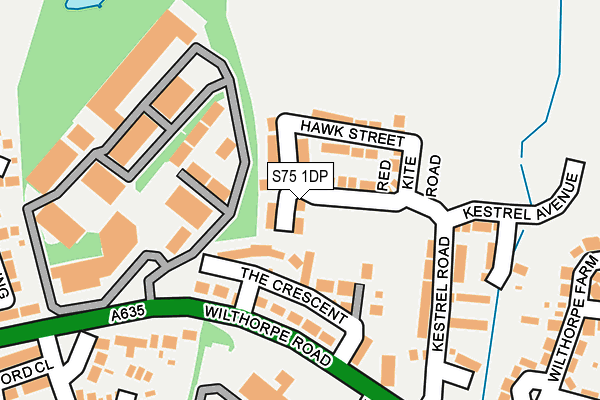
S75 1DP is located in the Darton West electoral ward, within the metropolitan district of Barnsley and the English Parliamentary constituency of Barnsley Central. The Sub Integrated Care Board (ICB) Location is NHS South Yorkshire ICB - 02P and the police force is South Yorkshire. This postcode has been in use since June 2017.


GetTheData
Source: OS OpenMap – Local (Ordnance Survey)
Source: OS VectorMap District (Ordnance Survey)
Licence: Open Government Licence (requires attribution)
| Easting | 433011 |
| Northing | 407927 |
| Latitude | 53.566939 |
| Longitude | -1.503042 |
GetTheData
Source: Open Postcode Geo
Licence: Open Government Licence
| Country | England |
| Postcode District | S75 |
➜ See where S75 is on a map ➜ Where is Redbrook? | |
GetTheData
Source: Land Registry Price Paid Data
Licence: Open Government Licence
| Ward | Darton West |
| Constituency | Barnsley Central |
GetTheData
Source: ONS Postcode Database
Licence: Open Government Licence
| The Crescent (Wilthorpe Road) | Wilthorpe | 141m |
| Innovation Way (Wilthorpe Road) | Wilthorpe | 162m |
| Ripley Grove (Wilthorpe Road) | Wilthorpe | 202m |
| Ripley Grove (Wilthorpe Road) | Wilthorpe | 239m |
| Wilthorpe Road (Rowland Road) | Wilthorpe | 376m |
| Barnsley Station | 2.2km |
| Darton Station | 3km |
| Dodworth Station | 3.2km |
GetTheData
Source: NaPTAN
Licence: Open Government Licence
| Percentage of properties with Next Generation Access | 100.0% |
| Percentage of properties with Superfast Broadband | 100.0% |
| Percentage of properties with Ultrafast Broadband | 100.0% |
| Percentage of properties with Full Fibre Broadband | 0.0% |
Superfast Broadband is between 30Mbps and 300Mbps
Ultrafast Broadband is > 300Mbps
| Median download speed | 69.9Mbps |
| Average download speed | 58.5Mbps |
| Maximum download speed | 100.00Mbps |
| Median upload speed | 1.1Mbps |
| Average upload speed | 2.6Mbps |
| Maximum upload speed | 7.07Mbps |
| Percentage of properties unable to receive 2Mbps | 0.0% |
| Percentage of properties unable to receive 5Mbps | 0.0% |
| Percentage of properties unable to receive 10Mbps | 0.0% |
| Percentage of properties unable to receive 30Mbps | 0.0% |
GetTheData
Source: Ofcom
Licence: Ofcom Terms of Use (requires attribution)
GetTheData
Source: ONS Postcode Database
Licence: Open Government Licence

➜ Get more ratings from the Food Standards Agency
GetTheData
Source: Food Standards Agency
Licence: FSA terms & conditions
| Last Collection | |||
|---|---|---|---|
| Location | Mon-Fri | Sat | Distance |
| Huddersfield Road | 16:00 | 11:30 | 271m |
| Post Office | 17:10 | 11:30 | 638m |
| Gawber Post Office | 17:10 | 11:30 | 707m |
GetTheData
Source: Dracos
Licence: Creative Commons Attribution-ShareAlike
The below table lists the International Territorial Level (ITL) codes (formerly Nomenclature of Territorial Units for Statistics (NUTS) codes) and Local Administrative Units (LAU) codes for S75 1DP:
| ITL 1 Code | Name |
|---|---|
| TLE | Yorkshire and The Humber |
| ITL 2 Code | Name |
| TLE3 | South Yorkshire |
| ITL 3 Code | Name |
| TLE31 | Barnsley, Doncaster and Rotherham |
| LAU 1 Code | Name |
| E08000016 | Barnsley |
GetTheData
Source: ONS Postcode Directory
Licence: Open Government Licence
The below table lists the Census Output Area (OA), Lower Layer Super Output Area (LSOA), and Middle Layer Super Output Area (MSOA) for S75 1DP:
| Code | Name | |
|---|---|---|
| OA | E00037415 | |
| LSOA | E01007381 | Barnsley 012C |
| MSOA | E02001520 | Barnsley 012 |
GetTheData
Source: ONS Postcode Directory
Licence: Open Government Licence
| S75 1JH | The Crescent | 44m |
| S75 1JQ | Wilthorpe Road | 92m |
| S75 1JF | Wilthorpe Road | 196m |
| S75 2RT | Wilthorpe Lane | 253m |
| S75 1JL | Innovation Way | 268m |
| S75 1EW | Wilthorpe Avenue | 276m |
| S75 2RY | Rookdale Close | 284m |
| S75 1JP | Redbrook View | 295m |
| S75 1ES | Wilthorpe Farm Road | 305m |
| S75 1GW | Great Broad Ing | 307m |
GetTheData
Source: Open Postcode Geo; Land Registry Price Paid Data
Licence: Open Government Licence