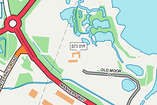
S73 0YF is located in the Darfield electoral ward, within the metropolitan district of Barnsley and the English Parliamentary constituency of Barnsley East. The Sub Integrated Care Board (ICB) Location is NHS South Yorkshire ICB - 02P and the police force is South Yorkshire. This postcode has been in use since January 1980.


GetTheData
Source: OS OpenMap – Local (Ordnance Survey)
Source: OS VectorMap District (Ordnance Survey)
Licence: Open Government Licence (requires attribution)
| Easting | 442226 |
| Northing | 402279 |
| Latitude | 53.515500 |
| Longitude | -1.364672 |
GetTheData
Source: Open Postcode Geo
Licence: Open Government Licence
| Country | England |
| Postcode District | S73 |
➜ See where S73 is on a map | |
GetTheData
Source: Land Registry Price Paid Data
Licence: Open Government Licence
Elevation or altitude of S73 0YF as distance above sea level:
| Metres | Feet | |
|---|---|---|
| Elevation | 20m | 66ft |
Elevation is measured from the approximate centre of the postcode, to the nearest point on an OS contour line from OS Terrain 50, which has contour spacing of ten vertical metres.
➜ How high above sea level am I? Find the elevation of your current position using your device's GPS.
GetTheData
Source: Open Postcode Elevation
Licence: Open Government Licence
| Ward | Darfield |
| Constituency | Barnsley East |
GetTheData
Source: ONS Postcode Database
Licence: Open Government Licence
| Wetlands Centre (Manvers Way) | Old Moor | 266m |
| Wetlands Centre (Manvers Way) | Old Moor | 371m |
| Everill Gate Lane (High Gate) | Broomhill | 548m |
| Everill Gate Lane (Highgate) | Broomhill | 554m |
| Grove Road (Barnsley Road) | West Melton | 592m |
| Wombwell Station | 3.4km |
| Bolton-Upon-Dearne Station | 3.5km |
| Goldthorpe Station | 4km |
GetTheData
Source: NaPTAN
Licence: Open Government Licence
GetTheData
Source: ONS Postcode Database
Licence: Open Government Licence


➜ Get more ratings from the Food Standards Agency
GetTheData
Source: Food Standards Agency
Licence: FSA terms & conditions
| Last Collection | |||
|---|---|---|---|
| Location | Mon-Fri | Sat | Distance |
| 255 Wath Road | 17:00 | 11:15 | 623m |
| West Mount Avenue | 16:00 | 11:15 | 685m |
| Masefield Road | 16:00 | 11:00 | 967m |
GetTheData
Source: Dracos
Licence: Creative Commons Attribution-ShareAlike
The below table lists the International Territorial Level (ITL) codes (formerly Nomenclature of Territorial Units for Statistics (NUTS) codes) and Local Administrative Units (LAU) codes for S73 0YF:
| ITL 1 Code | Name |
|---|---|
| TLE | Yorkshire and The Humber |
| ITL 2 Code | Name |
| TLE3 | South Yorkshire |
| ITL 3 Code | Name |
| TLE31 | Barnsley, Doncaster and Rotherham |
| LAU 1 Code | Name |
| E08000016 | Barnsley |
GetTheData
Source: ONS Postcode Directory
Licence: Open Government Licence
The below table lists the Census Output Area (OA), Lower Layer Super Output Area (LSOA), and Middle Layer Super Output Area (MSOA) for S73 0YF:
| Code | Name | |
|---|---|---|
| OA | E00037786 | |
| LSOA | E01032924 | Barnsley 026F |
| MSOA | E02001534 | Barnsley 026 |
GetTheData
Source: ONS Postcode Directory
Licence: Open Government Licence
| S73 0XY | Pontefract Road | 492m |
| S73 0FH | Highgate | 494m |
| S73 0UP | Bittern Croft | 506m |
| S73 0WD | Kingfisher Mews | 537m |
| S73 0XZ | Moorbridge Crescent | 537m |
| S73 0XX | Pontefract Road | 538m |
| S73 0YG | Pontefract Road | 540m |
| S73 0YA | Moorbridge Crescent | 541m |
| S73 0FD | The Sidings | 552m |
| S63 6DT | Hollowgate Avenue | 561m |
GetTheData
Source: Open Postcode Geo; Land Registry Price Paid Data
Licence: Open Government Licence