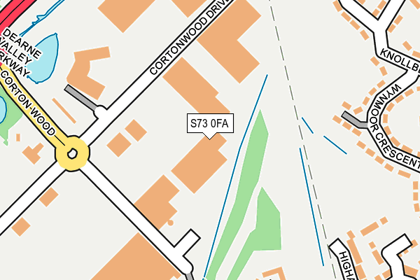
S73 0FA is located in the Hoober electoral ward, within the metropolitan district of Rotherham and the English Parliamentary constituency of Wentworth and Dearne. The Sub Integrated Care Board (ICB) Location is NHS South Yorkshire ICB - 03L and the police force is South Yorkshire. This postcode has been in use since June 2017.


GetTheData
Source: OS OpenMap – Local (Ordnance Survey)
Source: OS VectorMap District (Ordnance Survey)
Licence: Open Government Licence (requires attribution)
| Easting | 440875 |
| Northing | 401526 |
| Latitude | 53.508857 |
| Longitude | -1.385143 |
GetTheData
Source: Open Postcode Geo
Licence: Open Government Licence
| Country | England |
| Postcode District | S73 |
➜ See where S73 is on a map ➜ Where is Brampton? | |
GetTheData
Source: Land Registry Price Paid Data
Licence: Open Government Licence
| Ward | Hoober |
| Constituency | Wentworth And Dearne |
GetTheData
Source: ONS Postcode Database
Licence: Open Government Licence
| Dearne Valley Parkway (Corton Wood) | Cortonwood | 228m |
| Dearne Valley Parkway (Corton Wood) | Cortonwood | 260m |
| Knollbeck Crescent (Knollbeck Lane) | Brampton | 515m |
| Garden Drive (Knollbeck Lane) | Brampton | 521m |
| Cliffe Road (Knollbeck Lane) | Brampton | 539m |
| Wombwell Station | 2.3km |
| Elsecar Station | 3km |
| Bolton-Upon-Dearne Station | 5km |
GetTheData
Source: NaPTAN
Licence: Open Government Licence
| Median download speed | 1.1Mbps |
| Average download speed | 2.2Mbps |
| Maximum download speed | 4.60Mbps |
| Median upload speed | 0.7Mbps |
| Average upload speed | 0.7Mbps |
| Maximum upload speed | 1.09Mbps |
GetTheData
Source: Ofcom
Licence: Ofcom Terms of Use (requires attribution)
GetTheData
Source: ONS Postcode Database
Licence: Open Government Licence


➜ Get more ratings from the Food Standards Agency
GetTheData
Source: Food Standards Agency
Licence: FSA terms & conditions
| Last Collection | |||
|---|---|---|---|
| Location | Mon-Fri | Sat | Distance |
| Cortonwood | 18:45 | 230m | |
| Knollbeck Avenue | 17:00 | 11:15 | 439m |
| Post Office | 17:10 | 11:15 | 527m |
GetTheData
Source: Dracos
Licence: Creative Commons Attribution-ShareAlike
The below table lists the International Territorial Level (ITL) codes (formerly Nomenclature of Territorial Units for Statistics (NUTS) codes) and Local Administrative Units (LAU) codes for S73 0FA:
| ITL 1 Code | Name |
|---|---|
| TLE | Yorkshire and The Humber |
| ITL 2 Code | Name |
| TLE3 | South Yorkshire |
| ITL 3 Code | Name |
| TLE31 | Barnsley, Doncaster and Rotherham |
| LAU 1 Code | Name |
| E08000018 | Rotherham |
GetTheData
Source: ONS Postcode Directory
Licence: Open Government Licence
The below table lists the Census Output Area (OA), Lower Layer Super Output Area (LSOA), and Middle Layer Super Output Area (MSOA) for S73 0FA:
| Code | Name | |
|---|---|---|
| OA | E00038981 | |
| LSOA | E01007694 | Rotherham 001B |
| MSOA | E02001578 | Rotherham 001 |
GetTheData
Source: ONS Postcode Directory
Licence: Open Government Licence
| S73 0UD | Wynmoor Crescent | 240m |
| S73 0TG | Garden Drive | 295m |
| S63 6FB | Collier Court | 297m |
| S63 6GB | Witham Way | 304m |
| S73 0UE | Wynmoor Crescent | 307m |
| S63 6FD | Lakeside Court | 320m |
| S73 0UJ | Wyn Grove | 337m |
| S63 6FY | Higham Road | 347m |
| S63 6FA | Ploughmans Croft | 351m |
| S73 0UL | Knollbeck Avenue | 363m |
GetTheData
Source: Open Postcode Geo; Land Registry Price Paid Data
Licence: Open Government Licence