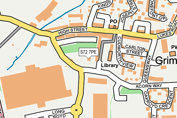
S72 7PE is located in the North East electoral ward, within the metropolitan district of Barnsley and the English Parliamentary constituency of Barnsley East. The Sub Integrated Care Board (ICB) Location is NHS South Yorkshire ICB - 02P and the police force is South Yorkshire. This postcode has been in use since September 2011.


GetTheData
Source: OS OpenMap – Local (Ordnance Survey)
Source: OS VectorMap District (Ordnance Survey)
Licence: Open Government Licence (requires attribution)
| Easting | 440994 |
| Northing | 408842 |
| Latitude | 53.574584 |
| Longitude | -1.382392 |
GetTheData
Source: Open Postcode Geo
Licence: Open Government Licence
| Country | England |
| Postcode District | S72 |
➜ See where S72 is on a map ➜ Where is Grimethorpe? | |
GetTheData
Source: Land Registry Price Paid Data
Licence: Open Government Licence
Elevation or altitude of S72 7PE as distance above sea level:
| Metres | Feet | |
|---|---|---|
| Elevation | 40m | 131ft |
Elevation is measured from the approximate centre of the postcode, to the nearest point on an OS contour line from OS Terrain 50, which has contour spacing of ten vertical metres.
➜ How high above sea level am I? Find the elevation of your current position using your device's GPS.
GetTheData
Source: Open Postcode Elevation
Licence: Open Government Licence
| Ward | North East |
| Constituency | Barnsley East |
GetTheData
Source: ONS Postcode Database
Licence: Open Government Licence
| High Street (Acorn Way) | Grimethorpe | 108m |
| Cudworth View (High Street) | Grimethorpe | 111m |
| North View (Acorn Way) | Grimethorpe | 136m |
| Joseph Street (High Street) | Grimethorpe | 162m |
| Interchange Stand 3 (Queensway) | Grimethorpe | 197m |
| Thurnscoe Station | 5.9km |
| Goldthorpe Station | 6.4km |
GetTheData
Source: NaPTAN
Licence: Open Government Licence
GetTheData
Source: ONS Postcode Database
Licence: Open Government Licence


➜ Get more ratings from the Food Standards Agency
GetTheData
Source: Food Standards Agency
Licence: FSA terms & conditions
| Last Collection | |||
|---|---|---|---|
| Location | Mon-Fri | Sat | Distance |
| Post Office | 16:00 | 11:15 | 133m |
| Post Office | 16:45 | 11:15 | 507m |
| 20a Micharls Estate | 16:00 | 09:00 | 525m |
GetTheData
Source: Dracos
Licence: Creative Commons Attribution-ShareAlike
The below table lists the International Territorial Level (ITL) codes (formerly Nomenclature of Territorial Units for Statistics (NUTS) codes) and Local Administrative Units (LAU) codes for S72 7PE:
| ITL 1 Code | Name |
|---|---|
| TLE | Yorkshire and The Humber |
| ITL 2 Code | Name |
| TLE3 | South Yorkshire |
| ITL 3 Code | Name |
| TLE31 | Barnsley, Doncaster and Rotherham |
| LAU 1 Code | Name |
| E08000016 | Barnsley |
GetTheData
Source: ONS Postcode Directory
Licence: Open Government Licence
The below table lists the Census Output Area (OA), Lower Layer Super Output Area (LSOA), and Middle Layer Super Output Area (MSOA) for S72 7PE:
| Code | Name | |
|---|---|---|
| OA | E00037147 | |
| LSOA | E01007332 | Barnsley 006C |
| MSOA | E02001514 | Barnsley 006 |
GetTheData
Source: ONS Postcode Directory
Licence: Open Government Licence
| S72 7BB | High Street | 83m |
| S72 7LW | Cudworth View | 139m |
| S72 7LP | High Street | 141m |
| S72 7LR | High Street | 148m |
| S72 7BD | High Street | 151m |
| S72 7BL | North View | 157m |
| S72 7LJ | Queensway | 186m |
| S72 7LS | High Street | 190m |
| S72 7FR | Cloister Way | 219m |
| S72 7DZ | Joseph Street | 221m |
GetTheData
Source: Open Postcode Geo; Land Registry Price Paid Data
Licence: Open Government Licence