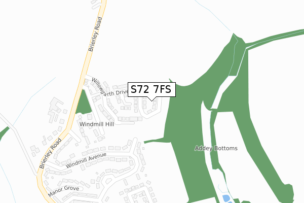
S72 7FS is located in the North East electoral ward, within the metropolitan district of Barnsley and the English Parliamentary constituency of Barnsley East. The Sub Integrated Care Board (ICB) Location is NHS South Yorkshire ICB - 02P and the police force is South Yorkshire. This postcode has been in use since April 2018.


GetTheData
Source: OS Open Zoomstack (Ordnance Survey)
Licence: Open Government Licence (requires attribution)
Attribution: Contains OS data © Crown copyright and database right 2024
Source: Open Postcode Geo
Licence: Open Government Licence (requires attribution)
Attribution: Contains OS data © Crown copyright and database right 2024; Contains Royal Mail data © Royal Mail copyright and database right 2024; Source: Office for National Statistics licensed under the Open Government Licence v.3.0
| Easting | 441292 |
| Northing | 410160 |
| Latitude | 53.586423 |
| Longitude | -1.377721 |
GetTheData
Source: Open Postcode Geo
Licence: Open Government Licence
| Country | England |
| Postcode District | S72 |
➜ See where S72 is on a map ➜ Where is Grimethorpe? | |
GetTheData
Source: Land Registry Price Paid Data
Licence: Open Government Licence
| Ward | North East |
| Constituency | Barnsley East |
GetTheData
Source: ONS Postcode Database
Licence: Open Government Licence
34, GARTH VIEW, GRIMETHORPE, BARNSLEY, S72 7FS 2021 5 NOV £269,995 |
30, GARTH VIEW, GRIMETHORPE, BARNSLEY, S72 7FS 2021 2 JUL £275,000 |
32, GARTH VIEW, GRIMETHORPE, BARNSLEY, S72 7FS 2021 28 MAY £265,000 |
26, GARTH VIEW, GRIMETHORPE, BARNSLEY, S72 7FS 2021 30 APR £265,000 |
16, GARTH VIEW, GRIMETHORPE, BARNSLEY, S72 7FS 2021 27 APR £255,000 |
8, GARTH VIEW, GRIMETHORPE, BARNSLEY, S72 7FS 2021 24 APR £175,995 |
28, GARTH VIEW, GRIMETHORPE, BARNSLEY, S72 7FS 2021 1 APR £264,995 |
20, GARTH VIEW, GRIMETHORPE, BARNSLEY, S72 7FS 2021 19 MAR £259,000 |
18, GARTH VIEW, GRIMETHORPE, BARNSLEY, S72 7FS 2021 5 MAR £259,000 |
25, GARTH VIEW, GRIMETHORPE, BARNSLEY, S72 7FS 2021 26 FEB £259,995 |
GetTheData
Source: HM Land Registry Price Paid Data
Licence: Contains HM Land Registry data © Crown copyright and database right 2024. This data is licensed under the Open Government Licence v3.0.
| Adj. Willowgarth School (Brierley Road) | Grimethorpe | 248m |
| Willowgarth School (Brierley Road) | Grimethorpe | 271m |
| Sandhill Grove (Brierley Road) | Brierley | 287m |
| Manor Crescent (Windmill Avenue) | Grimethorpe | 292m |
| Windmill Avenue (Brierley Road) | Grimethorpe | 391m |
| Moorthorpe Station | 4.9km |
| Thurnscoe Station | 6.5km |
GetTheData
Source: NaPTAN
Licence: Open Government Licence
GetTheData
Source: ONS Postcode Database
Licence: Open Government Licence


➜ Get more ratings from the Food Standards Agency
GetTheData
Source: Food Standards Agency
Licence: FSA terms & conditions
| Last Collection | |||
|---|---|---|---|
| Location | Mon-Fri | Sat | Distance |
| 20a Micharls Estate | 16:00 | 09:00 | 844m |
| High Street | 16:15 | 12:00 | 975m |
| Post Office | 16:15 | 11:00 | 1,147m |
GetTheData
Source: Dracos
Licence: Creative Commons Attribution-ShareAlike
The below table lists the International Territorial Level (ITL) codes (formerly Nomenclature of Territorial Units for Statistics (NUTS) codes) and Local Administrative Units (LAU) codes for S72 7FS:
| ITL 1 Code | Name |
|---|---|
| TLE | Yorkshire and The Humber |
| ITL 2 Code | Name |
| TLE3 | South Yorkshire |
| ITL 3 Code | Name |
| TLE31 | Barnsley, Doncaster and Rotherham |
| LAU 1 Code | Name |
| E08000016 | Barnsley |
GetTheData
Source: ONS Postcode Directory
Licence: Open Government Licence
The below table lists the Census Output Area (OA), Lower Layer Super Output Area (LSOA), and Middle Layer Super Output Area (MSOA) for S72 7FS:
| Code | Name | |
|---|---|---|
| OA | E00037159 | |
| LSOA | E01007328 | Barnsley 006A |
| MSOA | E02001514 | Barnsley 006 |
GetTheData
Source: ONS Postcode Directory
Licence: Open Government Licence
| S72 7AL | Windmill Avenue | 151m |
| S72 7AH | Windmill Avenue | 247m |
| S72 7AT | Sandhill Grove | 257m |
| S72 7AN | Windmill Avenue | 294m |
| S72 7AW | Brierley Road | 307m |
| S72 7HE | Mount Pleasant | 336m |
| S72 9JJ | Hillside | 405m |
| S72 7AG | Manor Crescent | 409m |
| S72 7AF | Manor Crescent | 422m |
| S72 7HB | Mount Road | 440m |
GetTheData
Source: Open Postcode Geo; Land Registry Price Paid Data
Licence: Open Government Licence