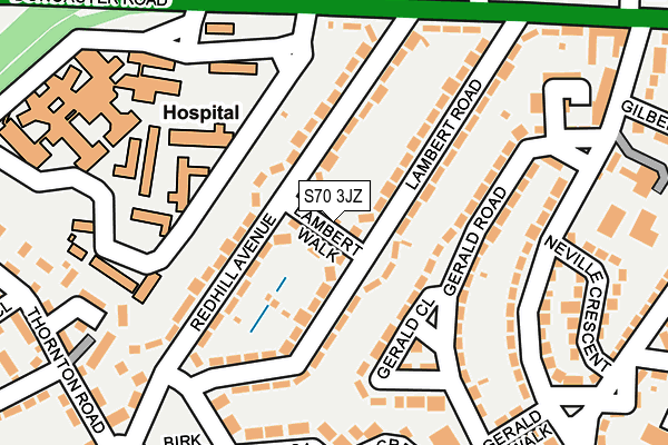
S70 3JZ is located in the Stairfoot electoral ward, within the metropolitan district of Barnsley and the English Parliamentary constituency of Barnsley East. The Sub Integrated Care Board (ICB) Location is NHS South Yorkshire ICB - 02P and the police force is South Yorkshire. This postcode has been in use since July 2017.


GetTheData
Source: OS OpenMap – Local (Ordnance Survey)
Source: OS VectorMap District (Ordnance Survey)
Licence: Open Government Licence (requires attribution)
| Easting | 435809 |
| Northing | 405023 |
| Latitude | 53.540656 |
| Longitude | -1.461128 |
GetTheData
Source: Open Postcode Geo
Licence: Open Government Licence
| Country | England |
| Postcode District | S70 |
➜ See where S70 is on a map ➜ Where is Barnsley? | |
GetTheData
Source: Land Registry Price Paid Data
Licence: Open Government Licence
| Ward | Stairfoot |
| Constituency | Barnsley East |
GetTheData
Source: ONS Postcode Database
Licence: Open Government Licence
| Cedar Crescent (Cypress Road) | Kendray | 104m |
| Swanee Road (Cypress Road) | Kendray | 109m |
| Swanee Road (Cypress Road) | Kendray | 135m |
| Farm Road (Cypress Road) | Kendray | 207m |
| Yews Place (Cypress Road) | Kendray | 269m |
| Barnsley Station | 1.9km |
| Wombwell Station | 3.9km |
| Dodworth Station | 4.7km |
GetTheData
Source: NaPTAN
Licence: Open Government Licence
| Percentage of properties with Next Generation Access | 100.0% |
| Percentage of properties with Superfast Broadband | 100.0% |
| Percentage of properties with Ultrafast Broadband | 0.0% |
| Percentage of properties with Full Fibre Broadband | 0.0% |
Superfast Broadband is between 30Mbps and 300Mbps
Ultrafast Broadband is > 300Mbps
| Percentage of properties unable to receive 2Mbps | 0.0% |
| Percentage of properties unable to receive 5Mbps | 0.0% |
| Percentage of properties unable to receive 10Mbps | 0.0% |
| Percentage of properties unable to receive 30Mbps | 0.0% |
GetTheData
Source: Ofcom
Licence: Ofcom Terms of Use (requires attribution)
GetTheData
Source: ONS Postcode Database
Licence: Open Government Licence


➜ Get more ratings from the Food Standards Agency
GetTheData
Source: Food Standards Agency
Licence: FSA terms & conditions
| Last Collection | |||
|---|---|---|---|
| Location | Mon-Fri | Sat | Distance |
| 190 Farm Road | 16:45 | 11:45 | 188m |
| 148 Upper Sheffield Road | 16:45 | 11:45 | 418m |
| 15 Bank End Road | 17:10 | 11:00 | 647m |
GetTheData
Source: Dracos
Licence: Creative Commons Attribution-ShareAlike
The below table lists the International Territorial Level (ITL) codes (formerly Nomenclature of Territorial Units for Statistics (NUTS) codes) and Local Administrative Units (LAU) codes for S70 3JZ:
| ITL 1 Code | Name |
|---|---|
| TLE | Yorkshire and The Humber |
| ITL 2 Code | Name |
| TLE3 | South Yorkshire |
| ITL 3 Code | Name |
| TLE31 | Barnsley, Doncaster and Rotherham |
| LAU 1 Code | Name |
| E08000016 | Barnsley |
GetTheData
Source: ONS Postcode Directory
Licence: Open Government Licence
The below table lists the Census Output Area (OA), Lower Layer Super Output Area (LSOA), and Middle Layer Super Output Area (MSOA) for S70 3JZ:
| Code | Name | |
|---|---|---|
| OA | E00037571 | |
| LSOA | E01007416 | Barnsley 018D |
| MSOA | E02001526 | Barnsley 018 |
GetTheData
Source: ONS Postcode Directory
Licence: Open Government Licence
| S70 3LR | Yews Lane | 37m |
| S70 3LX | Cypress Road | 119m |
| S70 3LP | Cedar Crescent | 130m |
| S70 3LZ | Cypress Road | 132m |
| S70 3LW | Yews Lane | 163m |
| S70 3DE | Swanee Road | 170m |
| S70 3LN | Yews Lane | 205m |
| S70 3DG | Larch Place | 207m |
| S70 3NB | Cypress Road | 237m |
| S70 3DW | Farm Road | 257m |
GetTheData
Source: Open Postcode Geo; Land Registry Price Paid Data
Licence: Open Government Licence