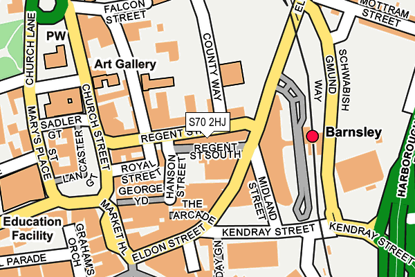
S70 2HJ is located in the Central electoral ward, within the metropolitan district of Barnsley and the English Parliamentary constituency of Barnsley Central. The Sub Integrated Care Board (ICB) Location is NHS South Yorkshire ICB - 02P and the police force is South Yorkshire. This postcode has been in use since January 1980.


GetTheData
Source: OS OpenMap – Local (Ordnance Survey)
Source: OS VectorMap District (Ordnance Survey)
Licence: Open Government Licence (requires attribution)
| Easting | 434578 |
| Northing | 406539 |
| Latitude | 53.554345 |
| Longitude | -1.479534 |
GetTheData
Source: Open Postcode Geo
Licence: Open Government Licence
| Country | England |
| Postcode District | S70 |
➜ See where S70 is on a map ➜ Where is Barnsley? | |
GetTheData
Source: Land Registry Price Paid Data
Licence: Open Government Licence
Elevation or altitude of S70 2HJ as distance above sea level:
| Metres | Feet | |
|---|---|---|
| Elevation | 100m | 328ft |
Elevation is measured from the approximate centre of the postcode, to the nearest point on an OS contour line from OS Terrain 50, which has contour spacing of ten vertical metres.
➜ How high above sea level am I? Find the elevation of your current position using your device's GPS.
GetTheData
Source: Open Postcode Elevation
Licence: Open Government Licence
| Ward | Central |
| Constituency | Barnsley Central |
GetTheData
Source: ONS Postcode Database
Licence: Open Government Licence
| County Way (Regent Street) | Barnsley Town Centre | 46m |
| Barnsley Interchange (Eldon Street) | Barnsley Town Centre | 109m |
| Schwabisch Gmund Way (Schwabish Gmund Way) | Barnsley Town Centre | 172m |
| Market Hill (Eldon Street) | Barnsley Town Centre | 195m |
| Shambles Street (St Marys Place) | Barnsley Town Centre | 243m |
| Barnsley Station | 0.2km |
| Dodworth Station | 3.6km |
| Darton Station | 5.1km |
GetTheData
Source: NaPTAN
Licence: Open Government Licence
GetTheData
Source: ONS Postcode Database
Licence: Open Government Licence


➜ Get more ratings from the Food Standards Agency
GetTheData
Source: Food Standards Agency
Licence: FSA terms & conditions
| Last Collection | |||
|---|---|---|---|
| Location | Mon-Fri | Sat | Distance |
| Church Street | 18:45 | 11:00 | 152m |
| Barnsley Delivery Office | 19:30 | 12:45 | 322m |
| Technical College | 18:45 | 11:30 | 335m |
GetTheData
Source: Dracos
Licence: Creative Commons Attribution-ShareAlike
The below table lists the International Territorial Level (ITL) codes (formerly Nomenclature of Territorial Units for Statistics (NUTS) codes) and Local Administrative Units (LAU) codes for S70 2HJ:
| ITL 1 Code | Name |
|---|---|
| TLE | Yorkshire and The Humber |
| ITL 2 Code | Name |
| TLE3 | South Yorkshire |
| ITL 3 Code | Name |
| TLE31 | Barnsley, Doncaster and Rotherham |
| LAU 1 Code | Name |
| E08000016 | Barnsley |
GetTheData
Source: ONS Postcode Directory
Licence: Open Government Licence
The below table lists the Census Output Area (OA), Lower Layer Super Output Area (LSOA), and Middle Layer Super Output Area (MSOA) for S70 2HJ:
| Code | Name | |
|---|---|---|
| OA | E00037180 | |
| LSOA | E01007340 | Barnsley 013B |
| MSOA | E02001521 | Barnsley 013 |
GetTheData
Source: ONS Postcode Directory
Licence: Open Government Licence
| S70 2EG | Regent Street | 43m |
| S70 2JJ | Eldon Street | 94m |
| S70 2ED | Royal Street | 110m |
| S70 2EJ | Regent Street | 115m |
| S70 2QP | The Arcade | 132m |
| S70 2EX | Eastgate | 139m |
| S70 2AL | Church Street | 168m |
| S70 2QE | Market Hill | 169m |
| S70 2JR | Eldon Street | 173m |
| S70 1SH | May Day Green | 202m |
GetTheData
Source: Open Postcode Geo; Land Registry Price Paid Data
Licence: Open Government Licence