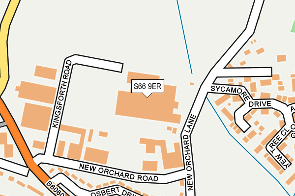
S66 9ER is located in the Thurcroft & Wickersley South electoral ward, within the metropolitan district of Rotherham and the English Parliamentary constituency of Rother Valley. The Sub Integrated Care Board (ICB) Location is NHS South Yorkshire ICB - 03L and the police force is South Yorkshire. This postcode has been in use since January 1980.


GetTheData
Source: OS OpenMap – Local (Ordnance Survey)
Source: OS VectorMap District (Ordnance Survey)
Licence: Open Government Licence (requires attribution)
| Easting | 449397 |
| Northing | 389457 |
| Latitude | 53.399636 |
| Longitude | -1.258547 |
GetTheData
Source: Open Postcode Geo
Licence: Open Government Licence
| Country | England |
| Postcode District | S66 |
➜ See where S66 is on a map ➜ Where is Thurcroft? | |
GetTheData
Source: Land Registry Price Paid Data
Licence: Open Government Licence
Elevation or altitude of S66 9ER as distance above sea level:
| Metres | Feet | |
|---|---|---|
| Elevation | 120m | 394ft |
Elevation is measured from the approximate centre of the postcode, to the nearest point on an OS contour line from OS Terrain 50, which has contour spacing of ten vertical metres.
➜ How high above sea level am I? Find the elevation of your current position using your device's GPS.
GetTheData
Source: Open Postcode Elevation
Licence: Open Government Licence
| Ward | Thurcroft & Wickersley South |
| Constituency | Rother Valley |
GetTheData
Source: ONS Postcode Database
Licence: Open Government Licence
| New Orchard Road (Woodhouse Green) | Thurcroft | 266m |
| New Orchard Road (Woodhouse Green) | Thurcroft | 279m |
| New Orchard Lane (Sandy Lane) | Thurcroft | 382m |
| Woodhouse Green (Brampton Road) | Thurcroft | 433m |
| Katherine Road (Brampton Road) | Thurcroft | 439m |
GetTheData
Source: NaPTAN
Licence: Open Government Licence
GetTheData
Source: ONS Postcode Database
Licence: Open Government Licence


➜ Get more ratings from the Food Standards Agency
GetTheData
Source: Food Standards Agency
Licence: FSA terms & conditions
| Last Collection | |||
|---|---|---|---|
| Location | Mon-Fri | Sat | Distance |
| Thurcroft Post Office | 17:00 | 12:00 | 312m |
| Katherine Road | 16:00 | 10:30 | 488m |
| Aymer Drive | 16:45 | 11:45 | 881m |
GetTheData
Source: Dracos
Licence: Creative Commons Attribution-ShareAlike
The below table lists the International Territorial Level (ITL) codes (formerly Nomenclature of Territorial Units for Statistics (NUTS) codes) and Local Administrative Units (LAU) codes for S66 9ER:
| ITL 1 Code | Name |
|---|---|
| TLE | Yorkshire and The Humber |
| ITL 2 Code | Name |
| TLE3 | South Yorkshire |
| ITL 3 Code | Name |
| TLE31 | Barnsley, Doncaster and Rotherham |
| LAU 1 Code | Name |
| E08000018 | Rotherham |
GetTheData
Source: ONS Postcode Directory
Licence: Open Government Licence
The below table lists the Census Output Area (OA), Lower Layer Super Output Area (LSOA), and Middle Layer Super Output Area (MSOA) for S66 9ER:
| Code | Name | |
|---|---|---|
| OA | E00039558 | |
| LSOA | E01007810 | Rotherham 026C |
| MSOA | E02001603 | Rotherham 026 |
GetTheData
Source: ONS Postcode Directory
Licence: Open Government Licence
| S66 9HY | Thurcroft Industrial Estate | 163m |
| S66 9AF | Osbert Drive | 186m |
| S66 9AD | New Orchard Lane | 189m |
| S66 9EU | Pasture Croft | 200m |
| S66 9AW | Colliery Villas | 219m |
| S66 9AG | Osbert Drive | 225m |
| S66 9EP | Sycamore Drive | 232m |
| S66 9AE | New Orchard Lane | 277m |
| S66 9AQ | Woodhouse Green | 285m |
| S66 9EY | Yew Tree Close | 286m |
GetTheData
Source: Open Postcode Geo; Land Registry Price Paid Data
Licence: Open Government Licence