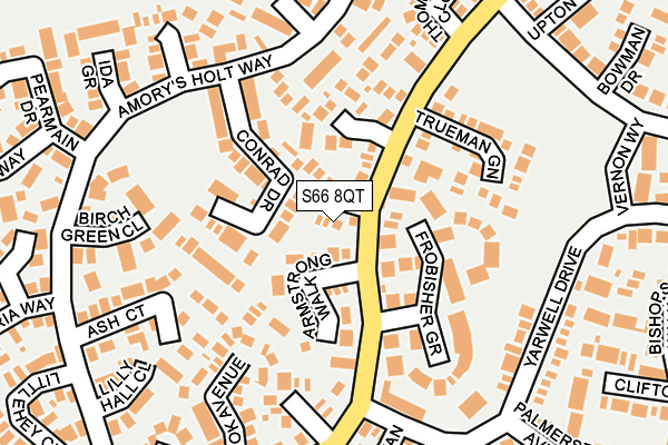
S66 8QT lies on Aldrin Way in Maltby, Rotherham. S66 8QT is located in the Hellaby & Maltby West electoral ward, within the metropolitan district of Rotherham and the English Parliamentary constituency of Rother Valley. The Sub Integrated Care Board (ICB) Location is NHS South Yorkshire ICB - 03L and the police force is South Yorkshire. This postcode has been in use since April 1985.


GetTheData
Source: OS OpenMap – Local (Ordnance Survey)
Source: OS VectorMap District (Ordnance Survey)
Licence: Open Government Licence (requires attribution)
| Easting | 452113 |
| Northing | 392848 |
| Latitude | 53.429853 |
| Longitude | -1.217143 |
GetTheData
Source: Open Postcode Geo
Licence: Open Government Licence
| Street | Aldrin Way |
| Locality | Maltby |
| Town/City | Rotherham |
| Country | England |
| Postcode District | S66 |
➜ See where S66 is on a map ➜ Where is Maltby? | |
GetTheData
Source: Land Registry Price Paid Data
Licence: Open Government Licence
Elevation or altitude of S66 8QT as distance above sea level:
| Metres | Feet | |
|---|---|---|
| Elevation | 130m | 427ft |
Elevation is measured from the approximate centre of the postcode, to the nearest point on an OS contour line from OS Terrain 50, which has contour spacing of ten vertical metres.
➜ How high above sea level am I? Find the elevation of your current position using your device's GPS.
GetTheData
Source: Open Postcode Elevation
Licence: Open Government Licence
| Ward | Hellaby & Maltby West |
| Constituency | Rother Valley |
GetTheData
Source: ONS Postcode Database
Licence: Open Government Licence
2010 14 MAY £108,000 |
2007 30 MAR £125,000 |
2006 27 OCT £137,000 |
2002 25 JAN £63,750 |
1999 5 NOV £49,950 |
1999 30 SEP £49,500 |
GetTheData
Source: HM Land Registry Price Paid Data
Licence: Contains HM Land Registry data © Crown copyright and database right 2025. This data is licensed under the Open Government Licence v3.0.
| Frobisher Grove (Dale Hill Road) | Maltby | 64m |
| Yarwell Drive (Dale Hill Road) | Maltby | 138m |
| Trueman Green (Dale Hill Road) | Maltby | 144m |
| Thompson Close (Dale Hill Road) | Maltby | 225m |
| Bonington Rise (Dale Hill Road) | Maltby | 258m |
GetTheData
Source: NaPTAN
Licence: Open Government Licence
| Percentage of properties with Next Generation Access | 100.0% |
| Percentage of properties with Superfast Broadband | 100.0% |
| Percentage of properties with Ultrafast Broadband | 0.0% |
| Percentage of properties with Full Fibre Broadband | 0.0% |
Superfast Broadband is between 30Mbps and 300Mbps
Ultrafast Broadband is > 300Mbps
| Median download speed | 27.4Mbps |
| Average download speed | 24.8Mbps |
| Maximum download speed | 46.19Mbps |
| Median upload speed | 6.0Mbps |
| Average upload speed | 4.3Mbps |
| Maximum upload speed | 7.36Mbps |
| Percentage of properties unable to receive 2Mbps | 0.0% |
| Percentage of properties unable to receive 5Mbps | 0.0% |
| Percentage of properties unable to receive 10Mbps | 0.0% |
| Percentage of properties unable to receive 30Mbps | 0.0% |
GetTheData
Source: Ofcom
Licence: Ofcom Terms of Use (requires attribution)
GetTheData
Source: ONS Postcode Database
Licence: Open Government Licence


➜ Get more ratings from the Food Standards Agency
GetTheData
Source: Food Standards Agency
Licence: FSA terms & conditions
| Last Collection | |||
|---|---|---|---|
| Location | Mon-Fri | Sat | Distance |
| Yarwell Drive | 16:30 | 11:00 | 159m |
| Birch Green Close | 16:30 | 11:00 | 210m |
| 40 Dale Hill Road | 16:30 | 11:00 | 501m |
GetTheData
Source: Dracos
Licence: Creative Commons Attribution-ShareAlike
The below table lists the International Territorial Level (ITL) codes (formerly Nomenclature of Territorial Units for Statistics (NUTS) codes) and Local Administrative Units (LAU) codes for S66 8QT:
| ITL 1 Code | Name |
|---|---|
| TLE | Yorkshire and The Humber |
| ITL 2 Code | Name |
| TLE3 | South Yorkshire |
| ITL 3 Code | Name |
| TLE31 | Barnsley, Doncaster and Rotherham |
| LAU 1 Code | Name |
| E08000018 | Rotherham |
GetTheData
Source: ONS Postcode Directory
Licence: Open Government Licence
The below table lists the Census Output Area (OA), Lower Layer Super Output Area (LSOA), and Middle Layer Super Output Area (MSOA) for S66 8QT:
| Code | Name | |
|---|---|---|
| OA | E00039312 | |
| LSOA | E01007756 | Rotherham 018D |
| MSOA | E02001595 | Rotherham 018 |
GetTheData
Source: ONS Postcode Directory
Licence: Open Government Licence
| S66 8QQ | Armstrong Walk | 82m |
| S66 8RS | Conrad Drive | 83m |
| S66 8QW | Crossley Close | 99m |
| S66 8QU | Frobisher Grove | 119m |
| S66 8QR | Trueman Green | 143m |
| S66 8QH | Fretwell Close | 159m |
| S66 8QS | Magellan Road | 182m |
| S66 8QZ | Cook Avenue | 183m |
| S66 8RQ | Ash Court | 187m |
| S66 8RP | Birch Green Close | 207m |
GetTheData
Source: Open Postcode Geo; Land Registry Price Paid Data
Licence: Open Government Licence