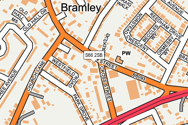
S66 2SB is located in the Wickersley North electoral ward, within the metropolitan district of Rotherham and the English Parliamentary constituency of Wentworth and Dearne. The Sub Integrated Care Board (ICB) Location is NHS South Yorkshire ICB - 03L and the police force is South Yorkshire. This postcode has been in use since June 1997.


GetTheData
Source: OS OpenMap – Local (Ordnance Survey)
Source: OS VectorMap District (Ordnance Survey)
Licence: Open Government Licence (requires attribution)
| Easting | 448931 |
| Northing | 392299 |
| Latitude | 53.425223 |
| Longitude | -1.265114 |
GetTheData
Source: Open Postcode Geo
Licence: Open Government Licence
| Country | England |
| Postcode District | S66 |
➜ See where S66 is on a map ➜ Where is Bramley? | |
GetTheData
Source: Land Registry Price Paid Data
Licence: Open Government Licence
Elevation or altitude of S66 2SB as distance above sea level:
| Metres | Feet | |
|---|---|---|
| Elevation | 130m | 427ft |
Elevation is measured from the approximate centre of the postcode, to the nearest point on an OS contour line from OS Terrain 50, which has contour spacing of ten vertical metres.
➜ How high above sea level am I? Find the elevation of your current position using your device's GPS.
GetTheData
Source: Open Postcode Elevation
Licence: Open Government Licence
| Ward | Wickersley North |
| Constituency | Wentworth And Dearne |
GetTheData
Source: ONS Postcode Database
Licence: Open Government Licence
| Howard Road (Main Street) | Bramley | 73m |
| Westfield Road (Church Lane) | Bramley | 138m |
| Bawtry Road (Cross Street) | Bramley | 143m |
| Cross Street (Bawtry Road) | Bramley | 188m |
| Brook Lane (Main Street) | Bramley | 250m |
GetTheData
Source: NaPTAN
Licence: Open Government Licence
GetTheData
Source: ONS Postcode Database
Licence: Open Government Licence


➜ Get more ratings from the Food Standards Agency
GetTheData
Source: Food Standards Agency
Licence: FSA terms & conditions
| Last Collection | |||
|---|---|---|---|
| Location | Mon-Fri | Sat | Distance |
| Bramley Post Office | 16:00 | 11:30 | 173m |
| Coltishall Avenue | 16:00 | 11:45 | 305m |
| 14 Laurel Avenue | 16:15 | 11:30 | 364m |
GetTheData
Source: Dracos
Licence: Creative Commons Attribution-ShareAlike
The below table lists the International Territorial Level (ITL) codes (formerly Nomenclature of Territorial Units for Statistics (NUTS) codes) and Local Administrative Units (LAU) codes for S66 2SB:
| ITL 1 Code | Name |
|---|---|
| TLE | Yorkshire and The Humber |
| ITL 2 Code | Name |
| TLE3 | South Yorkshire |
| ITL 3 Code | Name |
| TLE31 | Barnsley, Doncaster and Rotherham |
| LAU 1 Code | Name |
| E08000018 | Rotherham |
GetTheData
Source: ONS Postcode Directory
Licence: Open Government Licence
The below table lists the Census Output Area (OA), Lower Layer Super Output Area (LSOA), and Middle Layer Super Output Area (MSOA) for S66 2SB:
| Code | Name | |
|---|---|---|
| OA | E00038927 | |
| LSOA | E01007684 | Rotherham 022A |
| MSOA | E02001599 | Rotherham 022 |
GetTheData
Source: ONS Postcode Directory
Licence: Open Government Licence
| S66 2SE | Main Street | 55m |
| S66 2YG | Balk Lane | 58m |
| S66 2SA | Cross Street | 93m |
| S66 2RX | Westfield Road | 98m |
| S66 2US | Church Lane Mews | 119m |
| S66 2RY | Park Grove | 129m |
| S66 2RZ | Park Grove | 134m |
| S66 2SH | Norstead Crescent | 150m |
| S66 2SQ | Main Street | 155m |
| S66 2SX | Howard Road | 174m |
GetTheData
Source: Open Postcode Geo; Land Registry Price Paid Data
Licence: Open Government Licence