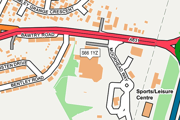
S66 1YZ is located in the Bramley & Ravenfield electoral ward, within the metropolitan district of Rotherham and the English Parliamentary constituency of Rother Valley. The Sub Integrated Care Board (ICB) Location is NHS South Yorkshire ICB - 03L and the police force is South Yorkshire. This postcode has been in use since June 1997.


GetTheData
Source: OS OpenMap – Local (Ordnance Survey)
Source: OS VectorMap District (Ordnance Survey)
Licence: Open Government Licence (requires attribution)
| Easting | 449470 |
| Northing | 392107 |
| Latitude | 53.423447 |
| Longitude | -1.257034 |
GetTheData
Source: Open Postcode Geo
Licence: Open Government Licence
| Country | England |
| Postcode District | S66 |
➜ See where S66 is on a map ➜ Where is Bramley? | |
GetTheData
Source: Land Registry Price Paid Data
Licence: Open Government Licence
Elevation or altitude of S66 1YZ as distance above sea level:
| Metres | Feet | |
|---|---|---|
| Elevation | 120m | 394ft |
Elevation is measured from the approximate centre of the postcode, to the nearest point on an OS contour line from OS Terrain 50, which has contour spacing of ten vertical metres.
➜ How high above sea level am I? Find the elevation of your current position using your device's GPS.
GetTheData
Source: Open Postcode Elevation
Licence: Open Government Licence
| Ward | Bramley & Ravenfield |
| Constituency | Rother Valley |
GetTheData
Source: ONS Postcode Database
Licence: Open Government Licence
| Bentley Road (Bawtry Road) | Bramley | 111m |
| Bentley Road (Bawtry Road) | Bramley | 132m |
| Bramley Grange Crescent | Bramley | 221m |
| Cross Street (Bawtry Road) | Bramley | 427m |
| Crosby Avenue (Flash Lane) | Bramley | 446m |
GetTheData
Source: NaPTAN
Licence: Open Government Licence
GetTheData
Source: ONS Postcode Database
Licence: Open Government Licence


➜ Get more ratings from the Food Standards Agency
GetTheData
Source: Food Standards Agency
Licence: FSA terms & conditions
| Last Collection | |||
|---|---|---|---|
| Location | Mon-Fri | Sat | Distance |
| 184 Bawtry Road | 16:00 | 11:30 | 118m |
| Bramley Post Office | 16:00 | 11:30 | 498m |
| 46 Flash Lane | 16:00 | 11:00 | 532m |
GetTheData
Source: Dracos
Licence: Creative Commons Attribution-ShareAlike
The below table lists the International Territorial Level (ITL) codes (formerly Nomenclature of Territorial Units for Statistics (NUTS) codes) and Local Administrative Units (LAU) codes for S66 1YZ:
| ITL 1 Code | Name |
|---|---|
| TLE | Yorkshire and The Humber |
| ITL 2 Code | Name |
| TLE3 | South Yorkshire |
| ITL 3 Code | Name |
| TLE31 | Barnsley, Doncaster and Rotherham |
| LAU 1 Code | Name |
| E08000018 | Rotherham |
GetTheData
Source: ONS Postcode Directory
Licence: Open Government Licence
The below table lists the Census Output Area (OA), Lower Layer Super Output Area (LSOA), and Middle Layer Super Output Area (MSOA) for S66 1YZ:
| Code | Name | |
|---|---|---|
| OA | E00038933 | |
| LSOA | E01007684 | Rotherham 022A |
| MSOA | E02001599 | Rotherham 022 |
GetTheData
Source: ONS Postcode Directory
Licence: Open Government Licence
| S66 1UJ | Bentley Road | 92m |
| S66 2TR | Bawtry Road | 94m |
| S66 2TP | Bawtry Road | 140m |
| S66 2TS | Bawtry Road | 185m |
| S66 2UX | Bramley Grange Crescent | 208m |
| S66 2XR | Badsworth Place | 217m |
| S66 1YY | Moorhead Way | 252m |
| S66 2XQ | Badsworth Close | 274m |
| S66 2UF | Austen Drive | 286m |
| S66 1UH | Bentley Road | 296m |
GetTheData
Source: Open Postcode Geo; Land Registry Price Paid Data
Licence: Open Government Licence