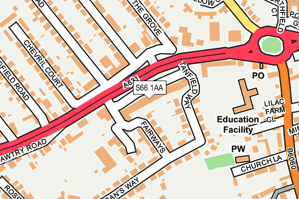
S66 1AA lies on Bawtry Road in Wickersley, Rotherham. S66 1AA is located in the Thurcroft & Wickersley South electoral ward, within the metropolitan district of Rotherham and the English Parliamentary constituency of Rother Valley. The Sub Integrated Care Board (ICB) Location is NHS South Yorkshire ICB - 03L and the police force is South Yorkshire. This postcode has been in use since June 1997.


GetTheData
Source: OS OpenMap – Local (Ordnance Survey)
Source: OS VectorMap District (Ordnance Survey)
Licence: Open Government Licence (requires attribution)
| Easting | 447648 |
| Northing | 391786 |
| Latitude | 53.420729 |
| Longitude | -1.284498 |
GetTheData
Source: Open Postcode Geo
Licence: Open Government Licence
| Street | Bawtry Road |
| Locality | Wickersley |
| Town/City | Rotherham |
| Country | England |
| Postcode District | S66 |
➜ See where S66 is on a map ➜ Where is Wickersley? | |
GetTheData
Source: Land Registry Price Paid Data
Licence: Open Government Licence
Elevation or altitude of S66 1AA as distance above sea level:
| Metres | Feet | |
|---|---|---|
| Elevation | 140m | 459ft |
Elevation is measured from the approximate centre of the postcode, to the nearest point on an OS contour line from OS Terrain 50, which has contour spacing of ten vertical metres.
➜ How high above sea level am I? Find the elevation of your current position using your device's GPS.
GetTheData
Source: Open Postcode Elevation
Licence: Open Government Licence
| Ward | Thurcroft & Wickersley South |
| Constituency | Rother Valley |
GetTheData
Source: ONS Postcode Database
Licence: Open Government Licence
| Tanfield Way (Bawtry Road) | Wickersley | 40m |
| The Grove (Bawtry Road) | Wickersley | 126m |
| Springfield Road (Bawtry Road) | Listerdale | 189m |
| Springfield Road (Bawtry Road) | Listerdale | 250m |
| Moss Close (Morthen Road) | Wickersley | 281m |
GetTheData
Source: NaPTAN
Licence: Open Government Licence
| Median download speed | 24.2Mbps |
| Average download speed | 35.0Mbps |
| Maximum download speed | 80.00Mbps |
| Median upload speed | 1.3Mbps |
| Average upload speed | 6.2Mbps |
| Maximum upload speed | 20.00Mbps |
GetTheData
Source: Ofcom
Licence: Ofcom Terms of Use (requires attribution)
Estimated total energy consumption in S66 1AA by fuel type, 2015.
| Consumption (kWh) | 118,003 |
|---|---|
| Meter count | 7 |
| Mean (kWh/meter) | 16,858 |
| Median (kWh/meter) | 9,184 |
GetTheData
Source: Postcode level gas estimates: 2015 (experimental)
Source: Postcode level electricity estimates: 2015 (experimental)
Licence: Open Government Licence
GetTheData
Source: ONS Postcode Database
Licence: Open Government Licence


➜ Get more ratings from the Food Standards Agency
GetTheData
Source: Food Standards Agency
Licence: FSA terms & conditions
| Last Collection | |||
|---|---|---|---|
| Location | Mon-Fri | Sat | Distance |
| Wickersley Post Office | 17:00 | 12:00 | 29m |
| Springfield Road | 16:00 | 11:30 | 209m |
| Scarborough Road | 16:15 | 11:15 | 475m |
GetTheData
Source: Dracos
Licence: Creative Commons Attribution-ShareAlike
The below table lists the International Territorial Level (ITL) codes (formerly Nomenclature of Territorial Units for Statistics (NUTS) codes) and Local Administrative Units (LAU) codes for S66 1AA:
| ITL 1 Code | Name |
|---|---|
| TLE | Yorkshire and The Humber |
| ITL 2 Code | Name |
| TLE3 | South Yorkshire |
| ITL 3 Code | Name |
| TLE31 | Barnsley, Doncaster and Rotherham |
| LAU 1 Code | Name |
| E08000018 | Rotherham |
GetTheData
Source: ONS Postcode Directory
Licence: Open Government Licence
The below table lists the Census Output Area (OA), Lower Layer Super Output Area (LSOA), and Middle Layer Super Output Area (MSOA) for S66 1AA:
| Code | Name | |
|---|---|---|
| OA | E00038962 | |
| LSOA | E01007686 | Rotherham 019C |
| MSOA | E02001596 | Rotherham 019 |
GetTheData
Source: ONS Postcode Directory
Licence: Open Government Licence
| S66 1AE | Fairways | 68m |
| S66 1AB | Tanfield Way | 108m |
| S66 1AU | Companions Close | 115m |
| S66 2BW | Bawtry Road | 121m |
| S66 1JY | Bawtry Road | 171m |
| S66 1AD | St Albans Way | 183m |
| S66 2BP | The Grove | 205m |
| S66 2BL | Bawtry Road | 207m |
| S66 1AG | Bawtry Road | 216m |
| S66 2BS | Green Lane | 221m |
GetTheData
Source: Open Postcode Geo; Land Registry Price Paid Data
Licence: Open Government Licence