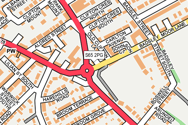
S65 2PG lies on Badsley Moor Lane in Rotherham. S65 2PG is located in the Boston Castle electoral ward, within the metropolitan district of Rotherham and the English Parliamentary constituency of Rotherham. The Sub Integrated Care Board (ICB) Location is NHS South Yorkshire ICB - 03L and the police force is South Yorkshire. This postcode has been in use since February 2009.


GetTheData
Source: OS OpenMap – Local (Ordnance Survey)
Source: OS VectorMap District (Ordnance Survey)
Licence: Open Government Licence (requires attribution)
| Easting | 443628 |
| Northing | 392410 |
| Latitude | 53.426684 |
| Longitude | -1.344897 |
GetTheData
Source: Open Postcode Geo
Licence: Open Government Licence
| Street | Badsley Moor Lane |
| Town/City | Rotherham |
| Country | England |
| Postcode District | S65 |
➜ See where S65 is on a map ➜ Where is Rotherham? | |
GetTheData
Source: Land Registry Price Paid Data
Licence: Open Government Licence
Elevation or altitude of S65 2PG as distance above sea level:
| Metres | Feet | |
|---|---|---|
| Elevation | 60m | 197ft |
Elevation is measured from the approximate centre of the postcode, to the nearest point on an OS contour line from OS Terrain 50, which has contour spacing of ten vertical metres.
➜ How high above sea level am I? Find the elevation of your current position using your device's GPS.
GetTheData
Source: Open Postcode Elevation
Licence: Open Government Licence
| Ward | Boston Castle |
| Constituency | Rotherham |
GetTheData
Source: ONS Postcode Database
Licence: Open Government Licence
| Broom Terrace (Broom Road) | Broom Valley | 82m |
| Broom Terrace (Broom Road) | Broom Valley | 114m |
| Clifton Crescent South (Clifton Lane) | Clifton | 115m |
| Wellgate (Broom Valley Road) | Broom Valley | 166m |
| Badsley Street South (Badsley Moor Lane) | Clifton | 175m |
| Rotherham Central Station | 1.2km |
| Meadowhall Station | 4.6km |
| Darnall Station | 6.5km |
GetTheData
Source: NaPTAN
Licence: Open Government Licence
GetTheData
Source: ONS Postcode Database
Licence: Open Government Licence


➜ Get more ratings from the Food Standards Agency
GetTheData
Source: Food Standards Agency
Licence: FSA terms & conditions
| Last Collection | |||
|---|---|---|---|
| Location | Mon-Fri | Sat | Distance |
| Badsley Street | 16:00 | 11:15 | 239m |
| 67 Gerrard Road | 16:00 | 11:00 | 384m |
| Broomfield Grove | 16:00 | 11:00 | 399m |
GetTheData
Source: Dracos
Licence: Creative Commons Attribution-ShareAlike
The below table lists the International Territorial Level (ITL) codes (formerly Nomenclature of Territorial Units for Statistics (NUTS) codes) and Local Administrative Units (LAU) codes for S65 2PG:
| ITL 1 Code | Name |
|---|---|
| TLE | Yorkshire and The Humber |
| ITL 2 Code | Name |
| TLE3 | South Yorkshire |
| ITL 3 Code | Name |
| TLE31 | Barnsley, Doncaster and Rotherham |
| LAU 1 Code | Name |
| E08000018 | Rotherham |
GetTheData
Source: ONS Postcode Directory
Licence: Open Government Licence
The below table lists the Census Output Area (OA), Lower Layer Super Output Area (LSOA), and Middle Layer Super Output Area (MSOA) for S65 2PG:
| Code | Name | |
|---|---|---|
| OA | E00039335 | |
| LSOA | E01007767 | Rotherham 017C |
| MSOA | E02001594 | Rotherham 017 |
GetTheData
Source: ONS Postcode Directory
Licence: Open Government Licence
| S65 2AW | Old Clifton Lane | 40m |
| S65 2AP | Old Clifton Lane | 79m |
| S60 2PA | Wellgate | 105m |
| S65 2PL | Carlton Avenue | 121m |
| S65 2AN | Garfield Mount | 128m |
| S65 2AR | Clifton Crescent South | 141m |
| S60 2QJ | Harehills Road | 149m |
| S65 2AS | Clifton Crescent North | 156m |
| S60 2QH | Broom Valley Road | 163m |
| S60 2TF | Broom Terrace | 165m |
GetTheData
Source: Open Postcode Geo; Land Registry Price Paid Data
Licence: Open Government Licence