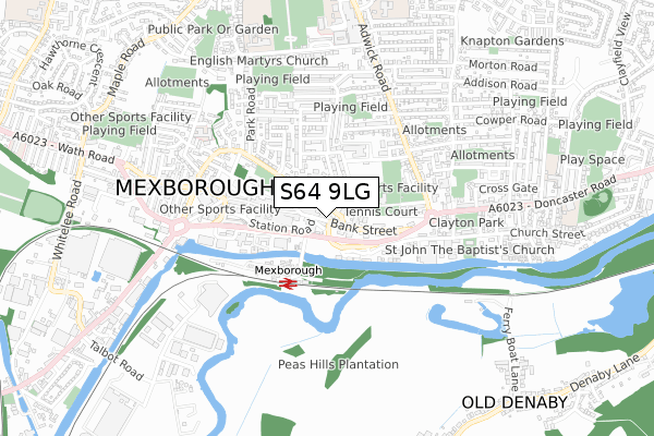
S64 9LG lies on Bank Street in Mexborough. S64 9LG is located in the Mexborough electoral ward, within the metropolitan district of Doncaster and the English Parliamentary constituency of Doncaster North. The Sub Integrated Care Board (ICB) Location is NHS South Yorkshire ICB - 02X and the police force is South Yorkshire. This postcode has been in use since January 1980.


GetTheData
Source: OS Open Zoomstack (Ordnance Survey)
Licence: Open Government Licence (requires attribution)
Attribution: Contains OS data © Crown copyright and database right 2025
Source: Open Postcode Geo
Licence: Open Government Licence (requires attribution)
Attribution: Contains OS data © Crown copyright and database right 2025; Contains Royal Mail data © Royal Mail copyright and database right 2025; Source: Office for National Statistics licensed under the Open Government Licence v.3.0
| Easting | 447430 |
| Northing | 399836 |
| Latitude | 53.493100 |
| Longitude | -1.286567 |
GetTheData
Source: Open Postcode Geo
Licence: Open Government Licence
| Street | Bank Street |
| Town/City | Mexborough |
| Country | England |
| Postcode District | S64 |
➜ See where S64 is on a map ➜ Where is Mexborough? | |
GetTheData
Source: Land Registry Price Paid Data
Licence: Open Government Licence
Elevation or altitude of S64 9LG as distance above sea level:
| Metres | Feet | |
|---|---|---|
| Elevation | 30m | 98ft |
Elevation is measured from the approximate centre of the postcode, to the nearest point on an OS contour line from OS Terrain 50, which has contour spacing of ten vertical metres.
➜ How high above sea level am I? Find the elevation of your current position using your device's GPS.
GetTheData
Source: Open Postcode Elevation
Licence: Open Government Licence
| Ward | Mexborough |
| Constituency | Doncaster North |
GetTheData
Source: ONS Postcode Database
Licence: Open Government Licence
| High Street (Bank Street) | Mexborough | 86m |
| Interchange (Station Road) | Mexborough | 371m |
| Doncaster Road (Adwick Road) | Mexborough | 376m |
| Doncaster Road (Adwick Road) | Mexborough | 390m |
| Genoa Street (Adwick Road) | Mexborough | 417m |
| Mexborough Station | 0.3km |
| Swinton (South Yorks) Station | 1.5km |
| Bolton-Upon-Dearne Station | 3.3km |
GetTheData
Source: NaPTAN
Licence: Open Government Licence
GetTheData
Source: ONS Postcode Database
Licence: Open Government Licence


➜ Get more ratings from the Food Standards Agency
GetTheData
Source: Food Standards Agency
Licence: FSA terms & conditions
| Last Collection | |||
|---|---|---|---|
| Location | Mon-Fri | Sat | Distance |
| High Street | 16:00 | 11:00 | 98m |
| Mexborough Post Office | 16:00 | 12:15 | 416m |
| Pym Road Post Office | 16:45 | 12:00 | 458m |
GetTheData
Source: Dracos
Licence: Creative Commons Attribution-ShareAlike
The below table lists the International Territorial Level (ITL) codes (formerly Nomenclature of Territorial Units for Statistics (NUTS) codes) and Local Administrative Units (LAU) codes for S64 9LG:
| ITL 1 Code | Name |
|---|---|
| TLE | Yorkshire and The Humber |
| ITL 2 Code | Name |
| TLE3 | South Yorkshire |
| ITL 3 Code | Name |
| TLE31 | Barnsley, Doncaster and Rotherham |
| LAU 1 Code | Name |
| E08000017 | Doncaster |
GetTheData
Source: ONS Postcode Directory
Licence: Open Government Licence
The below table lists the Census Output Area (OA), Lower Layer Super Output Area (LSOA), and Middle Layer Super Output Area (MSOA) for S64 9LG:
| Code | Name | |
|---|---|---|
| OA | E00038406 | |
| LSOA | E01007571 | Doncaster 031A |
| MSOA | E02001569 | Doncaster 031 |
GetTheData
Source: ONS Postcode Directory
Licence: Open Government Licence
| S64 9BA | Waddington Terrace | 84m |
| S64 9AP | High Street | 116m |
| S64 9BE | West View Road | 139m |
| S64 9JN | Hampden Road | 154m |
| S64 9BB | Cromwell Road | 157m |
| S64 9AS | High Street | 174m |
| S64 9LL | Bank Street | 183m |
| S64 9AZ | Dolcliffe Road | 219m |
| S64 9BG | Milton Road | 256m |
| S64 0EJ | Stentons Terrace | 266m |
GetTheData
Source: Open Postcode Geo; Land Registry Price Paid Data
Licence: Open Government Licence