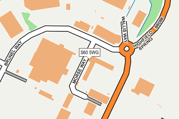
S60 5WG lies on Brindley Way in Catcliffe, Rotherham. S60 5WG is located in the Rother Vale electoral ward, within the metropolitan district of Rotherham and the English Parliamentary constituency of Rotherham. The Sub Integrated Care Board (ICB) Location is NHS South Yorkshire ICB - 03L and the police force is South Yorkshire. This postcode has been in use since September 2006.


GetTheData
Source: OS OpenMap – Local (Ordnance Survey)
Source: OS VectorMap District (Ordnance Survey)
Licence: Open Government Licence (requires attribution)
| Easting | 441452 |
| Northing | 387933 |
| Latitude | 53.386638 |
| Longitude | -1.378228 |
GetTheData
Source: Open Postcode Geo
Licence: Open Government Licence
| Street | Brindley Way |
| Locality | Catcliffe |
| Town/City | Rotherham |
| Country | England |
| Postcode District | S60 |
➜ See where S60 is on a map ➜ Where is Catcliffe? | |
GetTheData
Source: Land Registry Price Paid Data
Licence: Open Government Licence
Elevation or altitude of S60 5WG as distance above sea level:
| Metres | Feet | |
|---|---|---|
| Elevation | 60m | 197ft |
Elevation is measured from the approximate centre of the postcode, to the nearest point on an OS contour line from OS Terrain 50, which has contour spacing of ten vertical metres.
➜ How high above sea level am I? Find the elevation of your current position using your device's GPS.
GetTheData
Source: Open Postcode Elevation
Licence: Open Government Licence
| Ward | Rother Vale |
| Constituency | Rotherham |
GetTheData
Source: ONS Postcode Database
Licence: Open Government Licence
| Brunel Way (High Field Spring) | Waverley | 118m |
| Whittle Way (High Field Spring) | Waverley | 171m |
| Poplar Way (High Field Spring) | Waverley | 180m |
| Parkway (Poplar Way) | Catcliffe | 341m |
| Parkway (Poplar Way) | Catcliffe | 358m |
| Darnall Station | 2.3km |
| Woodhouse Station | 2.9km |
| Meadowhall Station | 4.1km |
GetTheData
Source: NaPTAN
Licence: Open Government Licence
GetTheData
Source: ONS Postcode Database
Licence: Open Government Licence


➜ Get more ratings from the Food Standards Agency
GetTheData
Source: Food Standards Agency
Licence: FSA terms & conditions
| Last Collection | |||
|---|---|---|---|
| Location | Mon-Fri | Sat | Distance |
| Sheffield Lane | 16:00 | 10:30 | 880m |
| Europa Drive | 17:45 | 1,057m | |
| Europa Drive | 17:45 | 09:30 | 1,059m |
GetTheData
Source: Dracos
Licence: Creative Commons Attribution-ShareAlike
The below table lists the International Territorial Level (ITL) codes (formerly Nomenclature of Territorial Units for Statistics (NUTS) codes) and Local Administrative Units (LAU) codes for S60 5WG:
| ITL 1 Code | Name |
|---|---|
| TLE | Yorkshire and The Humber |
| ITL 2 Code | Name |
| TLE3 | South Yorkshire |
| ITL 3 Code | Name |
| TLE31 | Barnsley, Doncaster and Rotherham |
| LAU 1 Code | Name |
| E08000018 | Rotherham |
GetTheData
Source: ONS Postcode Directory
Licence: Open Government Licence
The below table lists the Census Output Area (OA), Lower Layer Super Output Area (LSOA), and Middle Layer Super Output Area (MSOA) for S60 5WG:
| Code | Name | |
|---|---|---|
| OA | E00039029 | |
| LSOA | E01007699 | Rotherham 027B |
| MSOA | E02001604 | Rotherham 027 |
GetTheData
Source: ONS Postcode Directory
Licence: Open Government Licence
| S60 5BL | Whittle Way | 213m |
| S60 8WB | Cressbrook Road | 451m |
| S60 8WE | Bradfield Way | 470m |
| S60 5TR | Poplar Way | 504m |
| S60 8WF | Holmesfield Grove | 517m |
| S60 8AS | Lescar Road | 538m |
| S60 8WD | Wensley Road | 542m |
| S60 8AG | Bakewell Gardens | 543m |
| S60 8AF | Calver Way | 578m |
| S60 8AH | Peak Dale Drive | 593m |
GetTheData
Source: Open Postcode Geo; Land Registry Price Paid Data
Licence: Open Government Licence