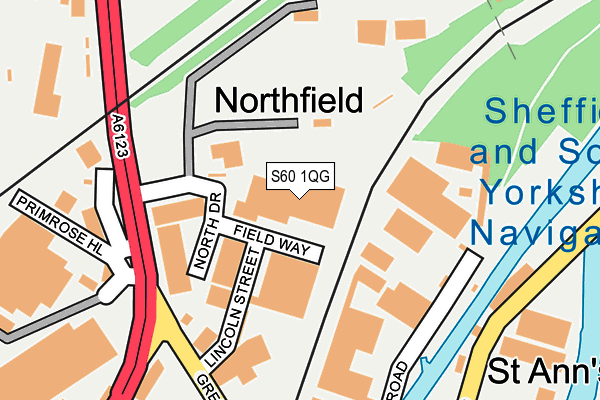
S60 1QG is located in the Rotherham West electoral ward, within the metropolitan district of Rotherham and the English Parliamentary constituency of Rotherham. The Sub Integrated Care Board (ICB) Location is NHS South Yorkshire ICB - 03L and the police force is South Yorkshire. This postcode has been in use since January 1980.


GetTheData
Source: OS OpenMap – Local (Ordnance Survey)
Source: OS VectorMap District (Ordnance Survey)
Licence: Open Government Licence (requires attribution)
| Easting | 442743 |
| Northing | 393720 |
| Latitude | 53.438549 |
| Longitude | -1.358039 |
GetTheData
Source: Open Postcode Geo
Licence: Open Government Licence
| Country | England |
| Postcode District | S60 |
➜ See where S60 is on a map ➜ Where is Rotherham? | |
GetTheData
Source: Land Registry Price Paid Data
Licence: Open Government Licence
Elevation or altitude of S60 1QG as distance above sea level:
| Metres | Feet | |
|---|---|---|
| Elevation | 30m | 98ft |
Elevation is measured from the approximate centre of the postcode, to the nearest point on an OS contour line from OS Terrain 50, which has contour spacing of ten vertical metres.
➜ How high above sea level am I? Find the elevation of your current position using your device's GPS.
GetTheData
Source: Open Postcode Elevation
Licence: Open Government Licence
| Ward | Rotherham West |
| Constituency | Rotherham |
GetTheData
Source: ONS Postcode Database
Licence: Open Government Licence
| North Drive (Greasbrough Road) | Thorn Hill | 151m |
| Primrose Hill (Greasbrough Road) | Thorn Hill | 182m |
| Greasbrough Road (Greasbrough Street) | Thorn Hill | 250m |
| Greasbrough Road (Greasbrough Street) | Thorn Hill | 264m |
| Magnham Road (Greasbrough Road) | Thorn Hill | 356m |
| Rotherham Central Station | 0.7km |
| Meadowhall Station | 4.3km |
GetTheData
Source: NaPTAN
Licence: Open Government Licence
GetTheData
Source: ONS Postcode Database
Licence: Open Government Licence


➜ Get more ratings from the Food Standards Agency
GetTheData
Source: Food Standards Agency
Licence: FSA terms & conditions
| Last Collection | |||
|---|---|---|---|
| Location | Mon-Fri | Sat | Distance |
| Ashley Business Centre | 17:00 | 247m | |
| Ashley Business Court | 18:30 | 12:15 | 249m |
| Greasborough Street | 18:30 | 533m | |
GetTheData
Source: Dracos
Licence: Creative Commons Attribution-ShareAlike
| Risk of S60 1QG flooding from rivers and sea | Low |
| ➜ S60 1QG flood map | |
GetTheData
Source: Open Flood Risk by Postcode
Licence: Open Government Licence
The below table lists the International Territorial Level (ITL) codes (formerly Nomenclature of Territorial Units for Statistics (NUTS) codes) and Local Administrative Units (LAU) codes for S60 1QG:
| ITL 1 Code | Name |
|---|---|
| TLE | Yorkshire and The Humber |
| ITL 2 Code | Name |
| TLE3 | South Yorkshire |
| ITL 3 Code | Name |
| TLE31 | Barnsley, Doncaster and Rotherham |
| LAU 1 Code | Name |
| E08000018 | Rotherham |
GetTheData
Source: ONS Postcode Directory
Licence: Open Government Licence
The below table lists the Census Output Area (OA), Lower Layer Super Output Area (LSOA), and Middle Layer Super Output Area (MSOA) for S60 1QG:
| Code | Name | |
|---|---|---|
| OA | E00039083 | |
| LSOA | E01007714 | Rotherham 017B |
| MSOA | E02001594 | Rotherham 017 |
GetTheData
Source: ONS Postcode Directory
Licence: Open Government Licence
| S60 1QF | North Drive | 84m |
| S60 1RP | Lincoln Street | 124m |
| S61 4QN | Bassingthorpe Lane | 292m |
| S60 1RU | Rawmarsh Road | 368m |
| S60 1RF | Greasbrough Street | 394m |
| S65 1BL | Effingham Street | 402m |
| S65 1RJ | St Anns Road | 439m |
| S65 1RF | Erskine Road | 497m |
| S65 1RG | Owen Close | 510m |
| S65 1RL | St Anns Road | 517m |
GetTheData
Source: Open Postcode Geo; Land Registry Price Paid Data
Licence: Open Government Licence