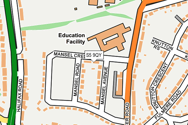
S5 9QY is located in the Southey electoral ward, within the metropolitan district of Sheffield and the English Parliamentary constituency of Sheffield, Brightside and Hillsborough. The Sub Integrated Care Board (ICB) Location is NHS South Yorkshire ICB - 03N and the police force is South Yorkshire. This postcode has been in use since July 2017.


GetTheData
Source: OS OpenMap – Local (Ordnance Survey)
Source: OS VectorMap District (Ordnance Survey)
Licence: Open Government Licence (requires attribution)
| Easting | 433878 |
| Northing | 392421 |
| Latitude | 53.427515 |
| Longitude | -1.491619 |
GetTheData
Source: Open Postcode Geo
Licence: Open Government Licence
| Country | England |
| Postcode District | S5 |
➜ See where S5 is on a map ➜ Where is Sheffield? | |
GetTheData
Source: Land Registry Price Paid Data
Licence: Open Government Licence
| Ward | Southey |
| Constituency | Sheffield, Brightside And Hillsborough |
GetTheData
Source: ONS Postcode Database
Licence: Open Government Licence
| Halifax Road (Chaucer Road) | Parson Cross | 40m |
| Chaucer Close (Chaucer Road) | Parson Cross | 64m |
| Chaucer Road (Halifax Road) | Fox Hill | 78m |
| Wilcox Road (Halifax Road) | Fox Hill | 93m |
| Halifax Road (Wilcox Road) | Fox Hill | 161m |
| Middlewood (Sheffield Supertram) (Middlewood Road) | Middlewood | 1,784m |
| Chapeltown Station | 4.2km |
GetTheData
Source: NaPTAN
Licence: Open Government Licence
GetTheData
Source: ONS Postcode Database
Licence: Open Government Licence


➜ Get more ratings from the Food Standards Agency
GetTheData
Source: Food Standards Agency
Licence: FSA terms & conditions
| Last Collection | |||
|---|---|---|---|
| Location | Mon-Fri | Sat | Distance |
| Wilcox Road | 17:30 | 09:30 | 182m |
| 495 Deerlands Avenue | 17:30 | 09:30 | 286m |
| 76 Keats Road | 17:30 | 09:30 | 562m |
GetTheData
Source: Dracos
Licence: Creative Commons Attribution-ShareAlike
The below table lists the International Territorial Level (ITL) codes (formerly Nomenclature of Territorial Units for Statistics (NUTS) codes) and Local Administrative Units (LAU) codes for S5 9QY:
| ITL 1 Code | Name |
|---|---|
| TLE | Yorkshire and The Humber |
| ITL 2 Code | Name |
| TLE3 | South Yorkshire |
| ITL 3 Code | Name |
| TLE32 | Sheffield |
| LAU 1 Code | Name |
| E08000019 | Sheffield |
GetTheData
Source: ONS Postcode Directory
Licence: Open Government Licence
The below table lists the Census Output Area (OA), Lower Layer Super Output Area (LSOA), and Middle Layer Super Output Area (MSOA) for S5 9QY:
| Code | Name | |
|---|---|---|
| OA | E00041164 | |
| LSOA | E01008118 | Sheffield 009E |
| MSOA | E02001619 | Sheffield 009 |
GetTheData
Source: ONS Postcode Directory
Licence: Open Government Licence
| S5 9QD | Chaucer Close | 129m |
| S5 9QJ | Chaucer Road | 148m |
| S6 1BS | Wilcox Close | 170m |
| S6 1AE | Halifax Road | 190m |
| S6 1AF | Halifax Road | 202m |
| S6 1AB | Halifax Road | 205m |
| S5 9QE | Chaucer Close | 216m |
| S6 1AA | Halifax Road | 232m |
| S6 1AW | Cowper Crescent | 237m |
| S5 9QG | Deerlands Avenue | 266m |
GetTheData
Source: Open Postcode Geo; Land Registry Price Paid Data
Licence: Open Government Licence