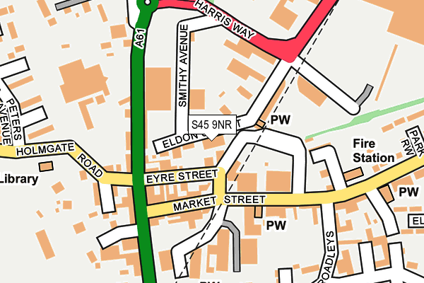
S45 9NR is located in the Clay Cross North electoral ward, within the local authority district of North East Derbyshire and the English Parliamentary constituency of North East Derbyshire. The Sub Integrated Care Board (ICB) Location is NHS Derby and Derbyshire ICB - 15M and the police force is Derbyshire. This postcode has been in use since January 1980.


GetTheData
Source: OS OpenMap – Local (Ordnance Survey)
Source: OS VectorMap District (Ordnance Survey)
Licence: Open Government Licence (requires attribution)
| Easting | 439249 |
| Northing | 363534 |
| Latitude | 53.167483 |
| Longitude | -1.414353 |
GetTheData
Source: Open Postcode Geo
Licence: Open Government Licence
| Country | England |
| Postcode District | S45 |
➜ See where S45 is on a map ➜ Where is Clay Cross? | |
GetTheData
Source: Land Registry Price Paid Data
Licence: Open Government Licence
Elevation or altitude of S45 9NR as distance above sea level:
| Metres | Feet | |
|---|---|---|
| Elevation | 140m | 459ft |
Elevation is measured from the approximate centre of the postcode, to the nearest point on an OS contour line from OS Terrain 50, which has contour spacing of ten vertical metres.
➜ How high above sea level am I? Find the elevation of your current position using your device's GPS.
GetTheData
Source: Open Postcode Elevation
Licence: Open Government Licence
| Ward | Clay Cross North |
| Constituency | North East Derbyshire |
GetTheData
Source: ONS Postcode Database
Licence: Open Government Licence
| Eyre Street | Clay Cross | 80m |
| Baptist Church (Market Street) | Clay Cross | 98m |
| Eyre Street (High Street) | Clay Cross | 115m |
| Petrol Station (Derby Road) | Clay Cross | 130m |
| Holmgate Road Library (Holmgate Road) | Clay Cross | 186m |
GetTheData
Source: NaPTAN
Licence: Open Government Licence
GetTheData
Source: ONS Postcode Database
Licence: Open Government Licence


➜ Get more ratings from the Food Standards Agency
GetTheData
Source: Food Standards Agency
Licence: FSA terms & conditions
| Last Collection | |||
|---|---|---|---|
| Location | Mon-Fri | Sat | Distance |
| Market Street | 16:00 | 09:45 | 229m |
| Broadleys | 16:00 | 10:30 | 333m |
| Bridge Street | 18:30 | 10:30 | 354m |
GetTheData
Source: Dracos
Licence: Creative Commons Attribution-ShareAlike
The below table lists the International Territorial Level (ITL) codes (formerly Nomenclature of Territorial Units for Statistics (NUTS) codes) and Local Administrative Units (LAU) codes for S45 9NR:
| ITL 1 Code | Name |
|---|---|
| TLF | East Midlands (England) |
| ITL 2 Code | Name |
| TLF1 | Derbyshire and Nottinghamshire |
| ITL 3 Code | Name |
| TLF12 | East Derbyshire |
| LAU 1 Code | Name |
| E07000038 | North East Derbyshire |
GetTheData
Source: ONS Postcode Directory
Licence: Open Government Licence
The below table lists the Census Output Area (OA), Lower Layer Super Output Area (LSOA), and Middle Layer Super Output Area (MSOA) for S45 9NR:
| Code | Name | |
|---|---|---|
| OA | E00100059 | |
| LSOA | E01019775 | North East Derbyshire 012B |
| MSOA | E02004116 | North East Derbyshire 012 |
GetTheData
Source: ONS Postcode Directory
Licence: Open Government Licence
| S45 9PE | Eldon Street | 33m |
| S45 9NS | Eyre Street | 66m |
| S45 9JE | Market Street | 93m |
| S45 9DY | High Street | 102m |
| S45 9DW | High Street | 117m |
| S45 9JG | Waterloo Street | 149m |
| S45 9PQ | Hill Street | 175m |
| S45 9JQ | Market Street | 213m |
| S45 9JL | Broadleys | 217m |
| S45 9DZ | High Street | 222m |
GetTheData
Source: Open Postcode Geo; Land Registry Price Paid Data
Licence: Open Government Licence