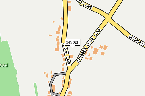
S45 0BF is located in the Ashover electoral ward, within the local authority district of North East Derbyshire and the English Parliamentary constituency of North East Derbyshire. The Sub Integrated Care Board (ICB) Location is NHS Derby and Derbyshire ICB - 15M and the police force is Derbyshire. This postcode has been in use since March 2017.


GetTheData
Source: OS OpenMap – Local (Ordnance Survey)
Source: OS VectorMap District (Ordnance Survey)
Licence: Open Government Licence (requires attribution)
| Easting | 434215 |
| Northing | 363274 |
| Latitude | 53.165511 |
| Longitude | -1.489676 |
GetTheData
Source: Open Postcode Geo
Licence: Open Government Licence
| Country | England |
| Postcode District | S45 |
➜ See where S45 is on a map | |
GetTheData
Source: Land Registry Price Paid Data
Licence: Open Government Licence
| Ward | Ashover |
| Constituency | North East Derbyshire |
GetTheData
Source: ONS Postcode Database
Licence: Open Government Licence
| Butts Road (Ashover Road) | Ashover | 353m |
| West Edge Close (Ashover Road) | Kelstedge | 436m |
| Narrowleys Lane | Ashover | 439m |
| West Edge Close (Ashover Road) | Kelstedge | 458m |
| Primary School (Narrowleys Lane) | Ashover | 575m |
| Matlock Station | 5.5km |
| Matlock Bath Station | 6.6km |
GetTheData
Source: NaPTAN
Licence: Open Government Licence
GetTheData
Source: ONS Postcode Database
Licence: Open Government Licence


➜ Get more ratings from the Food Standards Agency
GetTheData
Source: Food Standards Agency
Licence: FSA terms & conditions
| Last Collection | |||
|---|---|---|---|
| Location | Mon-Fri | Sat | Distance |
| Kelstedge Lane | 16:00 | 09:45 | 595m |
| Marsh Green Lane | 16:00 | 10:30 | 622m |
| Church Street | 16:00 | 10:30 | 669m |
GetTheData
Source: Dracos
Licence: Creative Commons Attribution-ShareAlike
The below table lists the International Territorial Level (ITL) codes (formerly Nomenclature of Territorial Units for Statistics (NUTS) codes) and Local Administrative Units (LAU) codes for S45 0BF:
| ITL 1 Code | Name |
|---|---|
| TLF | East Midlands (England) |
| ITL 2 Code | Name |
| TLF1 | Derbyshire and Nottinghamshire |
| ITL 3 Code | Name |
| TLF12 | East Derbyshire |
| LAU 1 Code | Name |
| E07000038 | North East Derbyshire |
GetTheData
Source: ONS Postcode Directory
Licence: Open Government Licence
The below table lists the Census Output Area (OA), Lower Layer Super Output Area (LSOA), and Middle Layer Super Output Area (MSOA) for S45 0BF:
| Code | Name | |
|---|---|---|
| OA | E00100026 | |
| LSOA | E01019769 | North East Derbyshire 010A |
| MSOA | E02004114 | North East Derbyshire 010 |
GetTheData
Source: ONS Postcode Directory
Licence: Open Government Licence
| S45 0HW | Butts Road | 177m |
| S45 0AU | Narrowleys Lane | 487m |
| S45 0DS | Westedge Close | 495m |
| S45 0DT | Ashover Road | 519m |
| S45 0DR | Marsh Green Lane | 520m |
| S45 0AY | The Barley Close | 536m |
| S45 0DU | The Causeway | 558m |
| S45 0DZ | Amber Lane | 589m |
| S45 0AX | Butts Road | 598m |
| S45 0DW | Causeway Houses | 600m |
GetTheData
Source: Open Postcode Geo; Land Registry Price Paid Data
Licence: Open Government Licence