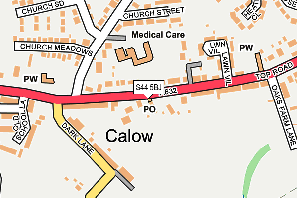
S44 5BJ is located in the Sutton electoral ward, within the local authority district of North East Derbyshire and the English Parliamentary constituency of Bolsover. The Sub Integrated Care Board (ICB) Location is NHS Derby and Derbyshire ICB - 15M and the police force is Derbyshire. This postcode has been in use since February 2017.


GetTheData
Source: OS OpenMap – Local (Ordnance Survey)
Source: OS VectorMap District (Ordnance Survey)
Licence: Open Government Licence (requires attribution)
| Easting | 440988 |
| Northing | 370915 |
| Latitude | 53.233715 |
| Longitude | -1.387394 |
GetTheData
Source: Open Postcode Geo
Licence: Open Government Licence
| Country | England |
| Postcode District | S44 |
➜ See where S44 is on a map ➜ Where is Calow? | |
GetTheData
Source: Land Registry Price Paid Data
Licence: Open Government Licence
| Ward | Sutton |
| Constituency | Bolsover |
GetTheData
Source: ONS Postcode Database
Licence: Open Government Licence
| Lawn Villas (Top Road) | Calow | 135m |
| Lawn Villas (Top Road) | Calow | 177m |
| North Road Top (North Road) | Calow | 194m |
| North Road Top (Church Lane) | Calow | 206m |
| Church (Chesterfield Road) | Calow | 212m |
| Chesterfield Station | 2.2km |
GetTheData
Source: NaPTAN
Licence: Open Government Licence
GetTheData
Source: ONS Postcode Database
Licence: Open Government Licence


➜ Get more ratings from the Food Standards Agency
GetTheData
Source: Food Standards Agency
Licence: FSA terms & conditions
| Last Collection | |||
|---|---|---|---|
| Location | Mon-Fri | Sat | Distance |
| Top Road | 16:00 | 10:00 | 11m |
| Allpits Road | 16:00 | 10:15 | 531m |
| Calow Post Office | 16:00 | 10:00 | 677m |
GetTheData
Source: Dracos
Licence: Creative Commons Attribution-ShareAlike
The below table lists the International Territorial Level (ITL) codes (formerly Nomenclature of Territorial Units for Statistics (NUTS) codes) and Local Administrative Units (LAU) codes for S44 5BJ:
| ITL 1 Code | Name |
|---|---|
| TLF | East Midlands (England) |
| ITL 2 Code | Name |
| TLF1 | Derbyshire and Nottinghamshire |
| ITL 3 Code | Name |
| TLF12 | East Derbyshire |
| LAU 1 Code | Name |
| E07000038 | North East Derbyshire |
GetTheData
Source: ONS Postcode Directory
Licence: Open Government Licence
The below table lists the Census Output Area (OA), Lower Layer Super Output Area (LSOA), and Middle Layer Super Output Area (MSOA) for S44 5BJ:
| Code | Name | |
|---|---|---|
| OA | E00100313 | |
| LSOA | E01019821 | North East Derbyshire 007B |
| MSOA | E02004111 | North East Derbyshire 007 |
GetTheData
Source: ONS Postcode Directory
Licence: Open Government Licence
| S44 5AB | Top Road | 61m |
| S44 5AA | Top Road | 122m |
| S44 5SY | Top Road | 126m |
| S44 5AG | Church Lane | 131m |
| S44 5AD | Dark Lane | 149m |
| S44 5SZ | Lawn Villas | 153m |
| S44 5AQ | Church Street | 159m |
| S44 5BP | Church Meadows | 211m |
| S44 5BE | North Road | 217m |
| S44 5BH | Churchside | 261m |
GetTheData
Source: Open Postcode Geo; Land Registry Price Paid Data
Licence: Open Government Licence