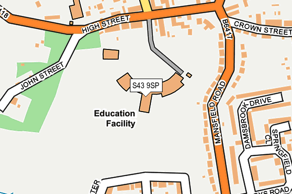
S43 9SP is located in the Clowne West electoral ward, within the local authority district of Bolsover and the English Parliamentary constituency of Bolsover. The Sub Integrated Care Board (ICB) Location is NHS Derby and Derbyshire ICB - 15M and the police force is Derbyshire. This postcode has been in use since January 2013.


GetTheData
Source: OS OpenMap – Local (Ordnance Survey)
Source: OS VectorMap District (Ordnance Survey)
Licence: Open Government Licence (requires attribution)
| Easting | 448876 |
| Northing | 375162 |
| Latitude | 53.271202 |
| Longitude | -1.268582 |
GetTheData
Source: Open Postcode Geo
Licence: Open Government Licence
| Country | England |
| Postcode District | S43 |
➜ See where S43 is on a map ➜ Where is Clowne? | |
GetTheData
Source: Land Registry Price Paid Data
Licence: Open Government Licence
Elevation or altitude of S43 9SP as distance above sea level:
| Metres | Feet | |
|---|---|---|
| Elevation | 140m | 459ft |
Elevation is measured from the approximate centre of the postcode, to the nearest point on an OS contour line from OS Terrain 50, which has contour spacing of ten vertical metres.
➜ How high above sea level am I? Find the elevation of your current position using your device's GPS.
GetTheData
Source: Open Postcode Elevation
Licence: Open Government Licence
| Ward | Clowne West |
| Constituency | Bolsover |
GetTheData
Source: ONS Postcode Database
Licence: Open Government Licence
| Angel Inn (High Street) | Clowne | 173m |
| Angel Inn (High Street) | Clowne | 213m |
| Boughton Lane Bottom (Boughton Lane) | Clowne | 231m |
| Miners Welfare (High Street) | Clowne | 362m |
| Chestnut Drive (Boughton Lane) | Clowne | 366m |
| Creswell (Derbys) Station | 3.6km |
| Whitwell (Derbys) Station | 4.7km |
| Langwith - Whaley Thorns Station | 5.9km |
GetTheData
Source: NaPTAN
Licence: Open Government Licence
GetTheData
Source: ONS Postcode Database
Licence: Open Government Licence


➜ Get more ratings from the Food Standards Agency
GetTheData
Source: Food Standards Agency
Licence: FSA terms & conditions
| Last Collection | |||
|---|---|---|---|
| Location | Mon-Fri | Sat | Distance |
| 87 High Street | 16:00 | 10:00 | 184m |
| Clowne Post Office | 16:00 | 10:30 | 549m |
| Ridgeway West | 16:00 | 10:30 | 725m |
GetTheData
Source: Dracos
Licence: Creative Commons Attribution-ShareAlike
The below table lists the International Territorial Level (ITL) codes (formerly Nomenclature of Territorial Units for Statistics (NUTS) codes) and Local Administrative Units (LAU) codes for S43 9SP:
| ITL 1 Code | Name |
|---|---|
| TLF | East Midlands (England) |
| ITL 2 Code | Name |
| TLF1 | Derbyshire and Nottinghamshire |
| ITL 3 Code | Name |
| TLF12 | East Derbyshire |
| LAU 1 Code | Name |
| E07000033 | Bolsover |
GetTheData
Source: ONS Postcode Directory
Licence: Open Government Licence
The below table lists the Census Output Area (OA), Lower Layer Super Output Area (LSOA), and Middle Layer Super Output Area (MSOA) for S43 9SP:
| Code | Name | |
|---|---|---|
| OA | E00098587 | |
| LSOA | E01019494 | Bolsover 001E |
| MSOA | E02004045 | Bolsover 001 |
GetTheData
Source: ONS Postcode Directory
Licence: Open Government Licence
| S43 4DH | Mansfield Road | 136m |
| S43 4JX | High Street | 153m |
| S43 4DJ | Mansfield Road | 180m |
| S43 4JQ | High Street | 182m |
| S43 4FF | Harvester Way | 186m |
| S43 4FQ | Orange Birch Close | 217m |
| S43 4DE | Damsbrook Drive | 221m |
| S43 4DL | Crown Street | 247m |
| S43 4JU | High Street | 268m |
| S43 4DD | Craggs Drive | 270m |
GetTheData
Source: Open Postcode Geo; Land Registry Price Paid Data
Licence: Open Government Licence