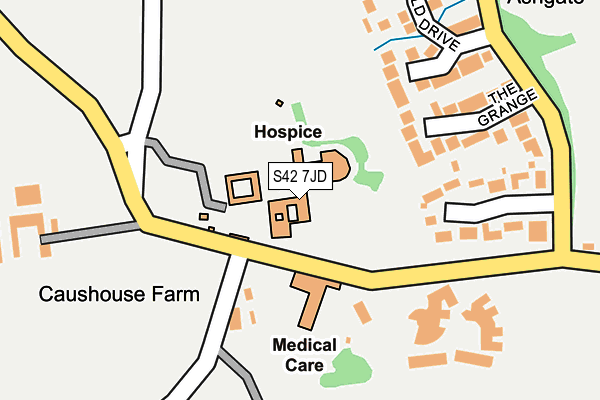
S42 7JD is located in the Brampton & Walton electoral ward, within the local authority district of North East Derbyshire and the English Parliamentary constituency of North East Derbyshire. The Sub Integrated Care Board (ICB) Location is NHS Derby and Derbyshire ICB - 15M and the police force is Derbyshire. This postcode has been in use since January 1980.


GetTheData
Source: OS OpenMap – Local (Ordnance Survey)
Source: OS VectorMap District (Ordnance Survey)
Licence: Open Government Licence (requires attribution)
| Easting | 434826 |
| Northing | 371612 |
| Latitude | 53.240399 |
| Longitude | -1.479633 |
GetTheData
Source: Open Postcode Geo
Licence: Open Government Licence
| Country | England |
| Postcode District | S42 |
➜ See where S42 is on a map ➜ Where is Chesterfield? | |
GetTheData
Source: Land Registry Price Paid Data
Licence: Open Government Licence
Elevation or altitude of S42 7JD as distance above sea level:
| Metres | Feet | |
|---|---|---|
| Elevation | 140m | 459ft |
Elevation is measured from the approximate centre of the postcode, to the nearest point on an OS contour line from OS Terrain 50, which has contour spacing of ten vertical metres.
➜ How high above sea level am I? Find the elevation of your current position using your device's GPS.
GetTheData
Source: Open Postcode Elevation
Licence: Open Government Licence
| Ward | Brampton & Walton |
| Constituency | North East Derbyshire |
GetTheData
Source: ONS Postcode Database
Licence: Open Government Licence
| Hospice (Ashgate Road) | Ashgate | 90m |
| Hospice (Ashgate Road) | Ashgate | 103m |
| Linacre Road (Ashgate Road) | Ashgate | 232m |
| The Grange (Linacre Road) | Holme Hall | 261m |
| The Grange (Linacre Road) | Holme Hall | 268m |
| Chesterfield Station | 4km |
GetTheData
Source: NaPTAN
Licence: Open Government Licence
GetTheData
Source: ONS Postcode Database
Licence: Open Government Licence


➜ Get more ratings from the Food Standards Agency
GetTheData
Source: Food Standards Agency
Licence: FSA terms & conditions
| Last Collection | |||
|---|---|---|---|
| Location | Mon-Fri | Sat | Distance |
| Ashgate Road | 16:00 | 09:00 | 74m |
| 80 Brushfield Road | 16:00 | 11:00 | 783m |
| Holme Hall Post Office | 17:00 | 11:00 | 832m |
GetTheData
Source: Dracos
Licence: Creative Commons Attribution-ShareAlike
The below table lists the International Territorial Level (ITL) codes (formerly Nomenclature of Territorial Units for Statistics (NUTS) codes) and Local Administrative Units (LAU) codes for S42 7JD:
| ITL 1 Code | Name |
|---|---|
| TLF | East Midlands (England) |
| ITL 2 Code | Name |
| TLF1 | Derbyshire and Nottinghamshire |
| ITL 3 Code | Name |
| TLF12 | East Derbyshire |
| LAU 1 Code | Name |
| E07000038 | North East Derbyshire |
GetTheData
Source: ONS Postcode Directory
Licence: Open Government Licence
The below table lists the Census Output Area (OA), Lower Layer Super Output Area (LSOA), and Middle Layer Super Output Area (MSOA) for S42 7JD:
| Code | Name | |
|---|---|---|
| OA | E00100040 | |
| LSOA | E01019771 | North East Derbyshire 008A |
| MSOA | E02004112 | North East Derbyshire 008 |
GetTheData
Source: ONS Postcode Directory
Licence: Open Government Licence
| S42 7JE | Ashgate Road | 82m |
| S42 7PT | Fairfield Court | 168m |
| S42 7PS | The Grange | 177m |
| S42 7JB | Woodnook Close | 197m |
| S42 7PZ | Woodnook Way | 207m |
| S42 7PU | Fairfield Drive | 238m |
| S42 7PX | Meadow Rise | 249m |
| S42 7PY | Thorne Close | 289m |
| S42 7PW | Loundsley Court | 331m |
| S42 7JL | Abbeyhill Close | 388m |
GetTheData
Source: Open Postcode Geo; Land Registry Price Paid Data
Licence: Open Government Licence