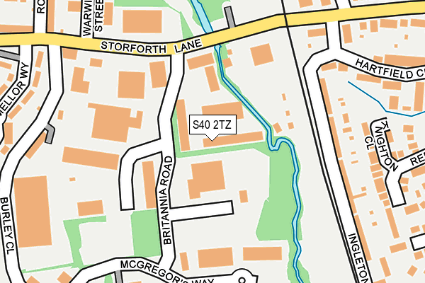
S40 2TZ is located in the Rother electoral ward, within the local authority district of Chesterfield and the English Parliamentary constituency of Chesterfield. The Sub Integrated Care Board (ICB) Location is NHS Derby and Derbyshire ICB - 15M and the police force is Derbyshire. This postcode has been in use since July 1983.


GetTheData
Source: OS OpenMap – Local (Ordnance Survey)
Source: OS VectorMap District (Ordnance Survey)
Licence: Open Government Licence (requires attribution)
| Easting | 438701 |
| Northing | 369241 |
| Latitude | 53.218839 |
| Longitude | -1.421859 |
GetTheData
Source: Open Postcode Geo
Licence: Open Government Licence
| Country | England |
| Postcode District | S40 |
➜ See where S40 is on a map ➜ Where is Chesterfield? | |
GetTheData
Source: Land Registry Price Paid Data
Licence: Open Government Licence
Elevation or altitude of S40 2TZ as distance above sea level:
| Metres | Feet | |
|---|---|---|
| Elevation | 80m | 262ft |
Elevation is measured from the approximate centre of the postcode, to the nearest point on an OS contour line from OS Terrain 50, which has contour spacing of ten vertical metres.
➜ How high above sea level am I? Find the elevation of your current position using your device's GPS.
GetTheData
Source: Open Postcode Elevation
Licence: Open Government Licence
| Ward | Rother |
| Constituency | Chesterfield |
GetTheData
Source: ONS Postcode Database
Licence: Open Government Licence
| Brittania Road (Storforth Lane) | Birdholme | 145m |
| Brittania Road (Storforth Lane) | Birdholme | 158m |
| Trading Estate (Storforth Lane) | Hasland | 234m |
| Mellor Way (Storforth Lane) | Birdholme | 257m |
| Trading Estate (Storforth Lane) | Hasland | 270m |
| Chesterfield Station | 2.2km |
GetTheData
Source: NaPTAN
Licence: Open Government Licence
| Median download speed | 63.4Mbps |
| Average download speed | 60.8Mbps |
| Maximum download speed | 80.00Mbps |
| Median upload speed | 13.2Mbps |
| Average upload speed | 13.8Mbps |
| Maximum upload speed | 20.00Mbps |
GetTheData
Source: Ofcom
Licence: Ofcom Terms of Use (requires attribution)
Estimated total energy consumption in S40 2TZ by fuel type, 2015.
| Consumption (kWh) | 244,898 |
|---|---|
| Meter count | 15 |
| Mean (kWh/meter) | 16,327 |
| Median (kWh/meter) | 13,405 |
GetTheData
Source: Postcode level gas estimates: 2015 (experimental)
Source: Postcode level electricity estimates: 2015 (experimental)
Licence: Open Government Licence
GetTheData
Source: ONS Postcode Database
Licence: Open Government Licence


➜ Get more ratings from the Food Standards Agency
GetTheData
Source: Food Standards Agency
Licence: FSA terms & conditions
| Last Collection | |||
|---|---|---|---|
| Location | Mon-Fri | Sat | Distance |
| Birdholme Post Office | 17:00 | 11:30 | 381m |
| Langer Lane | 17:15 | 11:45 | 477m |
| Hasland Hall | 17:15 | 10:00 | 576m |
GetTheData
Source: Dracos
Licence: Creative Commons Attribution-ShareAlike
| Risk of S40 2TZ flooding from rivers and sea | Medium |
| ➜ S40 2TZ flood map | |
GetTheData
Source: Open Flood Risk by Postcode
Licence: Open Government Licence
The below table lists the International Territorial Level (ITL) codes (formerly Nomenclature of Territorial Units for Statistics (NUTS) codes) and Local Administrative Units (LAU) codes for S40 2TZ:
| ITL 1 Code | Name |
|---|---|
| TLF | East Midlands (England) |
| ITL 2 Code | Name |
| TLF1 | Derbyshire and Nottinghamshire |
| ITL 3 Code | Name |
| TLF12 | East Derbyshire |
| LAU 1 Code | Name |
| E07000034 | Chesterfield |
GetTheData
Source: ONS Postcode Directory
Licence: Open Government Licence
The below table lists the Census Output Area (OA), Lower Layer Super Output Area (LSOA), and Middle Layer Super Output Area (MSOA) for S40 2TZ:
| Code | Name | |
|---|---|---|
| OA | E00098858 | |
| LSOA | E01019548 | Chesterfield 012D |
| MSOA | E02004066 | Chesterfield 012 |
GetTheData
Source: ONS Postcode Directory
Licence: Open Government Licence
| S41 0RD | North Terrace | 170m |
| S41 0RE | Traffic Terrace | 170m |
| S41 0RF | Railway Terrace | 201m |
| S41 0XL | Knighton Close | 222m |
| S41 0NT | Ingleton Road | 238m |
| S41 0PH | Midland Terrace | 251m |
| S40 2UA | Mellor Way | 287m |
| S41 0NU | Hartfield Close | 294m |
| S41 0QE | Hartfield Court | 296m |
| S41 0UA | Midland Court | 307m |
GetTheData
Source: Open Postcode Geo; Land Registry Price Paid Data
Licence: Open Government Licence