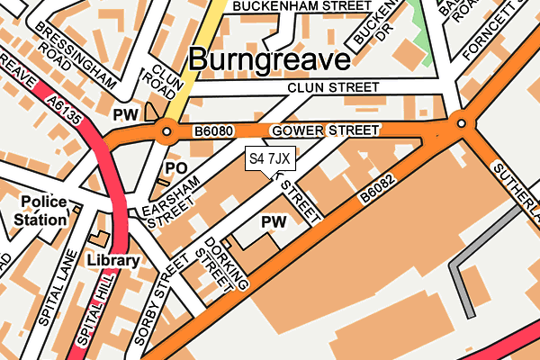
S4 7JX lies on Kirk Street in Sheffield. S4 7JX is located in the Burngreave electoral ward, within the metropolitan district of Sheffield and the English Parliamentary constituency of Sheffield, Brightside and Hillsborough. The Sub Integrated Care Board (ICB) Location is NHS South Yorkshire ICB - 03N and the police force is South Yorkshire. This postcode has been in use since December 1994.


GetTheData
Source: OS OpenMap – Local (Ordnance Survey)
Source: OS VectorMap District (Ordnance Survey)
Licence: Open Government Licence (requires attribution)
| Easting | 436296 |
| Northing | 388547 |
| Latitude | 53.392535 |
| Longitude | -1.455674 |
GetTheData
Source: Open Postcode Geo
Licence: Open Government Licence
| Street | Kirk Street |
| Town/City | Sheffield |
| Country | England |
| Postcode District | S4 |
➜ See where S4 is on a map ➜ Where is Sheffield? | |
GetTheData
Source: Land Registry Price Paid Data
Licence: Open Government Licence
Elevation or altitude of S4 7JX as distance above sea level:
| Metres | Feet | |
|---|---|---|
| Elevation | 50m | 164ft |
Elevation is measured from the approximate centre of the postcode, to the nearest point on an OS contour line from OS Terrain 50, which has contour spacing of ten vertical metres.
➜ How high above sea level am I? Find the elevation of your current position using your device's GPS.
GetTheData
Source: Open Postcode Elevation
Licence: Open Government Licence
| Ward | Burngreave |
| Constituency | Sheffield, Brightside And Hillsborough |
GetTheData
Source: ONS Postcode Database
Licence: Open Government Licence
27, KIRK STREET, SHEFFIELD, S4 7JX 2009 27 MAR £105,000 |
27, KIRK STREET, SHEFFIELD, S4 7JX 2004 19 APR £71,500 |
27, KIRK STREET, SHEFFIELD, S4 7JX 1997 4 AUG £65,500 |
GetTheData
Source: HM Land Registry Price Paid Data
Licence: Contains HM Land Registry data © Crown copyright and database right 2025. This data is licensed under the Open Government Licence v3.0.
| Gower Street (Ellesmere Road) | Burngreave | 128m |
| Gower Street (Ellesmere Road) | Burngreave | 141m |
| Gower Street (Burngreave Road) | Burngreave | 166m |
| Hallcar Street (Spital Hill) | Burngreave | 191m |
| Buckenham Street (Ellesmere Road) | Burngreave | 258m |
| Hyde Park (Sheffield Supertram) (Cricket Inn Road) | Hyde Park | 905m |
| Cricket Inn Road (Sheffield Supertram) (Cricket Inn Road) | Park Hill | 1,122m |
| Fitzalan Sq - Ponds Forge (Sheffield Supertram) (Commercial Street) | Sheffield Centre | 1,174m |
| Nunnery Square (Sheffield Supertram) (Nunnery Square) | Attercliffe | 1,210m |
| Castle Square (Sheffield Supertram) (Jct Of Arundel Gate And Angel Street) | Sheffield Centre | 1,256m |
| Sheffield Station | 1.6km |
| Darnall Station | 3km |
| Meadowhall Station | 4km |
GetTheData
Source: NaPTAN
Licence: Open Government Licence
GetTheData
Source: ONS Postcode Database
Licence: Open Government Licence


➜ Get more ratings from the Food Standards Agency
GetTheData
Source: Food Standards Agency
Licence: FSA terms & conditions
| Last Collection | |||
|---|---|---|---|
| Location | Mon-Fri | Sat | Distance |
| Ellesmere Road Post Office | 17:45 | 12:00 | 121m |
| Verdon Street Post Office | 17:45 | 12:00 | 577m |
| Lyons Street | 17:45 | 10:30 | 598m |
GetTheData
Source: Dracos
Licence: Creative Commons Attribution-ShareAlike
The below table lists the International Territorial Level (ITL) codes (formerly Nomenclature of Territorial Units for Statistics (NUTS) codes) and Local Administrative Units (LAU) codes for S4 7JX:
| ITL 1 Code | Name |
|---|---|
| TLE | Yorkshire and The Humber |
| ITL 2 Code | Name |
| TLE3 | South Yorkshire |
| ITL 3 Code | Name |
| TLE32 | Sheffield |
| LAU 1 Code | Name |
| E08000019 | Sheffield |
GetTheData
Source: ONS Postcode Directory
Licence: Open Government Licence
The below table lists the Census Output Area (OA), Lower Layer Super Output Area (LSOA), and Middle Layer Super Output Area (MSOA) for S4 7JX:
| Code | Name | |
|---|---|---|
| OA | E00172431 | |
| LSOA | E01033269 | Sheffield 022G |
| MSOA | E02001632 | Sheffield 022 |
GetTheData
Source: ONS Postcode Directory
Licence: Open Government Licence
| S4 7LB | Sorby Street | 39m |
| S4 7LS | Earsham Street | 103m |
| S4 7LA | Sorby Street | 105m |
| S4 7JB | Ellesmere Road | 119m |
| S4 7JS | Clun Street | 123m |
| S4 7JD | Ellesmere Road | 144m |
| S4 7JR | Ditchingham Street | 152m |
| S4 7HA | Gower Street | 163m |
| S4 7LT | Buckenham Drive | 190m |
| S4 7JQ | Buckenham Street | 192m |
GetTheData
Source: Open Postcode Geo; Land Registry Price Paid Data
Licence: Open Government Licence