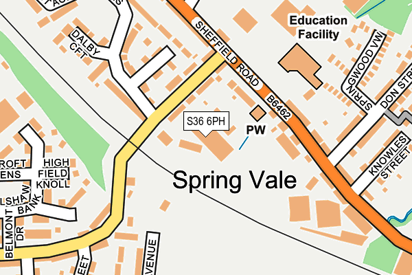
S36 6PH is located in the Penistone West electoral ward, within the metropolitan district of Barnsley and the English Parliamentary constituency of Penistone and Stocksbridge. The Sub Integrated Care Board (ICB) Location is NHS South Yorkshire ICB - 02P and the police force is South Yorkshire. This postcode has been in use since June 1997.


GetTheData
Source: OS OpenMap – Local (Ordnance Survey)
Source: OS VectorMap District (Ordnance Survey)
Licence: Open Government Licence (requires attribution)
| Easting | 425565 |
| Northing | 402932 |
| Latitude | 53.522440 |
| Longitude | -1.615870 |
GetTheData
Source: Open Postcode Geo
Licence: Open Government Licence
| Country | England |
| Postcode District | S36 |
➜ See where S36 is on a map ➜ Where is Penistone? | |
GetTheData
Source: Land Registry Price Paid Data
Licence: Open Government Licence
Elevation or altitude of S36 6PH as distance above sea level:
| Metres | Feet | |
|---|---|---|
| Elevation | 210m | 689ft |
Elevation is measured from the approximate centre of the postcode, to the nearest point on an OS contour line from OS Terrain 50, which has contour spacing of ten vertical metres.
➜ How high above sea level am I? Find the elevation of your current position using your device's GPS.
GetTheData
Source: Open Postcode Elevation
Licence: Open Government Licence
| Ward | Penistone West |
| Constituency | Penistone And Stocksbridge |
GetTheData
Source: ONS Postcode Database
Licence: Open Government Licence
| Green Acres (Green Road) | Spring Vale | 78m |
| Green Road (Sheffield Road) | Spring Vale | 112m |
| Green Road (Sheffield Road) | Spring Vale | 115m |
| Don Street (Sheffield Road) | Spring Vale | 167m |
| Knowles Street (Sheffield Road) | Spring Vale | 226m |
| Penistone Station | 0.6km |
| Silkstone Common Station | 3.7km |
GetTheData
Source: NaPTAN
Licence: Open Government Licence
GetTheData
Source: ONS Postcode Database
Licence: Open Government Licence


➜ Get more ratings from the Food Standards Agency
GetTheData
Source: Food Standards Agency
Licence: FSA terms & conditions
| Last Collection | |||
|---|---|---|---|
| Location | Mon-Fri | Sat | Distance |
| 121 Sheffield Road | 16:00 | 11:00 | 196m |
| 200 Green Road | 16:45 | 09:00 | 333m |
| 37 Victoria Street | 16:30 | 09:15 | 808m |
GetTheData
Source: Dracos
Licence: Creative Commons Attribution-ShareAlike
The below table lists the International Territorial Level (ITL) codes (formerly Nomenclature of Territorial Units for Statistics (NUTS) codes) and Local Administrative Units (LAU) codes for S36 6PH:
| ITL 1 Code | Name |
|---|---|
| TLE | Yorkshire and The Humber |
| ITL 2 Code | Name |
| TLE3 | South Yorkshire |
| ITL 3 Code | Name |
| TLE31 | Barnsley, Doncaster and Rotherham |
| LAU 1 Code | Name |
| E08000016 | Barnsley |
GetTheData
Source: ONS Postcode Directory
Licence: Open Government Licence
The below table lists the Census Output Area (OA), Lower Layer Super Output Area (LSOA), and Middle Layer Super Output Area (MSOA) for S36 6PH:
| Code | Name | |
|---|---|---|
| OA | E00037645 | |
| LSOA | E01007432 | Barnsley 024F |
| MSOA | E02001532 | Barnsley 024 |
GetTheData
Source: ONS Postcode Directory
Licence: Open Government Licence
| S36 6FL | Pennine Court | 66m |
| S36 6BH | Green Road | 68m |
| S36 6HF | Sheffield Road | 129m |
| S36 6DF | Springvale Grove | 145m |
| S36 6HJ | Sheffield Road | 148m |
| S36 6FU | Berrywell Avenue | 211m |
| S36 6GD | High Field Knoll | 212m |
| S36 6FT | Burnett Close | 218m |
| S36 6GE | Corunna View | 220m |
| S36 6HE | Sheffield Road | 227m |
GetTheData
Source: Open Postcode Geo; Land Registry Price Paid Data
Licence: Open Government Licence