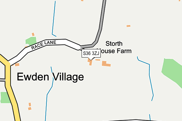
S36 3ZJ is located in the Stocksbridge and Upper Don electoral ward, within the metropolitan district of Sheffield and the English Parliamentary constituency of Penistone and Stocksbridge. The Sub Integrated Care Board (ICB) Location is NHS South Yorkshire ICB - 03N and the police force is South Yorkshire. This postcode has been in use since June 1997.


GetTheData
Source: OS OpenMap – Local (Ordnance Survey)
Source: OS VectorMap District (Ordnance Survey)
Licence: Open Government Licence (requires attribution)
| Easting | 427664 |
| Northing | 396257 |
| Latitude | 53.462338 |
| Longitude | -1.584797 |
GetTheData
Source: Open Postcode Geo
Licence: Open Government Licence
| Country | England |
| Postcode District | S36 |
➜ See where S36 is on a map | |
GetTheData
Source: Land Registry Price Paid Data
Licence: Open Government Licence
Elevation or altitude of S36 3ZJ as distance above sea level:
| Metres | Feet | |
|---|---|---|
| Elevation | 190m | 623ft |
Elevation is measured from the approximate centre of the postcode, to the nearest point on an OS contour line from OS Terrain 50, which has contour spacing of ten vertical metres.
➜ How high above sea level am I? Find the elevation of your current position using your device's GPS.
GetTheData
Source: Open Postcode Elevation
Licence: Open Government Licence
| Ward | Stocksbridge And Upper Don |
| Constituency | Penistone And Stocksbridge |
GetTheData
Source: ONS Postcode Database
Licence: Open Government Licence
| Stone Moor Road (Folderings Lane) | Bolsterstone | 792m |
| Stone Moor Road (Folderings Lane) | Bolsterstone | 794m |
| Cockshot Lane (Royd Lane) | Deepcar | 1,039m |
| Cockshot Lane (Royd Lane) | Deepcar | 1,056m |
| Pen Nook Drive (Royd Lane) | Deepcar | 1,064m |
GetTheData
Source: NaPTAN
Licence: Open Government Licence
| Percentage of properties with Next Generation Access | 100.0% |
| Percentage of properties with Superfast Broadband | 100.0% |
| Percentage of properties with Ultrafast Broadband | 0.0% |
| Percentage of properties with Full Fibre Broadband | 0.0% |
Superfast Broadband is between 30Mbps and 300Mbps
Ultrafast Broadband is > 300Mbps
| Percentage of properties unable to receive 2Mbps | 0.0% |
| Percentage of properties unable to receive 5Mbps | 0.0% |
| Percentage of properties unable to receive 10Mbps | 0.0% |
| Percentage of properties unable to receive 30Mbps | 0.0% |
GetTheData
Source: Ofcom
Licence: Ofcom Terms of Use (requires attribution)
GetTheData
Source: ONS Postcode Database
Licence: Open Government Licence


➜ Get more ratings from the Food Standards Agency
GetTheData
Source: Food Standards Agency
Licence: FSA terms & conditions
| Last Collection | |||
|---|---|---|---|
| Location | Mon-Fri | Sat | Distance |
| 2 St Marys Terrace | 17:30 | 09:45 | 779m |
| Townend Lane | 17:30 | 08:30 | 1,499m |
| 48 Glebelands Road | 18:15 | 08:30 | 1,503m |
GetTheData
Source: Dracos
Licence: Creative Commons Attribution-ShareAlike
The below table lists the International Territorial Level (ITL) codes (formerly Nomenclature of Territorial Units for Statistics (NUTS) codes) and Local Administrative Units (LAU) codes for S36 3ZJ:
| ITL 1 Code | Name |
|---|---|
| TLE | Yorkshire and The Humber |
| ITL 2 Code | Name |
| TLE3 | South Yorkshire |
| ITL 3 Code | Name |
| TLE32 | Sheffield |
| LAU 1 Code | Name |
| E08000019 | Sheffield |
GetTheData
Source: ONS Postcode Directory
Licence: Open Government Licence
The below table lists the Census Output Area (OA), Lower Layer Super Output Area (LSOA), and Middle Layer Super Output Area (MSOA) for S36 3ZJ:
| Code | Name | |
|---|---|---|
| OA | E00041273 | |
| LSOA | E01008147 | Sheffield 002D |
| MSOA | E02001612 | Sheffield 002 |
GetTheData
Source: ONS Postcode Directory
Licence: Open Government Licence
| S36 4AB | Jack Lane | 438m |
| S36 4ZD | Ewden Valley | 464m |
| S36 4ZE | Pheasant Lane | 467m |
| S36 3ZG | New Mill Bank | 527m |
| S36 3ST | More Hall Lane | 555m |
| S36 3SS | Bank Lane | 758m |
| S36 3ZH | Walders Lane | 778m |
| S36 3ZD | Castle Croft Lane | 779m |
| S36 3ZL | St Marys Terrace | 791m |
| S36 3ZE | Folderings Lane | 795m |
GetTheData
Source: Open Postcode Geo; Land Registry Price Paid Data
Licence: Open Government Licence