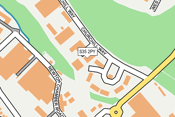
S35 2PY lies on Churchill Way in Chapeltown, Sheffield. S35 2PY is located in the West Ecclesfield electoral ward, within the metropolitan district of Sheffield and the English Parliamentary constituency of Penistone and Stocksbridge. The Sub Integrated Care Board (ICB) Location is NHS South Yorkshire ICB - 03N and the police force is South Yorkshire. This postcode has been in use since July 2003.


GetTheData
Source: OS OpenMap – Local (Ordnance Survey)
Source: OS VectorMap District (Ordnance Survey)
Licence: Open Government Licence (requires attribution)
| Easting | 435025 |
| Northing | 397613 |
| Latitude | 53.474107 |
| Longitude | -1.473781 |
GetTheData
Source: Open Postcode Geo
Licence: Open Government Licence
| Street | Churchill Way |
| Locality | Chapeltown |
| Town/City | Sheffield |
| Country | England |
| Postcode District | S35 |
➜ See where S35 is on a map ➜ Where is Chapeltown? | |
GetTheData
Source: Land Registry Price Paid Data
Licence: Open Government Licence
Elevation or altitude of S35 2PY as distance above sea level:
| Metres | Feet | |
|---|---|---|
| Elevation | 110m | 361ft |
Elevation is measured from the approximate centre of the postcode, to the nearest point on an OS contour line from OS Terrain 50, which has contour spacing of ten vertical metres.
➜ How high above sea level am I? Find the elevation of your current position using your device's GPS.
GetTheData
Source: Open Postcode Elevation
Licence: Open Government Licence
| Ward | West Ecclesfield |
| Constituency | Penistone And Stocksbridge |
GetTheData
Source: ONS Postcode Database
Licence: Open Government Licence
| Thorncliffe Works (Thorncliffe Road) | Chapeltown | 187m |
| Thorncliffe Works (Thorncliffe Road) | Chapeltown | 201m |
| Newton Chambers Road (Cart Road) | Chapeltown | 387m |
| Newton Chambers Road (Cart Road) | Chapeltown | 409m |
| Brookdale Road Terminus (Brookdale Road) | Warren | 429m |
| Chapeltown Station | 1.4km |
| Elsecar Station | 4.1km |
| Wombwell Station | 6.1km |
GetTheData
Source: NaPTAN
Licence: Open Government Licence
Estimated total energy consumption in S35 2PY by fuel type, 2015.
| Consumption (kWh) | 177,067 |
|---|---|
| Meter count | 9 |
| Mean (kWh/meter) | 19,674 |
| Median (kWh/meter) | 16,486 |
GetTheData
Source: Postcode level gas estimates: 2015 (experimental)
Source: Postcode level electricity estimates: 2015 (experimental)
Licence: Open Government Licence
GetTheData
Source: ONS Postcode Database
Licence: Open Government Licence


➜ Get more ratings from the Food Standards Agency
GetTheData
Source: Food Standards Agency
Licence: FSA terms & conditions
| Last Collection | |||
|---|---|---|---|
| Location | Mon-Fri | Sat | Distance |
| Thorncliffe Park Estate | 18:30 | 340m | |
| Thorncliffe Park Estate | 18:30 | 11:45 | 341m |
| 110 Mortomley Lane | 17:30 | 11:30 | 683m |
GetTheData
Source: Dracos
Licence: Creative Commons Attribution-ShareAlike
The below table lists the International Territorial Level (ITL) codes (formerly Nomenclature of Territorial Units for Statistics (NUTS) codes) and Local Administrative Units (LAU) codes for S35 2PY:
| ITL 1 Code | Name |
|---|---|
| TLE | Yorkshire and The Humber |
| ITL 2 Code | Name |
| TLE3 | South Yorkshire |
| ITL 3 Code | Name |
| TLE32 | Sheffield |
| LAU 1 Code | Name |
| E08000019 | Sheffield |
GetTheData
Source: ONS Postcode Directory
Licence: Open Government Licence
The below table lists the Census Output Area (OA), Lower Layer Super Output Area (LSOA), and Middle Layer Super Output Area (MSOA) for S35 2PY:
| Code | Name | |
|---|---|---|
| OA | E00172527 | |
| LSOA | E01007889 | Sheffield 004B |
| MSOA | E02001614 | Sheffield 004 |
GetTheData
Source: ONS Postcode Directory
Licence: Open Government Licence
| S35 3XZ | Ironstone Drive | 403m |
| S35 2YL | Newton Vale | 417m |
| S35 2TD | Chambers Grove | 429m |
| S35 3XX | Thorncliffe Lane | 449m |
| S35 3XU | Thorncliffe View | 452m |
| S35 3AN | Heyhouse Drive | 503m |
| S35 3XW | Ironstone Crescent | 504m |
| S35 2XZ | Warren Gardens | 511m |
| S35 2TA | Chambers Drive | 517m |
| S35 3XT | Ironstone Crescent | 518m |
GetTheData
Source: Open Postcode Geo; Land Registry Price Paid Data
Licence: Open Government Licence