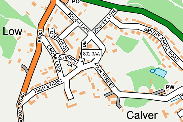
S32 3AA is located in the Calver & Longstone electoral ward, within the local authority district of Derbyshire Dales and the English Parliamentary constituency of Derbyshire Dales. The Sub Integrated Care Board (ICB) Location is NHS Derby and Derbyshire ICB - 15M and the police force is Derbyshire. This postcode has been in use since June 1997.


GetTheData
Source: OS OpenMap – Local (Ordnance Survey)
Source: OS VectorMap District (Ordnance Survey)
Licence: Open Government Licence (requires attribution)
| Easting | 424041 |
| Northing | 374601 |
| Latitude | 53.267861 |
| Longitude | -1.641004 |
GetTheData
Source: Open Postcode Geo
Licence: Open Government Licence
| Country | England |
| Postcode District | S32 |
➜ See where S32 is on a map ➜ Where is Calver? | |
GetTheData
Source: Land Registry Price Paid Data
Licence: Open Government Licence
Elevation or altitude of S32 3AA as distance above sea level:
| Metres | Feet | |
|---|---|---|
| Elevation | 140m | 459ft |
Elevation is measured from the approximate centre of the postcode, to the nearest point on an OS contour line from OS Terrain 50, which has contour spacing of ten vertical metres.
➜ How high above sea level am I? Find the elevation of your current position using your device's GPS.
GetTheData
Source: Open Postcode Elevation
Licence: Open Government Licence
| Ward | Calver & Longstone |
| Constituency | Derbyshire Dales |
GetTheData
Source: ONS Postcode Database
Licence: Open Government Licence
| Hassop Road | Calver | 180m |
| Hassop Road | Calver | 237m |
| Crossroads (A623) | Calver | 308m |
| Crossroads (A623) | Calver | 342m |
| Calver Sough (Grindleford Road A625) | Calver | 346m |
| Grindleford Station | 4.3km |
GetTheData
Source: NaPTAN
Licence: Open Government Licence
GetTheData
Source: ONS Postcode Database
Licence: Open Government Licence


➜ Get more ratings from the Food Standards Agency
GetTheData
Source: Food Standards Agency
Licence: FSA terms & conditions
| Last Collection | |||
|---|---|---|---|
| Location | Mon-Fri | Sat | Distance |
| Calver Post Office | 16:30 | 11:00 | 21m |
| Outside Craft Centre | 16:30 | 11:00 | 529m |
| The Avenue | 16:15 | 11:15 | 860m |
GetTheData
Source: Dracos
Licence: Creative Commons Attribution-ShareAlike
The below table lists the International Territorial Level (ITL) codes (formerly Nomenclature of Territorial Units for Statistics (NUTS) codes) and Local Administrative Units (LAU) codes for S32 3AA:
| ITL 1 Code | Name |
|---|---|
| TLF | East Midlands (England) |
| ITL 2 Code | Name |
| TLF1 | Derbyshire and Nottinghamshire |
| ITL 3 Code | Name |
| TLF13 | South and West Derbyshire |
| LAU 1 Code | Name |
| E07000035 | Derbyshire Dales |
GetTheData
Source: ONS Postcode Directory
Licence: Open Government Licence
The below table lists the Census Output Area (OA), Lower Layer Super Output Area (LSOA), and Middle Layer Super Output Area (MSOA) for S32 3AA:
| Code | Name | |
|---|---|---|
| OA | E00099155 | |
| LSOA | E01019604 | Derbyshire Dales 002B |
| MSOA | E02004069 | Derbyshire Dales 002 |
GetTheData
Source: ONS Postcode Directory
Licence: Open Government Licence
| S32 3XJ | Folds Head | 39m |
| S32 3XQ | Low Side | 54m |
| S32 3XP | High Street | 115m |
| S32 3XS | Cross Lane | 127m |
| S32 3WZ | Lowside Close | 142m |
| S32 3XX | Well Green | 153m |
| S32 3XR | Main Street | 158m |
| S32 3WY | Sough Lane | 170m |
| S32 3XN | Hassop Road | 228m |
| S32 3XW | Smithy Knoll Road | 232m |
GetTheData
Source: Open Postcode Geo; Land Registry Price Paid Data
Licence: Open Government Licence