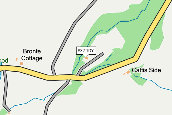
S32 1DY is located in the Hathersage electoral ward, within the local authority district of Derbyshire Dales and the English Parliamentary constituency of Derbyshire Dales. The Sub Integrated Care Board (ICB) Location is NHS Derby and Derbyshire ICB - 15M and the police force is Derbyshire. This postcode has been in use since February 2017.


GetTheData
Source: OS OpenMap – Local (Ordnance Survey)
Source: OS VectorMap District (Ordnance Survey)
Licence: Open Government Licence (requires attribution)
| Easting | 423493 |
| Northing | 383184 |
| Latitude | 53.345051 |
| Longitude | -1.648586 |
GetTheData
Source: Open Postcode Geo
Licence: Open Government Licence
| Country | England |
| Postcode District | S32 |
➜ See where S32 is on a map | |
GetTheData
Source: Land Registry Price Paid Data
Licence: Open Government Licence
| Ward | Hathersage |
| Constituency | Derbyshire Dales |
GetTheData
Source: ONS Postcode Database
Licence: Open Government Licence
| Hollin Bank (Stanage Plantation) | Outseats | 598m |
| Hollin Bank (Stanage Plantation) | Outseats | 601m |
| Cattis Side Moor | Outseats | 716m |
| Cattis Side Moor | Outseats | 734m |
| Sheepwash Bank | Outseats | 828m |
| Hathersage Station | 2.2km |
| Bamford Station | 2.8km |
| Grindleford Station | 4.6km |
GetTheData
Source: NaPTAN
Licence: Open Government Licence
| Percentage of properties with Next Generation Access | 100.0% |
| Percentage of properties with Superfast Broadband | 0.0% |
| Percentage of properties with Ultrafast Broadband | 0.0% |
| Percentage of properties with Full Fibre Broadband | 0.0% |
Superfast Broadband is between 30Mbps and 300Mbps
Ultrafast Broadband is > 300Mbps
| Percentage of properties unable to receive 2Mbps | 0.0% |
| Percentage of properties unable to receive 5Mbps | 0.0% |
| Percentage of properties unable to receive 10Mbps | 40.0% |
| Percentage of properties unable to receive 30Mbps | 100.0% |
GetTheData
Source: Ofcom
Licence: Ofcom Terms of Use (requires attribution)
GetTheData
Source: ONS Postcode Database
Licence: Open Government Licence


➜ Get more ratings from the Food Standards Agency
GetTheData
Source: Food Standards Agency
Licence: FSA terms & conditions
| Last Collection | |||
|---|---|---|---|
| Location | Mon-Fri | Sat | Distance |
| Church Bank | 17:00 | 07:30 | 1,423m |
| Hathersage Post Office | 17:00 | 11:15 | 1,653m |
| Cannonfields | 16:00 | 07:40 | 1,832m |
GetTheData
Source: Dracos
Licence: Creative Commons Attribution-ShareAlike
The below table lists the International Territorial Level (ITL) codes (formerly Nomenclature of Territorial Units for Statistics (NUTS) codes) and Local Administrative Units (LAU) codes for S32 1DY:
| ITL 1 Code | Name |
|---|---|
| TLF | East Midlands (England) |
| ITL 2 Code | Name |
| TLF1 | Derbyshire and Nottinghamshire |
| ITL 3 Code | Name |
| TLF13 | South and West Derbyshire |
| LAU 1 Code | Name |
| E07000035 | Derbyshire Dales |
GetTheData
Source: ONS Postcode Directory
Licence: Open Government Licence
The below table lists the Census Output Area (OA), Lower Layer Super Output Area (LSOA), and Middle Layer Super Output Area (MSOA) for S32 1DY:
| Code | Name | |
|---|---|---|
| OA | E00099238 | |
| LSOA | E01019615 | Derbyshire Dales 001C |
| MSOA | E02004068 | Derbyshire Dales 001 |
GetTheData
Source: ONS Postcode Directory
Licence: Open Government Licence
| S32 1BR | 1269m | |
| S32 1BQ | 1297m | |
| S32 1AJ | Church Bank | 1356m |
| S32 1AP | Dale Crescent | 1391m |
| S32 1AF | Baulk Lane | 1421m |
| S32 1AQ | The Dale | 1423m |
| S32 1EQ | The Dale | 1440m |
| S32 1BZ | School Lane | 1478m |
| S32 1BB | Main Road | 1607m |
| S32 1AY | Hill Lane | 1613m |
GetTheData
Source: Open Postcode Geo; Land Registry Price Paid Data
Licence: Open Government Licence