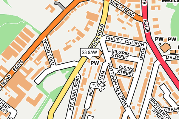
S3 9AW is located in the Burngreave electoral ward, within the metropolitan district of Sheffield and the English Parliamentary constituency of Sheffield, Brightside and Hillsborough. The Sub Integrated Care Board (ICB) Location is NHS South Yorkshire ICB - 03N and the police force is South Yorkshire. This postcode has been in use since January 1980.


GetTheData
Source: OS OpenMap – Local (Ordnance Survey)
Source: OS VectorMap District (Ordnance Survey)
Licence: Open Government Licence (requires attribution)
| Easting | 435486 |
| Northing | 389000 |
| Latitude | 53.396644 |
| Longitude | -1.467804 |
GetTheData
Source: Open Postcode Geo
Licence: Open Government Licence
| Country | England |
| Postcode District | S3 |
➜ See where S3 is on a map ➜ Where is Sheffield? | |
GetTheData
Source: Land Registry Price Paid Data
Licence: Open Government Licence
Elevation or altitude of S3 9AW as distance above sea level:
| Metres | Feet | |
|---|---|---|
| Elevation | 100m | 328ft |
Elevation is measured from the approximate centre of the postcode, to the nearest point on an OS contour line from OS Terrain 50, which has contour spacing of ten vertical metres.
➜ How high above sea level am I? Find the elevation of your current position using your device's GPS.
GetTheData
Source: Open Postcode Elevation
Licence: Open Government Licence
| Ward | Burngreave |
| Constituency | Sheffield, Brightside And Hillsborough |
GetTheData
Source: ONS Postcode Database
Licence: Open Government Licence
| Pilgrim Street (Nottingham Street) | Pitsmoor | 53m |
| Pilgrim Street (Nottingham Street) | Pitsmoor | 73m |
| *** Observed By Services Not In Sis *** (Pitsmoor Road) | Pitsmoor | 128m |
| Fox Street (Nottingham Street) | Pitsmoor | 143m |
| Minna Road (Pitsmoor Road) | Pitsmoor | 144m |
| Shalesmoor (Sheffield Supertram) (Corner Of Netherthorpe Rd And Shalesmoor) | Shalesmoor | 1,114m |
| Infirmary Road (Sheffield Supertram) (Infirmary Road) | Upperthorpe | 1,167m |
| Langsett - Primrose View (Sheffield Supertram) (Langsett Road) | Langsett Road | 1,436m |
| Fitzalan Sq - Ponds Forge (Sheffield Supertram) (Commercial Street) | Sheffield Centre | 1,522m |
| Netherthorpe Road (Sheffield Supertram) (Netherthorpe Road) | Netherthorpe | 1,648m |
| Sheffield Station | 2.1km |
| Darnall Station | 3.9km |
| Meadowhall Station | 4.3km |
GetTheData
Source: NaPTAN
Licence: Open Government Licence
| Percentage of properties with Next Generation Access | 100.0% |
| Percentage of properties with Superfast Broadband | 100.0% |
| Percentage of properties with Ultrafast Broadband | 100.0% |
| Percentage of properties with Full Fibre Broadband | 0.0% |
Superfast Broadband is between 30Mbps and 300Mbps
Ultrafast Broadband is > 300Mbps
| Percentage of properties unable to receive 2Mbps | 0.0% |
| Percentage of properties unable to receive 5Mbps | 0.0% |
| Percentage of properties unable to receive 10Mbps | 0.0% |
| Percentage of properties unable to receive 30Mbps | 0.0% |
GetTheData
Source: Ofcom
Licence: Ofcom Terms of Use (requires attribution)
Estimated total energy consumption in S3 9AW by fuel type, 2015.
| Consumption (kWh) | 41,555 |
|---|---|
| Meter count | 6 |
| Mean (kWh/meter) | 6,926 |
| Median (kWh/meter) | 2,307 |
GetTheData
Source: Postcode level gas estimates: 2015 (experimental)
Source: Postcode level electricity estimates: 2015 (experimental)
Licence: Open Government Licence
GetTheData
Source: ONS Postcode Database
Licence: Open Government Licence


➜ Get more ratings from the Food Standards Agency
GetTheData
Source: Food Standards Agency
Licence: FSA terms & conditions
| Last Collection | |||
|---|---|---|---|
| Location | Mon-Fri | Sat | Distance |
| 175 Nottingham Street | 17:45 | 10:00 | 186m |
| Burgreave Road | 17:30 | 12:00 | 267m |
| Oakham Drive | 18:30 | 475m | |
GetTheData
Source: Dracos
Licence: Creative Commons Attribution-ShareAlike
The below table lists the International Territorial Level (ITL) codes (formerly Nomenclature of Territorial Units for Statistics (NUTS) codes) and Local Administrative Units (LAU) codes for S3 9AW:
| ITL 1 Code | Name |
|---|---|
| TLE | Yorkshire and The Humber |
| ITL 2 Code | Name |
| TLE3 | South Yorkshire |
| ITL 3 Code | Name |
| TLE32 | Sheffield |
| LAU 1 Code | Name |
| E08000019 | Sheffield |
GetTheData
Source: ONS Postcode Directory
Licence: Open Government Licence
The below table lists the Census Output Area (OA), Lower Layer Super Output Area (LSOA), and Middle Layer Super Output Area (MSOA) for S3 9AW:
| Code | Name | |
|---|---|---|
| OA | E00039861 | |
| LSOA | E01007870 | Sheffield 019A |
| MSOA | E02001629 | Sheffield 019 |
GetTheData
Source: ONS Postcode Directory
Licence: Open Government Licence
| S3 9GU | Nottingham Cliff | 88m |
| S3 9HJ | Nottingham Street | 108m |
| S3 9HN | Christ Church Road | 110m |
| S3 9GX | Pilgrim Street | 119m |
| S3 9GS | Pye Bank Road | 120m |
| S3 9GW | Rising Street | 126m |
| S3 9AQ | Pitsmoor Road | 129m |
| S3 9PE | Woodfold | 135m |
| S3 9HL | Nottingham Street | 140m |
| S3 9HE | Fox Street | 155m |
GetTheData
Source: Open Postcode Geo; Land Registry Price Paid Data
Licence: Open Government Licence