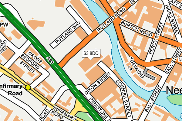
S3 8DQ is located in the City electoral ward, within the metropolitan district of Sheffield and the English Parliamentary constituency of Sheffield Central. The Sub Integrated Care Board (ICB) Location is NHS South Yorkshire ICB - 03N and the police force is South Yorkshire. This postcode has been in use since April 1987.


GetTheData
Source: OS OpenMap – Local (Ordnance Survey)
Source: OS VectorMap District (Ordnance Survey)
Licence: Open Government Licence (requires attribution)
| Easting | 434758 |
| Northing | 388415 |
| Latitude | 53.391434 |
| Longitude | -1.478816 |
GetTheData
Source: Open Postcode Geo
Licence: Open Government Licence
| Country | England |
| Postcode District | S3 |
➜ See where S3 is on a map ➜ Where is Sheffield? | |
GetTheData
Source: Land Registry Price Paid Data
Licence: Open Government Licence
Elevation or altitude of S3 8DQ as distance above sea level:
| Metres | Feet | |
|---|---|---|
| Elevation | 50m | 164ft |
Elevation is measured from the approximate centre of the postcode, to the nearest point on an OS contour line from OS Terrain 50, which has contour spacing of ten vertical metres.
➜ How high above sea level am I? Find the elevation of your current position using your device's GPS.
GetTheData
Source: Open Postcode Elevation
Licence: Open Government Licence
| Ward | City |
| Constituency | Sheffield Central |
GetTheData
Source: ONS Postcode Database
Licence: Open Government Licence
| Rutland Road (Penistone Road) | Shalesmoor | 88m |
| Bedford Street (Penistone Road) | Shalesmoor | 126m |
| St. Phillips Road (Penistone Road) | Shalesmoor | 172m |
| Rutland Road (Neepsend Lane) | Neepsend | 198m |
| Penistone Road (Infirmary Road) | Shalesmoor | 203m |
| Infirmary Road (Sheffield Supertram) (Infirmary Road) | Upperthorpe | 250m |
| Shalesmoor (Sheffield Supertram) (Corner Of Netherthorpe Rd And Shalesmoor) | Shalesmoor | 313m |
| Netherthorpe Road (Sheffield Supertram) (Netherthorpe Road) | Netherthorpe | 786m |
| Langsett - Primrose View (Sheffield Supertram) (Langsett Road) | Langsett Road | 850m |
| City Hall (Sheffield Supertram) (West Street) | Sheffield Centre | 1,147m |
| Sheffield Station | 1.8km |
| Darnall Station | 4.5km |
| Meadowhall Station | 5.3km |
GetTheData
Source: NaPTAN
Licence: Open Government Licence
GetTheData
Source: ONS Postcode Database
Licence: Open Government Licence

➜ Get more ratings from the Food Standards Agency
GetTheData
Source: Food Standards Agency
Licence: FSA terms & conditions
| Last Collection | |||
|---|---|---|---|
| Location | Mon-Fri | Sat | Distance |
| Petrol Station | 17:30 | 12:00 | 246m |
| Burton Road | 17:45 | 10:00 | 326m |
| Burton Road | 18:30 | 332m | |
GetTheData
Source: Dracos
Licence: Creative Commons Attribution-ShareAlike
| Risk of S3 8DQ flooding from rivers and sea | Low |
| ➜ S3 8DQ flood map | |
GetTheData
Source: Open Flood Risk by Postcode
Licence: Open Government Licence
The below table lists the International Territorial Level (ITL) codes (formerly Nomenclature of Territorial Units for Statistics (NUTS) codes) and Local Administrative Units (LAU) codes for S3 8DQ:
| ITL 1 Code | Name |
|---|---|
| TLE | Yorkshire and The Humber |
| ITL 2 Code | Name |
| TLE3 | South Yorkshire |
| ITL 3 Code | Name |
| TLE32 | Sheffield |
| LAU 1 Code | Name |
| E08000019 | Sheffield |
GetTheData
Source: ONS Postcode Directory
Licence: Open Government Licence
The below table lists the Census Output Area (OA), Lower Layer Super Output Area (LSOA), and Middle Layer Super Output Area (MSOA) for S3 8DQ:
| Code | Name | |
|---|---|---|
| OA | E00172496 | |
| LSOA | E01033263 | Sheffield 073C |
| MSOA | E02006843 | Sheffield 073 |
GetTheData
Source: ONS Postcode Directory
Licence: Open Government Licence
| S3 8DG | Rutland Way | 115m |
| S3 8BJ | Adelaide Lane | 136m |
| S6 3AE | Cornish Street | 150m |
| S6 3BA | Cross Bedford Street | 168m |
| S3 8AF | Lancaster Street | 171m |
| S6 3DD | Infirmary Road | 190m |
| S6 3BS | Cross Bedford Street | 193m |
| S6 3BT | Bedford Street | 197m |
| S6 3AF | Cornish Place | 210m |
| S6 3BZ | Infirmary Road | 217m |
GetTheData
Source: Open Postcode Geo; Land Registry Price Paid Data
Licence: Open Government Licence